|
Abstract
Complex, sometimes contradictory geologic theories to explain this desolate Mars environment have been proposed, based on a wide variety of observed surface phenomena and features. A new model that reconciles major puzzling contradictions among past models is now put forth, using new observations from MGS high-resolution images of Mars and a reevaluation of certain Viking era experiments.
Small-scale surface features are identified which, it is proposed, are the direct product of wide spread ancient and recent bursts of subsurface liquid water. These water “stains” are shown to cluster (beyond statistical chance) in an unmistakable tidally-determined, bi-modal distribution on the planet: centered near the Tharsis and antipodal Arabia “bulges.”
A revaluation of Mars ancient history is therefore proposed, suggesting that Mars (well after solar system formation) was captured into synchronous orbital lock with a larger planetary companion (“Planet V”), accounting for the clustering of present day water bursts around the former beds of two bi-modally distributed “Mars ancient oceans” as a direct result. The current Tharsis and Arabia mantle uplifts are shown to be an inevitable additional fossil signature of such former tidal stresses, induced by a close gravitational relationship with Planet V.
Other heretofore inexplicable Martian surface features are shown to be consistent with such a simple "tidal model":
The long-mysterious “Line of Dichotomy” is explained as a remnant of a “blast wave” of debris from this sudden severing of the former orbital lock relationship with Planet V, due to either a catastrophic collision or explosion.
Chemical signatures of this extraordinary destruction event on Mars,
Mars unusual magnetic field “striping” is now shown to be another unique southern hemisphere signature of this destruction event, caused by standing P and S waves reverberating through the planet’s crust as a result of the massive simultaneous impacts from Planet V debris. Recently published research showing unprecedented outflow channels from the Tharsis and Arabia bulges are shown to be consistent with the sudden relaxation of the two tidal oceans, as is the sculpting of huge amounts of material by fluvial processes north of the Arabia bulge.
Two possible mechanisms for the
destruction of Planet V and the breaking of this tidal lock are
outlined. Finally, a new timeline for Mars geologic evolution is
proposed that is consistent with these observations, placing these
events between capture ~500 MYA and the destruction of Planet V at
65 MYA.
Man’s fascination with Mars has led to many fanciful and romantic notions about the planet’s genesis. Early popular (and even some scientific) speculations focused on a planet populated by exotic creatures if not warring advanced civilizations; these were based in large part on Lowell’s turn-of-the-Century model of a harsh and frigid Mars, one that was still habitable, though dying.
It was not until the 1964 Mariner 4
mission that the general public and the scientific community got
their first close-up view of the real Mars -- as Mariner 4 flew by
at a distance of 6,118 miles. The 21 images telemetered back to JPL
surprisingly revealed a cratered terrain more akin to the lifeless
lunar surface than anything on Earth. With these first insitu
spacecraft Mars data, hopes for finding anything approaching another
“Earth” elsewhere in this solar system were permanently dashed.
Subsequent missions confirmed that the Martian atmosphere was much
too thin and the temperatures too low to allow for the presence of
surface liquid water, eliminating almost any remaining hope of
finding current life.
Among the principal reasons cited for consensus against the LRE was the absence of available liquid water on the Martian surface – a key prerequisite for life. This general dismissal of the LRE results was immediately challenged by the LRE’s Principal Investigator, Gilbert Levin. Levin3 showed that liquid water could flow on the present day Martian surface, if the available water was restricted to the lower 1-3 km of atmosphere, rather than being evenly distributed throughout its depth. Meteorological data from Mars Pathfinder later confirmed the Levin model for atmospheric water distribution.4
One remarkable development in this regard has been the rediscovery of 25-year-old “lost” NASA data from Levin’s own experiment. Joseph Miller, a neurobiologist at the University of Southern California, recently presented evidence that the radioactive CO2 release that was the heart of Levin’s experiment exhibited a clear 24.66-hour Martian diurnal cycle – precisely the circadian rhythm to be expected of living Martian microbes in the soil.5 If confirmed, this would strongly indicate current microbial organisms on Mars – despite a quarter-century of disclaimers and the apparent dearth of liquid water.
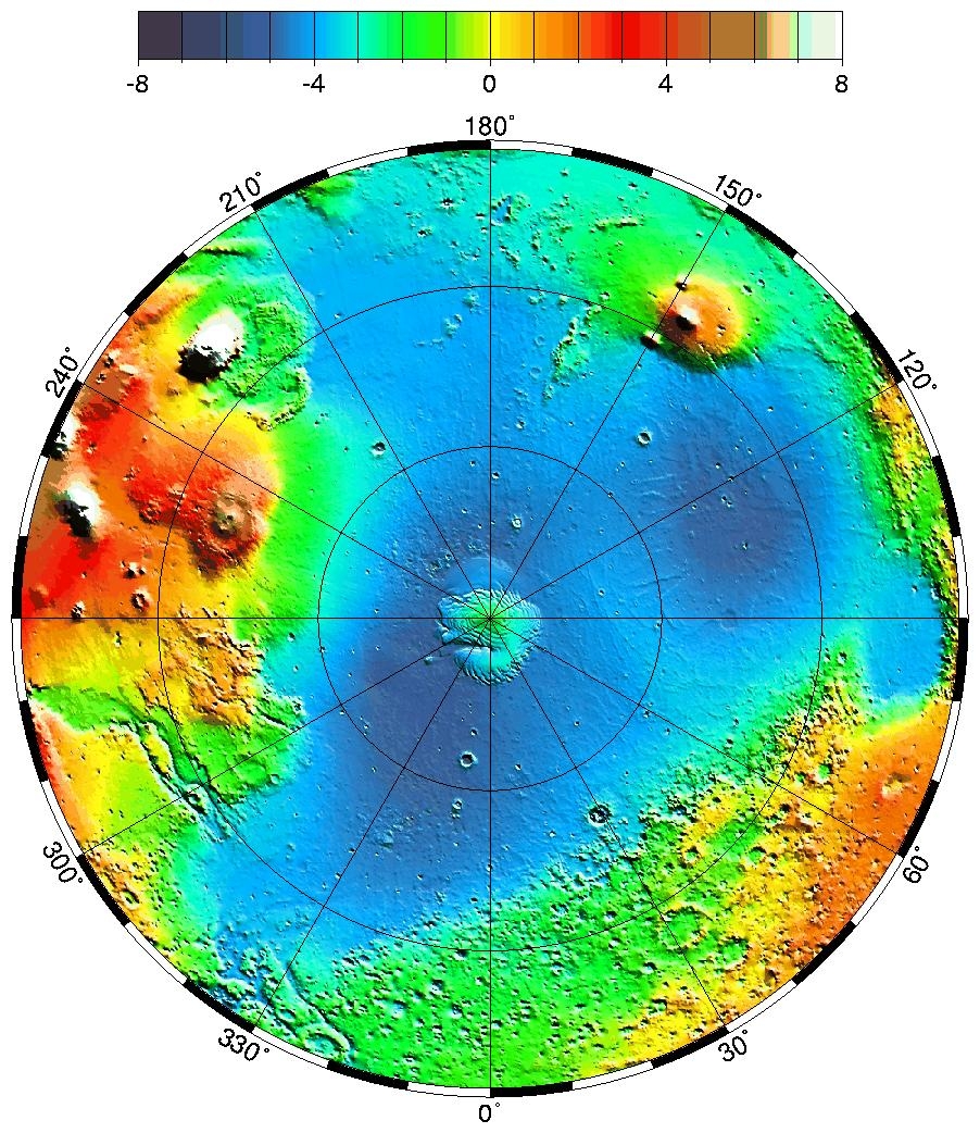
Figure 1 MOLA colorized image of Mars showing the heavily cratered southern highlands (yellow and orange) and the smooth,
sparsely cratered
northern lowlands (blue and green). Other surface features present more difficult problems for geologists. There are vast differences in crater densities between the northern and southern planetary hemispheres. In the North, medium-sized craters are rarely seen, with significant distances between them. This is in distinct contrast with the South, where craters are so numerous that they overlap each other, making it difficult to distinguish between individual impacts.
This stark difference is mysteriously
emphasized by a “Line of Dichotomy”: a separation line running
around the circumference of the planet at about a 35-degree angle to
the Equator. The southern, heavily cratered side of the line, is
also (mysteriously) nearly 30 kilometers (on average) higher than
the northern sparsely cratered lowlands.
However, the lack of smaller
craters on the northern plains (based on relative dating of similar cratering statistics from the Moon) paradoxically implies a
relatively recent date for this proposed “event.”
In 1978, Naval Observatory astronomer and celestial mechanics expert, Thomas Van Flandern, put forth the idea (based on an original model by Olbers) that a relatively recent “exploded planet” in the asteroid belt between Mars and Jupiter was responsible for the origins of most comets and asteroids in the solar system.8
This notion, called the Exploded Planet
Hypothesis (EPH)9, has found little support in the planetary science
community, but its lines of evidence since its initial publication
over twenty years ago have become increasingly compelling. Part and
parcel to this hypothesis is the idea that half Mars visible surface
was devastated by this proposed explosion event, neatly accounting
for the cratering dichotomy between the northern and southern
hemispheres, and the loss of a once dense and possibly life
sustaining atmosphere.
Hancock’s idea is based on Donald W.
Patten and Samuel L. Windsor’s research,11 who surmise that this
object was in fact a “rogue planet” they call “Astra,” described in
their book “The Scars of Mars.” There are however numerous problems
with the “Astra” concept – for instance, it cannot account for the
presence of the asteroid belt, while the EPH does so intrinsically.
The authors of this paper believe that the EPH is the much stronger
hypothesis (if appropriately modified), and that it has already
demonstrated a capacity to survive serious falsification efforts,
qualities not shared by “Astra.”
Recently, Van Flandern has extended the EPH to include the notion that several “planets” (Pluto, Mercury, and Mars) are actually former moons of current or destroyed planets. Evidence to support this hypothesis is extensive, but for our purposes we will focus exclusively on the evidence for Mars. Of these lines of evidence, we will address here only a few as relevant to our proposal. A more complete analysis will be left to a follow–on paper.
Some of the evidence, as compiled by Van Flandern:
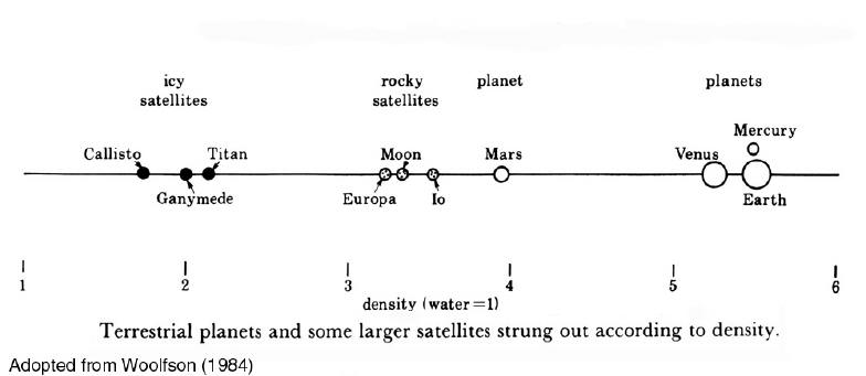
Previous to this, Dorman & Woolfson (1977), writing in the Philosophical Transactions of the Royal Society of London, resented a model called “the Capture Theory of Planetary Formation.” They proposed that Mars was once an original (not captured) moon of one of two colliding “protoplanets” in the early accretion solar system phase.12
They even provided one specific piece of
evidence to support their idea that Mars began as such a satellite:
Mars density is much closer to that of some of the Galilean
satellites than it is to Venus, the least dense inner planet. This
implies a genesis more in common with Io, Europa and Earth’s Moon
than with the terrestrial planets.
Figure 2 Terrestrial planets and larger satellites listed according to density. Mars is much closer to Earth’s Moon, Io, and Europa in density than it is to Venus, the first major terrestrial planet listed.
Van Flandern’s EPH Model proposes that there were formerly two massive planetary bodies in the current orbits of Mars and the Asteroid Belt, respectively. Both exploded. The first (Planet K) detonated in the orbit of the current Belt “several hundred million years ago.” The second (Planet V) exploded near the present day orbit of Mars, some 65 million years ago (MYA). In Van Flandern’s theory, additional impact damage was done to Mars when a much smaller second former moon of Planet V exploded in Mars vicinity 3.2 MYA.
In our modification of the EPH, we will
show that it is not necessary to invoke a literal planetary
“explosion” to produce all the subsequent effects Van Flandern has
proposed, including the formation of asteroids and comets, and the
escape of most of the remaining mass from solar influence. In doing
so, we will draw upon new data not available when Van Flandern
originally formulated his EPH ideas, specifically, observations of
certain Extra Solar planets that follow orbits similar to what we
are proposing led to Mars initial capture as a satellite, and then
the destruction of its “foster parent,” Planet V.
If Mars, prior to its capture (in our
model) formerly had a denser atmosphere that provided for liquid
water on the surface, it is likely that this water – dependent on
the amount -- was distributed in lakes or oceans, much as it is here
on Earth. If this was the case, there should still be pockets of
this water trapped beneath those former lake or ocean beds,
relatively close to the surface, dependent on how long ago the water
actually flowed. If extensive “fields” of this frozen or (sometimes)
liquid water were discovered near the surface, this would strongly
imply such former “lakes” or “oceans” were the source.
Figure 3 Proposed fossilized water runoff channels.
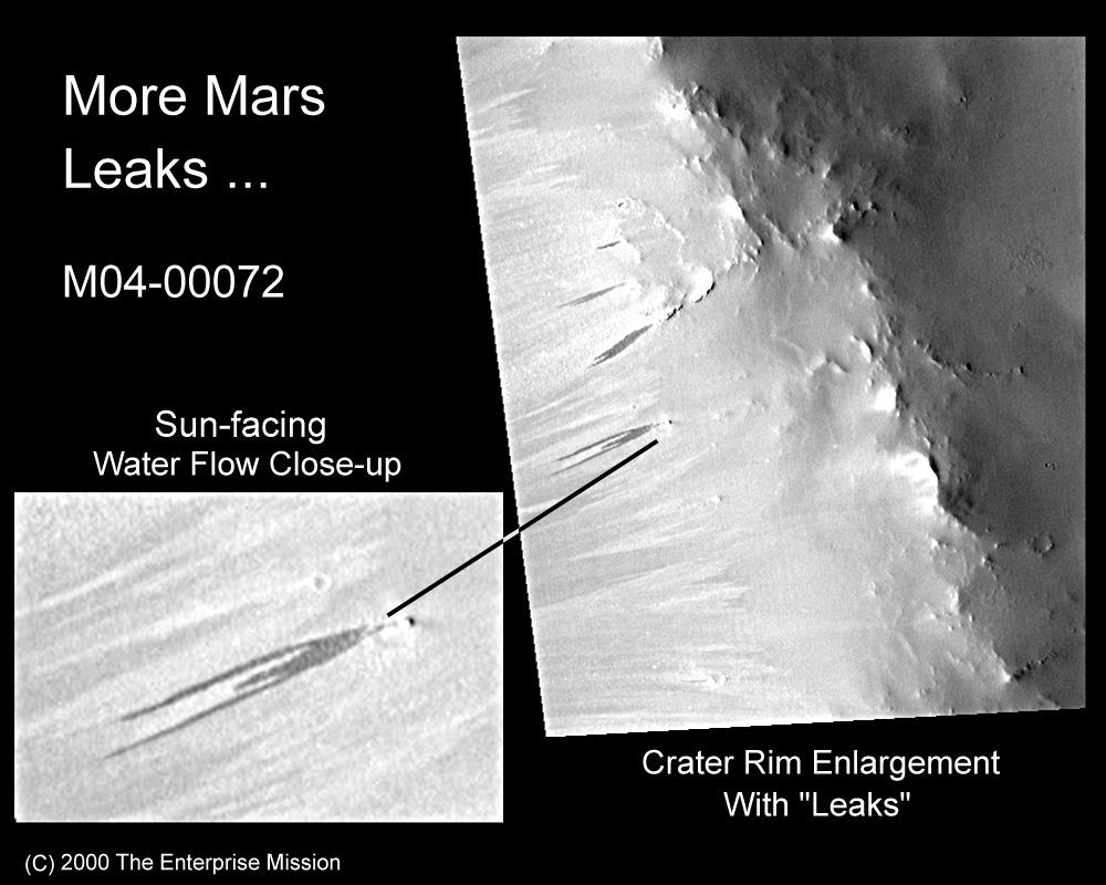
(MSSS/NASA) In 1998, one of a growing number of “independent researchers,” Byran Butcher, noticed and published on the Internet a curious “dark area.” He casually suggested it might be “a coffee stain, water, or a shadow.”15 In July 2000, the authors published a much more specific model, based on an MOC image of an unusually dark, highly elongated “stain” emanating from an exterior point source on a crater wall, proposing that it was a current water flow consistent with the model Malin and Edgett had put forth a few days earlier.16
They quickly found numerous additional examples.
Figure 4 Proposed point source liquid water burst image from MO4-00072
(MSSS/NASA)
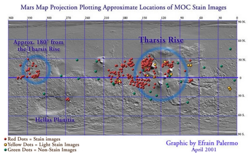
Subsequent to this, Palermo, England and
Moore also found that surface “stains” were inconsistent with aeolian features, mass wasting or other non-fluvial processes.17 At
the suggestion of one of the authors (Hoagland), Palermo et-al then
proceeded to systematically map the locations of these “seep” images
relative to Mars surface coordinates, to see if there was a global
pattern to their distribution. As a control, they also mapped
randomly-selected “non-stain” images until a representative and
statistically valid sampling had been completed.
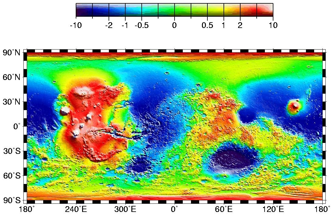
Figure 5 Map showing flow image distribution.
The second, more important pattern discovered was that the water
flows seemed to cluster preferentially around two pronounced
geological features on the Martian surface: the Tharsis and Arabia
mantle uplifts (“bulges” -- Figure 5). The theoretical factors
behind this second (and very pronounced) bimodal “stain”
distribution pattern are the primary subjects of this paper.
The authors are
proposing in this paper that Mars, at some point earlier in solar
system history, was captured by one of two larger planetary bodies
orbiting near the present day orbit of Mars. This scenario is an
extension of the Capture Theory model of solar system formation put
forth by Dorman & Woolfson (1977), as well as Van Flandern’s
Exploded Planet Hypothesis (1978). It is also based on current
observations of significantly elliptical orbits for many
newly-discovered Extra Solar planets around nearby stars, as
reported by Butler, et-al.19
An encounter of Mars with such a system, billions of years after its formation (as we are proposing), would thus have a reasonable probability of encountering a satellite as well. This type of encounter has a much higher probability of happening than the previous scenario presented (the three-body interaction of Planet K, Planet V, and Mars).
But, this second type of encounter could also result in Mars being captured by Planet V – via the ejection of one of Planet V’s own moons. Calculations examining similar scenarios have been performed in connection with the anomalous Neptune system – which consists now of a major planet-sized satellite (Triton) in retrograde orbit, and a smaller moon (Nereid) in a highly elliptical one.
This has been viewed for years as prima-facie evidence for a highly unusual Neptune encounter earlier in solar system history with an outside object in heliocentric orbit, which reversed Triton’s orbit and ejected a previous moon from the system entirely. That “escaped satellite” is now known as “Pluto.” 23
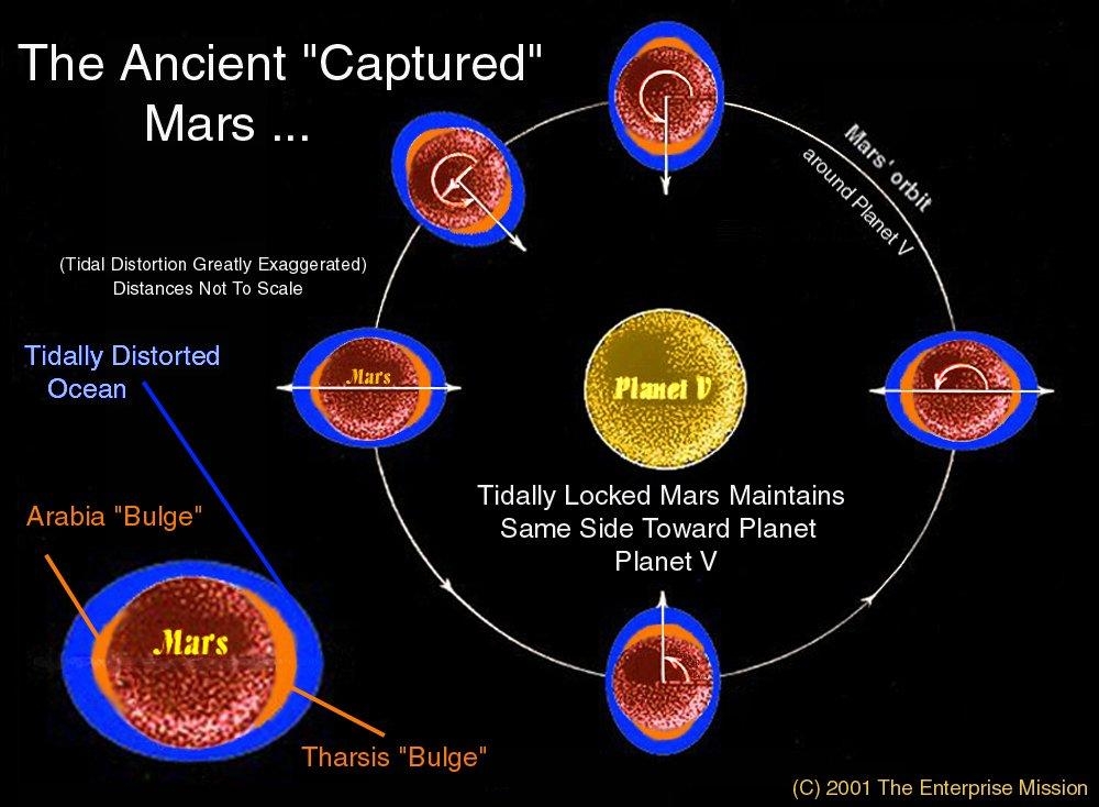
Figure 6 Mars captured by the larger Planet V and brought into a tidal lock relationship, with gravitational bulges developing on opposite sides of Mars, 90 degrees to the spin axis of Planet V. Bulges precisely correspond to the Tharsis and Arabia bulges, 180 degrees apart.
Regardless of the precise methodology of capture, the subsequent, strong tidal relationship between Mars and the more massive Planet V (Figure 6) would have resulted in a further, rapid loss of Mars spin angular momentum, from a “free” rotation period in solar orbit on the order of ~12 hours down to the presently observed ~24.
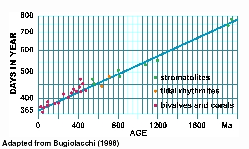
This estimate is based on models of Earth’s primordial rotation slowed by early lunar tides ( Figure 7). 24 In the model, inevitable tidal evolution not only ultimately circularized Mars orbit around Planet V, it resulted in Mars finally rotating/revolving around Planet V synchronously, in approximately 24 hours -- with one side always facing Planet V, as Earth’s Moon does today.
Figure 7
Growth increments of
fossils and tidal sediments on Earth record
It is the authors’ central proposal in this paper that it was this
verifiable “Mars tidal lock relationship” with Planet V that
accounts for a host of previously inexplicable and even
contradictory Martian surface features, that otherwise will remain
perpetually mysterious.
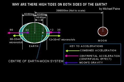
As would be expected from such a tidal situation, a smaller but still significant “anti-bulge” would inevitably be raised at the antipodal location to Tharsis -- which accounts for the Arabia uplift precisely 180 degrees around the planet.
All formerly fluid or partially fluid bodies in the solar system, including the inner moons of Jupiter and Saturn, show signs of such tidal evolution (Figure 10). Io, in particular, has significant bi-modal tidal bulges, similar to the model we are proposing now for Mars.25
We additionally postulate that other heretofore inexplicable geologic features, such as Valles Marineris and the Elysium Mons, were also an extended result of this former tidal mechanism.
Figure 10 A typical terrestrial tidal bore wave making its way up a river basin
The authors also propose that, when this tidal lock relationship was severed -- by the events directly leading to the destruction of Planet V -- Mars rotational polar axis obliquity, relative to the plane of its satellite orbit, dramatically shifted.
This sudden obliquity shift, as part of this rapidly timed sequence of events, is responsible in the model for the apparent discrepancy of the “Line of Dichotomy” blast wave being inclined about 55 degrees to that rotational axis -- instead of being focused on the Tharsis region itself (see details, below).
Example of typical
anti-podal tidal bulge on Earth
After capture, as this
close orbital relationship between Mars and Planet V evolved and the
orbit circularized over hundreds of thousands or even millions of
years, any surface water of oceanic volume would have “sloshed” back
and forth across the surface of Mars twice every Martian “day,” just
as lunar tides do here on Earth. We assert, based on this intrinsic
tidal process, that Mars at the time of capture had to have been a
“warm, wet world” with both a denser atmosphere and a copious supply
of flowing liquid water, otherwise it would not evidence the major
surface signatures of tidal movement we will demonstrate.
Further, we suggest that this process resulted in the relatively brittle crust of Mars weakening at the eastern base of the now stretched Tharsis rise, resulting in a series of radial fissures opening up – one of which was then radically enlarged to become the Valles Marineris canyon system.
In the model, this original tension crack was inevitably expanded by the erosive effects of a massive volume of directed tidal waters – termed a “tidal bore” 26 (Figure 11) -- rushing back and forth (at several hundred kilometers per hour!) the entire ~ 1600 kilometer plus length of the original fissure, twice each Martian day, in direct response to the original spin rate of Mars and the massive gravitational tides caused by Planet V.
Figure 11 Valles Marineris, a heretofore inexplicable trough extending one quarter of the circumference of Mars, is the largest canyon in the Solar System. The authors submit that this a fluvial trench generated by tidal bore action during Mars’ “captured satellite” phase.
Before Mars’ tidal lock with the larger planet was achieved, this enormous surge would have flowed, always westward, around the circumference of Mars in the direction opposite Mars spin, until it piled up against the immobile eastern side of the pre-capture Tharsis bulge. At that point, when “high tide” passed, the released waters would have rushed (under Mars gravity) back down the canyon system toward the east, scouring the floor once more, until the next “high tide.”
This almost unimaginable force of rushing water, through an expanding canyon system of parallel fissures eventually opened up by the fluvial erosion, would have recurred twice each Martian “day,” possibly for several million years -- until Mars’ rotation was finally stationary relative to Planet V.
It is our proposal that this “scrubbing action” eventually resulted in a radical deepening of the original narrow cleft to form the present day ~7-km-deep, ~4000-km-long canyon system known as “Valles Marineris” – a system (Figure 12) now stretching one quarter of the way around the planet Mars.
Figure 12 Artists conception of Mars as it might have appeared during its “Garden of Eden” period, after capture by Planet V.
This assumes that Mars, like the other planets of the solar system,
prior to its capture had a prograde spin. Thus, the tides induced by
Planet V forced the rising and falling waters to always assault the
eastern side of Tharsis – which is precisely where Valles Marineris
formed.
Presumably, this water primarily resided after “tidal lock” in two
opposing “tidal ocean bulges” – with possible dry land between --
because of the inevitable bi-lobed tidal forces experienced by Mars
as an ultimately synchronously rotating satellite of Planet V.
The evidence argues that, once Mars lost its remaining spin momentum and established this stable synchronous orbital relationship, this was not broken or adjusted significantly until the catastrophic destruction of Planet V. The constant tidal tugging on the two opposing hemispheres of Mars from this synchronous orientation now resulted in a continual uplift of the Tharsis region, and to a lesser extent Arabia, antipodal to the Tharsis rise.
The formerly racing tides would also then have stabilized, and the tidal erosion of Valles Marineris would have totally subsided. At this point, the only additional fluvial erosion processes likely on the planet would have been wind-induced wave action and severe storms. Evidence of the former should still present itself on some key surface features not altered by the subsequent Planet V destruction.
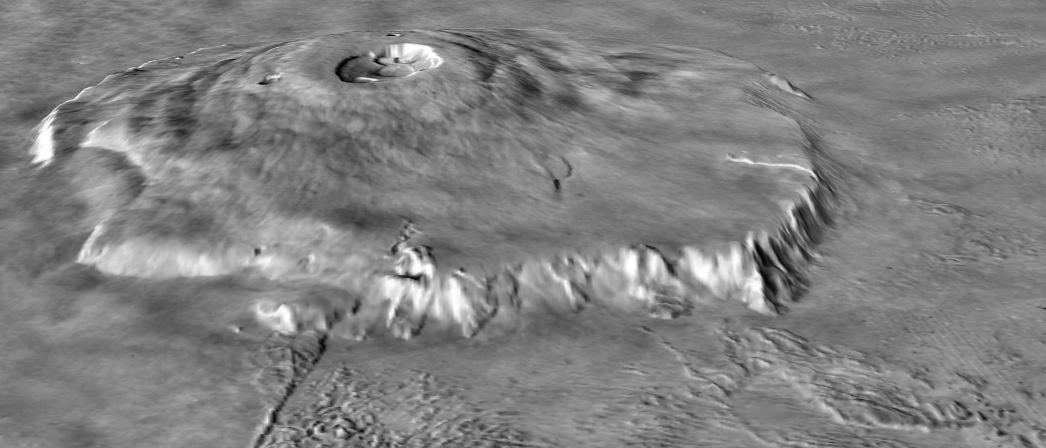
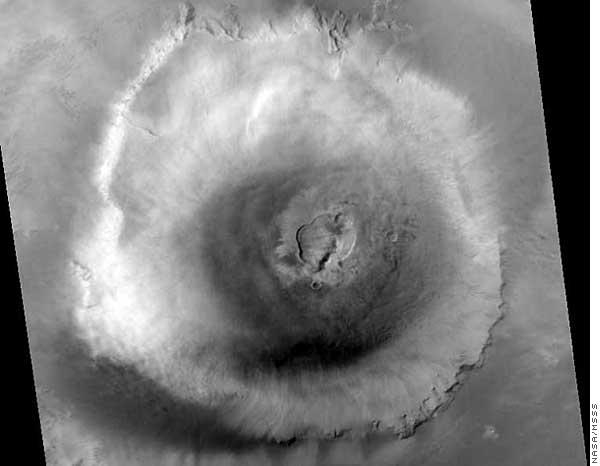
One potential candidate for such erosive signatures is Olympus Mons itself. Olympus Mons rises some 24 kilometers high and measures 550 km in diameter, making it the largest shield volcano in the solar system. According to our model, a significant portion of this volcano most likely stood above the water-line of this ancient “Tharsis Ocean,” and should still display signs of aeolian wave action.
Figure 13 Olympus Mons 3D perspective image showing prominent vertical scarp at the base of the lower flanks (NASA).
Remarkably, Olympus Mons is almost completely encircled by a very steep, nearly vertical escarpment. This scarp ranges from between 2-10 km high,27 indicating that it was carved out over time as the volcano was pulled/pushed upward by the continuing tidal force of Planet V aiding internal planetary uplift. The vertical walls of the scarp suggest that it was created by this proposed aeolian wave action, as it bears a strong resemblance to similarly vertical, wind/wave action features on Earth.
Ironically, this idea was first proposed
in a somewhat modified form in 1973, by University of Pennsylvania
geologist, the late Henry Faul. Titled romantically “The Cliff of
Nix Olympica” (the pre-Viking name for Olympus Mons), the paper was
never accepted for publication “because of the paucity of data.” 28
The Viking and MGS missions have now remedied that situation, and we
hope that Henry Faul’s remarkable idea is finally given its
appropriate hearing.
Figure 14
The White Cliffs of
Dover, a vertical, aeolian wave action feature on Earth. Further evidence that the Olympus Mons scarp feature is due to the wind-driven action of an ocean can be found in the fact that it envelops the entire mountain (Figure 15); if a hypothetical ocean surrounded such a rising tectonic feature, the wind/ocean patterns would be expected to erode a mostly uniform scarp such as the one we see.
Figure 15 Overhead view of Olympus Mons from Mars Global Surveyor. Prominent vertical scarp nearly encircles the base (NASA/MSSS).
It is also likely the scarp was formed after Mars assumed synchronous tidal lock around Planet V, since it does not appear to be a result of directional tidal forces. If the scarp was tidal, it is likely the cliffs on its circumference would be significantly more pronounced on the eastern side.
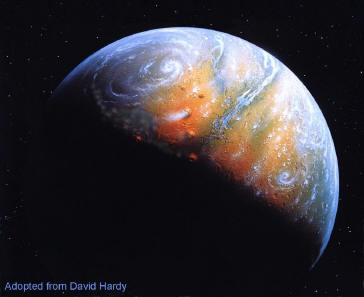
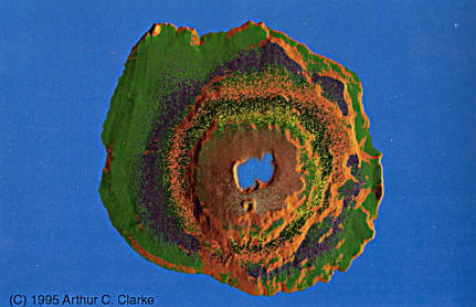
Intriguingly, Arthur Clarke several years ago created a computer-generated image (Figure 16) depicting precisely such an “Olympus Ocean.” Although projected to a time when humans have terraformed the planet Mars, his depiction – especially the waters swirling around the 22,000 foot-high cliff around the mountain – are eerily accurate to our own model of a former “tidal Mars.” 29
Figure 16 Arthur C. Clarke’s projection of an “Olympus Ocean”
lapping at the 22,000
foot-high-cliffs surround Olympus Mons
|