|

by Salah Zaimeche BA, MA, PhD
FSTC Limited
July 2002
from
MuslimHeritage Website
Introduction
The Turkish navy are famous for their endless battles fought for
Islam, from around the late eleventh
century to the twentieth, from the most further western parts of the
Mediterranean to the Indian Ocean
and the Straight of Hormuz.1 There is, however, another aspect of
Turkish naval activity, that is their
contribution to the wider subject of geography and nautical science.
This aspect, however, like much else of
Islamic science has been completely set aside. Hess puts it that
European historians were only preoccupied
with the identification of their own history. They first unravelled
‘the dramatic story of the oceanic
voyages,' their discoveries, and their commercial and colonial
empires, and only stopped to consider how
Muslim actions influenced the course of European history.
Once such
questions were answered, the study
of Islamic history became the task of small, specialized
disciplines, such as Oriental studies, which occupied
a position in the periphery of the Western historical profession.2
And the successful imperial expansion of
Western states in Islamic territories during the late nineteenth and
early twentieth centuries, Hess adds,
‘confirmed for most Europeans the idea that the history of Islam,
let alone the deeds of Ottoman sultans,
had little influence on the expansion of the West..3
Although Hess observes one or two improvements
by the time he was writing, the picture was still the
same as nearly a decade later after him, Brice and Imber in a note addressed to the Geographical
Journal, observed that although European charts of
the Mediterranean have received much focus, none
has seriously considered similar Turkish maps.4 Even
worse, European scholars have dismissed Turkish
works as being of Italian origin imported into the
Ottoman Empire, or the work of Italian renegades,
which Brice and Imber went on to demonstrate was
without any foundation of veracity.5
Turkish nautical science was much in advance of its
time, though. Hess notes that in 1517 Piri Reis
presented his famous map of the New World to the
Sultan, giving the Ottomans, well before many
European rulers, an accurate description of the
American discoveries as well as details about the
circumnavigation of Africa.6 Salman Reis, a year
later, added more onto that. Goodrich, in
a
pioneering work,7 also went a long way to correct
the overall impression, giving excellent accounts of
the Ottoman descriptions of the New World as it
was then being discovered in all its strangeness,
variety and richness.
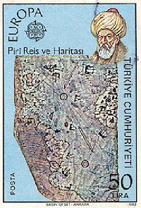
Amidst the Turkish men of the sea of great repute, Piri Reis is by
far the one with the greatest legacy. There are two entries on him
in the Encyclopaedia of Islam. The first by F. Babinger 8 and the
second by Soucek.9 By far, Soucek's entry is much richer, more
informative and competently written. That of Barbinger, also
out-dated, still offers a good variety of notes of primary sources
likely to serve a devotee or researcher.
There is a further entry on Piri Reis in the Dictionary of
Scientific Biography by Tekeli.10
Piri Reis - the Naval Commander
Piri Reis was born towards 1465 in Gallipoli. He began his maritime
life under the command of his, then,
illustrious uncle, Kemal Reis toward the end of the fifteenth and
early centuries. He fought many naval
battles alongside his uncle, and later also served under Khair eddin
Barbarossa.
Eventually, he led the
Ottoman fleet fighting the Portuguese in the Red Sea and Indian
Ocean. In between his wars, he retired to
Gallipoli to devise a first World map, in 1513, then his two
versions of Kitab I-Bahriye (1521 and 1526), and
then his second World Map in 1528-29. Mystery surrounds his long
silence from between 1528, when he
made the second of the two maps, and his re-appearing in the mid
16th as a captain of the Ottoman fleet in
the Red Sea and the Indian Ocean.11
The World Maps
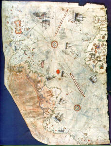
Piri Reis's first World Map in 1513, of which only one fragment is
left shows the Atlantic with the adjacent
coasts of Europe, Africa and the New World. The second World map
from 1528-29, of which about one
sixth has survived, covers the north western part of the Atlantic,
and the New World from Venezuela to
New Found Land as well as the southern tip of Greenland.
The
fragment of the first World map discovered
in 1929 at the Topkapi Museum palace, signed by Piri Reis, and dated
Muharram 919 (9 March-7 April
1513) is only part of the world of the map which the author handed
over to the Sultan Selim in Cairo in the
year 1517. The German scholar, P. Kahle, had made a thorough
analysis and description of it12, observing
that Piri Reis was an excellent and reliable cartographer.
Kahle
also points out that the whole picture of
Columbus has been distorted, as nearly all the important documents
related to him, and in particular his ship's journal, have been preserved not in their original but in
abstracts and edited works, mostly by Bishop
Las Casas.13 Long after Kahle, in the mid 1960s, Hapgood returned to
the subject of the Topkapi map,14 but
amazed by the richness of the map, and so convinced he was that
Muslim cartography was poor, he
attributed it to an advanced civilization dating from the ice age.15
Hapgood's position seems now to edge on
the ridiculous, not just for its exuberant assertions, and his
stretching of evidence to beyond the fictional,
but also in view of recent works on the history of mapping. The
recent voluminous work by Harley and
Woodward, by far the best on the subject, shows in rich detail, the
meritorious role of Muslim cartography
and nautical science.16
As for Kahle's original find, one regret he
expresses, was that the fragment found in
the Topkapi Museum was only one from an original map, which included
the Seven seas, (Mediterranean,
India, Persia, East Africa, the Atlantic Ocean, and the Red Sea),
that's the world in its vastness, and at a
very early date. The search for the other parts has remained
fruitless.17
Kitab I-Bahriye
The matter of Piri Reis' World Map, however exciting, can be the
object of a subsequent study; here, focus
will be placed on his Kitab i-Bahriye. Kahle, again, pioneered the
study of this work in two volumes.18 His
version is in German only, but there have been some very good
contributions to the subject by Soucek most
of all.19 Mantran also brought his contribution, looking at the
Kitab i-Bahriye's description of the coasts of
Algeria, Egypt, Tunisia and France.20
Esin made a good task of the
Tunisian coast,21 but on this latter
country, it is Soucek's account which really gives most
satisfaction.22 There are a few Italian contributions
by Bausani devoted to the Italian coast,23 and of specific parts of
it, the Venetian coast, the Adriatic and
Trieste.24 The Indian Ocean, too, is subject of interest.25
And
Goodrich informs that the Turkish Ministry of
Culture and Tourism has recently (1988-91) published a four volume
book of such Kitab.26 It includes a
colour facsimile of the said manuscript, each page being a
transliteration of the Ottoman text
 into the Latin
alphabet, a translation into modern Turkish, and one into English.27
Kitab I-bahriye has also aroused the
interest of archaeologists, geographers, historians, linguists.28 into the Latin
alphabet, a translation into modern Turkish, and one into English.27
Kitab I-bahriye has also aroused the
interest of archaeologists, geographers, historians, linguists.28
There are two versions of the Kitab. The first dates from 1521 and
the second from five years later. There
are many differences between the two. The first was primarily aimed
for sailors, the second, on the other
hand, was rather more a piece of luxury; which Piri Reis offered as
a gift to the Sultan. It was endowed
with craft designs, its maps drawn by master calligraphers and
painters, and even seen by wealthy
Ottomans of the sixteenth as an outstanding example of bookmaking.29
For a century or more manuscript
copies were produced, tending to become ever more luxurious, prized
items for collectors and gifts for
important people.30 Its luxury aspect apart, this version also gives
good descriptions of matters of maritime
interest such as storms, the compass, portolan charts, astronomical
navigation, the world's oceans, and the
lands surrounding them.
Interestingly it also refers to the European
voyages of discovery, including the
Portuguese entry in the Indian Ocean and Columbus's discovery of the
New World.31 This version also
includes two hundred and nineteen detail charts of the Mediterranean
and Aegean seas, and another three
of the Marmara Sea without text.32
There are around thirty manuscripts of the Kitab al-Bahriye
scattered all over libraries in Europe. Most manuscripts (two third)
are of the first version. Soucek gives an excellent inventory of the
location and details of both versions,33 amongst which are the
following:
First version:
• Istanbul Topkapi Sarayi, Bibliotheque, ms Bagdad 337
• Istanbul Bibliotheque Nuruosmaniye, ms 2990
• Istanbul Bibliotheque Suleymaniye, ms Aya Sofya 2605
• Bologna, Bibliotheque de l'Universita, collection marsili, ms
3612.
• Vienna, Nationalbibliothek, ms H.O.192.
• Dresden, Staatbibliothek, ms. Eb 389.
• Paris, Bibliotheque nationale, suppl.turc 220.
• London, British Museum, ms. Oriental 4131.
• Oxford, Bodleian library, ms Orville X infra.
• USA, private collection.
2nd version:
• Istanbul, Topkapi sarayi, Bibliothque, ms. Hazine 642.
• Istanbul, Bibliotheque Koprulu Zade fazil Ahmad pasa, ms. 171.
• Istanbul, Bibliotheque Suleymaniye, ms Aya Sofya 3161.
• Paris Bibliotheque nationale suppl. Turc 956.
Nautical instructions in Kitab I-Bayrye
Translation of the
Kitab: The Portulan
Kitab-i balhriye translated by Hess as Book of Sea Lore,34 is what
is commonly known as a portulan, i.e. a
manual for nautical instructions for sailors, to give them good
knowledge of the Mediterranean coast,
islands, passes, straits, bays, where to shelter in face of sea
perils, and how to approach ports, anchor, and
also how provides them with directions, and precise distances
between places.35
It is the only full portolan,
according to Goodrich of the two seas (Mediterranean and Aegean
Seas) ever done, and caps both in text
and in charts over two hundred years of development by Mediterranean
mariners and scholars.36 Whilst
Brice observes that Kitab-I Bahriye provides,
‘the fullest set known
to us of the kind of large scale detailed
surveys of segments of coast which, by means of joining overlaps and
reduction to a standard scale, were
used as the basis for the standard Mediterranean Portolan
outline.' 37
And in his introduction, Piri Reis
mentions that he had earlier designed a map of the world which deals
with the very recent discoveries of
the time, in the Indian and Chinese seas, discoveries known to
nobody in the territory of the Rum.38
He also
gives reasons for making his compilation:39
‘God has not granted the possibility of mentioning all the
aforementioned things (i.e cultivated and ruined places, harbours
and waters around the shores and islands of the Mediterranean, and
the reefs and shoals in the water) in a map since, when all is said
and done, [a map] is a summary. Therefore experts in this science
have drawn up what they call a ‘chart' with a pair of compasses
according to a scale of miles, and it is written directly on to a
parchment.
Therefore only three points can fit into a space of ten
miles, and there are places of less than ten miles. On this
reckoning only nine points will fit into a space of thirty miles. It
is therefore impossible to include on the map a number of symbols,
such as those showing cultivated and derelict places, harbours and
waters, reefs and shoals in the sea, on what side of the
aforementioned harbours they occur, for which winds the harbours are
suitable and for which they are contrary, how many vessels they will
contain and so on.
If anyone objects, saying, ‘Is it not possible to put it on several
parchments?' the answer is that the parchments would become so big
as to be impossible to use on board ship. For this reason,
cartographers draw on a parchment a map, which they can use for
broad stretches of coast and large islands. But in confined spaces
they will a pilot..
And whilst Piri Reis notes that his
Kitab will supply enough good
detail to obviate the need for a pilot, this
passage also shows his familiarity with small scale portolans of the
Mediterranean, his kitab being designed
to overcome their shortcomings.40
The contents of Kitab-I Bahriye are organized in chapters, 132 of
them in the first version, and 210 in the
second. Each is accompanied by a map of the coast or the island in
question. In Harley's, alongside
Soucek's article, are beautiful maps and charts of the island of
Khios, the Port of Novograd, the city of Venice, the Island of
Djerba etc.41 It was, indeed, Piri Reis.s recurrent emphasis that
text and map complement each other.42
In places, Piri Reis follows
his predecessors that include Bartolomoeo della Sonetti (himself
having found inspiring himself in previous Islamic sources). On the
whole, though, Piri Reis brings many improvements.43 The copy at the
Walters Art gallery of Baltimore in the USA (W.658), which includes
sixteen supplemental maps, attracts much focus by Goodrich.44
Description of
the Mediterranean Coasts
Maps
one, two, three and four bear an extraordinary beauty, and map three
(f.40b) World Map in a Double Hemisphere, appears in no other
manuscript. Furthermore, this map, Goodrich observes,45 is very
similar to the ‘Mappe Monde.. of 1724 by Guillaume de L.Isle.46 Map
Four (f.41ª) is the Oval World Map with the Atlantic Ocean in the
Center.
Goodrich also notes47 that a later map (from 1601), Arnoldo di
Arnoldi's two sheet world map, an oval
projection called ‘Universale Descrizione Del Mondo' is almost
exactly the same as Piri Reis..48
The wealth of information in Kitab I-Bahriye is articulated in the
series of articles on the Mediterranean coasts. The French coast ,49
here briefly summarized, includes four maps, and delves on some
important locations such as the city of Nice, or Monaco, which Piri
Reis observes, offers good possibilities for anchorage. Marseilles,
its port and coastline, receive greater focus; and from there, it is
said, French naval expeditions are organized and launched.
The
Languedoc region, from Cape of Creus to Aigues Mortes, is
inventoried in every single detail, too: its coastline, water ways,
ports, distances, and much more. Kitab I-Bahriye thus offering, not
just accurate information to sailors, but also pictures of places of
times long gone to readers and researchers.
The southern shores of the Mediterranean, however, capture even
greater focus. They were the natural
base of the Turks led by Kemal rais, and amongst whom was also Piri
Reis. The description of the Tunisian
coast, in particular, deserves thorough consideration. Mantran's 50
study although adequate is less worthy
than Soucek's, which is here relied upon.51
Soucek uses the term
Tunisia but recognizes that Ifriqyah is
more correct (note 16, p. 132) as the focus stretches from Bejaia (today's
Algeria in the West) to Tripoli
(Libya) in the east. At the time, though, both places were under the
Hafsid dynastic rule.
The Muslims of
North Africa, as a rule, welcomed the Turks not as aliens but as
allies (p. 130.) At the time, the inhabitants
of North Africa were, indeed, under constant threat of attacks by
European pirates, who often came
disguised as Muslims in order to capture Muslims (note 4, p. 161).
Turkish seamen used those southern
shores to rest between their expeditions to the north and to the
West, and often wintered in one of the
harbors or islands, and this is how Piri Reis became familiar with
these shores (p. 130).52 First describing Bejaia, he states that it was a handsome fortress situated on a pine
tree covered mountain slope with one
side on the shore. The city's ruler was called Abdurrahman, related
to the Sultan of Tunis, a family
descendant from Ommar Ibn al-Khatab, he holds (p.149).
He observes
that among all the cities of the
Maghreb, none would offer a spectacle comparable to it. Piri Reis
must have seen the Hammadite palaces
and was so impressed by them before they were destroyed by the
Spaniards when they took the city (note
2 page 160). When the Spaniards, indeed, took the city in 1510, they
forced the population to flee to the
mountains, settled part of it, and razed the rest (p.151).53
Piri
Reis moves onto Jijel and the region around,
noting that it was under the rule of Bejaia (prior to the Spanish
take over), under the protection of Aroudj
Barbarosa (p. 157). Further to the east, his attention is caught by
Stora, (now part of Skikda), its ruined
fortress, and the large river which flows in front of its harbor,
its water, he notes, tasting like that of the
Nile. Before crossing into today's Tunisia, Piri Reis notes the
presence of lions in the Bone (Annaba) region
(p.169), people often falling victims to their hunger.54
Piri Reis
begins his exploration of Tunisia proper with
Tabarka, drawing attention that safe anchorage is on the western
side, where it was navigable, and water
deep enough. South of the island of Calta (Galite), he notes great
danger when southern winds blow. The island, he points out has
exceptionally good quality water ‘tasting of rose-water,. (p.177),
and includes innumerable flocks of wild goats.55 Bizerte, on the
other hand, impresses for its sturdy fortress, its good port for
anchorage, and abundance of fish (p.185).
Further on, at Tunis,
great interest is in its climate, commerce, its rulers and their
rivalries. The city has fifty thousand houses, each ‘resembling a
sultan's palace. (p.197), and orchards and gardens fringe the city.
In each of these gardens, were villas and kiosks, pools and
fountains, and the scent of jasmine overpowering the air. There were
water wheels, too, and so many fruit people hardly paid any
attention to them.
The city was visited by Venetians and
Genoese
traders, their ships loading with goods before departing; their site
of anchorage in the port nine miles in front of the city (p.197).
The harbor of Tunis itself is a bay which opens toward the north,
and anchorage, he points out, is seven fathoms deep, the bottom
even, and the holding ground good. Further safety of the port is
secured from enemy fleets by the means of a tower with a canon
guarding it (p.199).
To Cape Cartage, also called cape Marsa,
uninterrupted anchorage is secure, and ships can winter all over the
ports. Danger lies, however, in the vicinity of the island of Zembra,
which is exposed most particularly to southerly winds, whilst rocks
often covered by water (p 201) can be very treacherous. Along the
Hammamet coast, the sea has shallow waters, an even bottom and white
sand. The depth in the open sea, one mile offshore, is four to five
fathoms. (p. 219).
Continuing to Sousse, he points to the large
fortress on the coast facing the North east; in front of it is a
harbor built by ‘infidels.; a man made breakwater, as in the Khios
harbor, protecting it on the outer side. Water, however, is too
shallow for large vessels (p.221). The island of Kerkena offers
excellent anchorage conditions regardless of the severity of the sea
storms; hence an ideal place for wintering (p.235). The same goes
about Sfax. Around Kerkenna, however, he notes, is the constant
threat of European pirates, especially where waters are deep enough
to allow the incursion of their large boats.
The island of Djerba, of all places, is what attracts most attention
(pp 251-267). Piri Reis goes into the
detail of its people, history, customs, economy, and, of course, of
the sailing conditions close and around
the island, including anchorage, nature of currents, tides, and
risks to sailors.
The focused attention on
Djerba is the result of his earlier experiences, when, with his
uncle Kemal, he conducted rescues of Muslim
and Jewish refugees as they were being cleansed out of Spain
following the Christian Re-conquest.56 Now
entering Libya, he is focus falls on Tripoli (pp. 273-285), its
history, commerce, and its thriving port. He
indicates how to sail there using a mountain as landmark.
Anchorage
at the city port is good, he notes,
three islets on the northern side of the harbor, cutting down the
wind velocity. By that time he is describing
the city, though, it had already fallen into Spanish hands,
something that aggrieved him so much. It was
the loss of the place, of course, that of fellow companion seamen,
and above all the destruction of the city
fortress that compounded such grief.
He notes (p.273) that,
in the Maghreb, no fortress was as handsome
as Tripoli's, all its towers and battlements as if cast from bee's
wax, and the walls painted in fresh lime. The
fortress had fallen on July 25, 1510; and so much joy there was in
Spain as in the rest of Christendom, that
Pope Julius II went on a procession of thanks giving.57
References
1 See For instance:
-M Longworth Dames: The Portuguese and Turks in the Indian Ocean in
the 16th century in Journal of the
Royal Asiatic Society, 1921, pp 1-28.
-D.Ross: The Portuguese in India and Arabia between 1507 and 1517,
in Journal of the Royal Asiatic
Society 1921, pp 545-62.
-D. Ross The Portuguese in India and Arabia 1517-38; in Journal of
the Royal Asiatic Society, 1922; pp
118.
2 A.C. Hess: The Evolution of the Ottoman Seaborne Empire in the Age
of Oceanic Discoveries, 1453-1525;
The American Historical Review,Vol 75, 1969-70, pp 1892-1919, at p.
1892.
3 Ibid.
4 W.Brice, and C. Imber: Turkish Charts in the Portolan Style, The
Geographical Journal, 144 (1978); pp
528-529 at p. 528.
5 Ibid.
6 A.C. Hess: The evolution, op cit, p. 1911.
7 T.D. Goodrich: The Ottoman Turks and the New World; Wiesbaden ,
1990.
8 F. Babinger: Piri Reis, in Encyclopaedia of Islam, first edition
(1913-30), vol vi; Leiden. E.J. Brill, pp 10701
9 S. Soucek: Piri Reis, in Encyclopaedia of Islam, New edition,
1995, Vol VIII, Leiden, Brill, pp 308-9.
10 S. Tekeli: ‘Piri Reis. in Dictionary of Scientific Biography, vol
10; Editor C.S. Gillispie, Charles Scribner's
Sons, New York, 1974, pp 616-9.
11 S.Soucek: A Propos du livre d.instructions nautiques de Piri
Reis, Revue d.Etudes Islamiques, Vol 41, pp
241-55, at p. 242.
12 P. Khale : Die verschollene Columbus-Karte von 1498 in einer
turkishen Weltkarte von 1513, Berlin, 1933.
In English: P. Kahle: The Lost map of Columbus.
13 Ibid; introduction.
14 C. Hapgood: Maps of the Ancient sea Kings, Philadelphia, 1966.
15 Ibid, p.
16
J.B. Harley and D. Woodward: The History of Cartography, (vol two,
book one: cartography in the
traditional Islamic and South Asian societies;) The University of
Chicago Press, Chicago London, 1992.
17 P. Kahle: The lost, op cit, p.4.
18 P. Kahle: Piri Reis, Bahriye, Berlin 1926, 2 vols.
19S. Soucek: A propos, op cit.
-S. Soucek: Islamic Charting of the Mediterranean; in J.B. Harley
and D. Woodward edt: History, op cit, vol
2, book one, pp 263-92.
20 Robert Mantran: La Description des cotes de l.Algerie dans le
Kitab-I Bahriye de piri Reis, in Revue de
l.Occident Musulman (ROM), Aix en Provence, Vol 15-16, 1973; pp
159-68.
- R. Mantran: La Description des cotes de la Tunisie dans le Kitab I-Bahriye
de Piri Reis, ROM, 23-24
(1977), pp 223-35.
- R. Mantran: Description des cotes Mediterraneene de la France dans
le Kitab I Bahriye de Piri Reis, ROM,
vol 39 (1985); pp 69-78.
-R. Mantran: La Description des cotes de l.Egypte de Kitab I-Bahriye:
Annales Islamologiques, 17, 1981 pp.
287-310.
21 E. Esin: La Geographie Tunisienne de Piri Reis, in Cahiers de
Tunisie, 29, (1981), pp. 585-605.
22 S.Soucek: Tunisia in the Kitab-I Bahriye of Piri Reis, Archivum
Ottomanicum, Vol 5, pp 129-296.
23 Bausani A: L.Italia nel Kitab I-Bayriye di Piri Reis, Il Vetro,
23 (1979), pp 173-96.
24 Bausani A: Venezia e l.Adriatico in un portolano Turco, Venezia e
l.Oriente a cura di L.Lanciotti; Florence:
Olschki, 1987, pp 339-52.
Bausani. A: La Costa Muggia-Triesto-Venezia nel portolano (1521-27)
di Piri Reis, Studi Arabo-Islamici…
a cura di C. Sarnelli Lergua. Naples: Istituto Universitario
Orientale, 1985, (1988); pp 65-9.
25 Allibert. C: Une Description Turque de l.Oceon Indien au XVIem
Siecle: L.Ocean indien Occidental dans le
Kitab-I Bahriye de Piri Reis; Etudes Ocean Indien, 10 (1988); pp
9-51.
26 Thomas.D. Goodrich: Supplemental maps in the Kitab-I bahriye of
Piri Reis, in Archivum Ottomanicum,
Vol 13 (1993-4), Verlag, Wiesbaden, pp 117-35.; at p. 119.
27 Kitab-I Bahriye, Piri Reis, 4 vols, ed., Ertugrul Zekai Okte,
trans, Vahit Cabuk, Tulay Duran, and Robert
bragner, Historical research Foundation-Istambul Research Centre
(Ankara: Ministry of Culture and Tourism
of the Turkish Republic, 1988-91)
28 P. Kahle: the Lost, op cit, p,
2
29 T.Goodrich: Supplemental, op cit, at p.116.
30 Ibid, p. 117.
31 S. Soucek: Islamic Charting, op cit, at p. 272.
32 T. Goodrich: Supplemental, op cit, p.117.
33 A. Soucek,, A propos, op cit, pp 244-5.
34 A.C. Hess: The Evolution, op cit.
35 S. Soucek: A propos, op cit, pp 242.
36 T. Goodrich: Supplemental, op cit, at p.117.
37 W. Brice: Early Muslim Sea-Charts, in The Journal of the Royal
Asiatic Society, 1977, pp 53-61, at p.56.
38 P. Kahle: The Lost, op cit, p. 2.
39 Derived from W.Brice-C. Imber: Turkish Charts, op cit, p 528.
40 Ibid, p.529.
41 S. Soucek: Islamic, op cit,, pp 277-80.
42 Ibid at 277.
43 See fig 1 in W. Brice: early Muslim sea-charts, op cit, at p. 57
44 T.Goodrich: Supplemental, op cit, p. 120.
45 T.Goodrich, Supplemental, op cit, p.122.
46 See R.V. Tooley: French mapping of America, London: Map
Collector.s Circle, 1967.
47 T.Goodrich: Supplemental, op cit, p.122.
48 See Rodney W.Shirley: The Mapping of the World, Early Printed
World maps, 1472-1700; London; The
Holland Press, 1984, no 228 and plate 180.
49 R.Mantran: Description des cotes Mediterranneenes de la France,
op cit.
50 R. Mantran: La Description des cotes de la Tunisie. op cit.
51 S.Soucek: Tunisia in the Kitab-I Bahriye of Piri Reis, Archivum
Ottomanicum, Vol 5, pp 129-296.
52
With respect to this ‘Tunisian. coast, Soucek notes, it is the first
version of the Kitab which is much
richer than the second.
53 Bejaia was to be retaken forty five years later, in 1555 by Salah
Reis, beylerbey of Algiers, but following
the Spanish entry, it never regained its former glory.
54 In 1891, the French killed the last lion of North Africa between
Bone and Bizerte (Tunisia) (Note 5, p.
180. Source in Soucek: L. Lavauden: La Chasse et la faune
cynegetique en Tunisie, Tunis, 1924, p. 9.
55 That is until the French exterminated them all (Lavauden, op cit,
pp 18-19.)
56 S. Soucek: Islamic Charting, op cit, p 267.
57
Note 8, p. 287 in Soucek., Source Sanuto Diarii, v, fol.109.
The city was retaken from the Spaniards in 1551 by Sinan Pasha and
Turgut.
Bibliography
-C.Allibert. C: Une Description Turque de l.Ocean Indien au XVIem
Siecle: L.Ocean indien Occidental dans le
Kitab-I Bahriye de Piri Reis; Etudes Ocean Indien, 10 (1988); pp
9-51.
-F. Babinger: Piri Reis, in Encyclopaedia of Islam, first edition
(1913-30), vol vi; Leiden. E.J. Brill, pp 1070
1.
-A. Bausani: L.Italia nel Kitab I-Bayriye di Piri Reis, Il Vetro, 23
(1979), pp 173-96.
-A.Bausani: Venezia e l.Adriatico in un portolano Turco, Venezia e
l.Oriente a cura di L.Lanciotti; Florence:
Olschki, 1987, pp 339-52.
-A.Bausani: La Costa Muggia-Triesto-Venezia nel portolano (1521-27)
di Piri Reis, Studi Arabo-Islamici…
acura di C. Sarnelli Lergua. Naples: Istituto Universitario
Orientale, 1985, (1988); pp 65-9.
-W.Brice, and C. Imber: Turkish Charts in the Portolan Style, The
Geographical Journal, 144 (1978); pp
528-529.
-W. Brice: Early Muslim Sea-Charts, in The Journal of the Royal
Asiatic Society, 1977, pp 53-61.
-E. Esin: La Geographie Tunisienne de Piri Reis, in Cahiers de
Tunisie, 29, (1981), pp. 585-605.
-T.D. Goodrich: The Ottoman Turks and the New World; Wiesbaden ,
1990.
-Thomas.D. Goodrich: Supplemental maps in the Kitab-I bahriye of
Piri Reis, in Archivum Ottomanicum, Vol
13 (1993-4), Verlag, Wiesbaden, pp 117-35.
-C. Hapgood: Maps of the Ancient sea Kings, Philadelphia, 1966.
-J.B. Harley and D. Woodward: The History of Cartography, (vol two,
book one: cartography in the
traditional Islamic and South Asian societies;) The University of
Chicago Press, Chicago London, 1992.
-A.C. Hess: The Evolution of the Ottoman Seaborne Empire in the Age
of Oceanic Discoveries, 1453-1525;
The American Historical Review,Vol 75, 1969-70, pp 1892-1919.
-P. Khale : Die verschollene Columbus-Karte von 1498 in einer
turkishen Weltkarte von 1513, Berlin, 1933.
In English: P. Kahle: The Lost map of Columbus.
-P. Kahle: Piri Reis, Bahriye, Berlin 1926, 2 vols.
-M Longworth Dames: The Portuguese and Turks in the Indian Ocean in
the 16th century in Journal of the
Royal Asiatic Society, 1921, pp 1-28.
-Kitab-I Bahriye, Piri Reis, 4 vols, ed., Ertugrul Zekai Okte,
trans, Vahit Cabuk, Tulay Duran, and Robert
bragner, Historical research Foundation-Istambul Research Centre
(Ankara: Ministry of Culture and Tourism
of the Turkish Republic, 1988-91).
-L. Lavauden: La Chasse et la faune cynegetique en Tunisie, Tunis,
1924.
-R. Mantran: La Description des cotes de l.Algerie dans le Kitab-I
Bahriye de piri Reis, in Revue de
l.Occident Musulman (ROM), Aix en Provence, Vol 15-16, 1973; pp
159-68.
-R. Mantran: La Description des cotes de la Tunisie dans le Kitab I-Bahriye
de Piri Reis, ROM, 23-24 (1977),
pp 223-35.
-R. Mantran: Description des cotes Mediterraneene de la France dans
le Kitab I Bahriye de Piri Reis, ROM,
vol 39 (1985); pp 69-78.
-R. Mantran: La Description des cotes de l.Egypte de Kitab I-Bahriye:
Annales Islamologiques, 17, 1981 pp.
287-310.
-D.Ross: The Portuguese in India and Arabia between 1507 and 1517,
in Journal of the Royal Asiatic
-D. Ross The Portuguese in India and Arabia 1517-38; in Journal of
the Royal Asiatic Society, 1922; pp
118.
-Sanuto Diarii, v, fol.109.
-Rodney W.Shirley: The Mapping of the World, Early Printed World
maps, 1472-1700; London; The Holland
Press, 1984, no 228 and plate 180.
-S. Soucek: Piri Reis, in Encyclopaedia of Islam, New edition, 1995,
Vol VIII, Leiden, Brill, pp 308-9.
-S.Soucek: A Propos du livre d.instructions nautiques de Piri Reis,
Revue d.Etudes Islamiques, Vol 41, pp
241-55.
-S. Soucek: Islamic Charting of the Mediterranean; in J.B. Harley
and D. Woodward edt: History, op cit, vol
2, book one, pp 263-92.
-S.Soucek: Tunisia in the Kitab-I Bahriye of Piri Reis, Archivum
Ottomanicum, Vol 5, pp 129-296.
-S. Tekeli: ‘Piri Reis. in Dictionary of Scientific Biography, vol
10; Editor C.S. Gillispie, Charles Scribner's
Sons, New York, 1974, pp 616-9.
-R.V. Tooley: French mapping of America, London: Map Collector.s
Circle, 1967.
|
