|

|
Below, Color Map
of the southern east coast of Argentina curved sideways.
The
area in the square below coincides geographically with the land contours at
the bottom of the Piri Reis map (right) underlined in red.
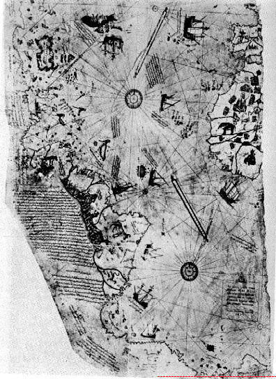
Piri Reis map
shows a correct and continuous shoreline along the north and east coast of
South America.
One can see the Amazon, and then past the “hub” of Brazil one
can follow the shoreline down to the river with three heads (Rio Plata) and
then follow it along Argentina, where, on the Piri Reis map, the
cartographer bent it eastward to keep it on the paper.
For some odd reason
some have claimed this is Antarctica before the ice age, indicating the map
is based on prehistoric originals.
This would mean Antarctica is in the
South Atlantic, connected to Uruguay, and that there is no Argentina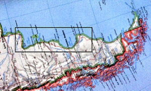
Possibly some of the wildest assertions made for a prehistoric
super civilization, for an Atlantean world culture, or for ancient UFO
visitations of the Earth, are on behalf of the Piri Reis Map,
a map made in 1513 for an “Amir al bar” (Admiral) of the
Turkish Navy. |
 |
This map was found
when Topkapi Palace in Istanbul, the former residence of the deposed
Sultans, was being converted into a museum in 1929.
The
Ancient Astronaut theory was popularized by
Erich von D�niken in his
Chariots of the Gods, 1969.
Von D�niken observed:
“The maps are absolutely
accurate . . .The coasts of North and South America and even the contours of
the Antarctic were also precisely delineated on Piri Reis’ maps. The maps
not only reproduced the outlines of the continents but also showed the
topography of the interiors!
. . .The latest studies of
Professor Charles H. Hapgood and mathematician
Richard W. Strachan give us some more shattering information. Comparison
with modern photographs of our globe taken from satellites showed that the
originals of the Piri Reis maps must have been aerial photographs taken from
a very great height.”
Charles Berlitz added the
Atlantean connection in
The Bermuda Triangle in
1974.
“The Piri Reis Map found in Istanbul in 1929, part of a world map said
to have been copied from a Greek original in the Library of Alexandria.
Among other features, the Piri Reis map shows detailed features of
Antarctica evidently drawn several thousand years before
Antarctica was
“discovered,” as well as the true shape of Antarctica without the covering
ice.
Other features indicate an advanced knowledge of astronomy,
trigonometry, and the ability to determine longitude, not known to our
culture until the reign of George III of England.”
Many books and magazines have echoed such ideas. Again, as late as 1995 in
his Finger Print of the Gods, Graham Hancock used the Piri Reis Map as
evidence for the possibility of a prehistoric supercivilization.
He said:
“...the true enigma of this 1513 map is not so much its inclusion of a
continent not discovered until 1818 [Antarctica] but its portrayal of part
of the coast line of that continent under ice free conditions which came to
an end 6,000 years ago and have not since recurred.”
Again, as with the Buache Map, all of those above could extend some
scientific credibility to their points of view from the 1965 work of Prof.
Charles Hapgood, in his Maps of the Ancient Sea Kings, in which he
postulated the map was drawn not only from Greek maps of 400 B.C., but from
much older maps as well, preceding 4,000 B.C. in that nebulous era of
“prehistory” before our culture’s records begin in
Sumeria and
Egypt.
However, the extent that pseudo science has taken his work, and added
thereto is incredible. Hapgood himself had some very novel theories, for
which he was ridiculed.
In fact, the Piri Reis map was made in 1513, as the map itself says in
Turkish. It does not show Antarctica at all. The land mass at the bottom of
the map is so obviously connected to South America because it is South
America. One can follow the coast line of South America quite well. The
cartographer merely bent it around to keep it on the same swatch of paper.
As for the advanced astronomy and trigonometry: this myth comes from von D�niken’s believe that the curving of South America at the bottom of the map
indicates that this was a copy of an ancient satellite photo taken over
Cairo, from which vantage point South America would look distorted and
curved. Hapgood himself had said that the Andes drawn on the map showed they
were mapped from sea-level. To top it off, von D�niken did, on one occasion,
renounce his point of view but then retracted his retraction again.
Graham Hancock’s use of the map is the most surprising, since long before
the 1990s von D�niken’s ideas, including those on the Piri Reis map, had
been soundly countered by Dr. Clifford Wilson’s Crash Go The Chariots and
Ron Story’s Space Gods Revealed.
Von D�niken’s research methods themselves
were scrutinized by the German magazine Der Spiegel, culminating in their
stunning expos� of his third book Gold of the Gods, in which von D�niken
claimed to have been taken through a maze of deeply buried tunnels in
isolated Ecuador by distinguished local scientist Juan Moricz.
Von D�niken records:
“We slid down a rope to the first platform 250 feet
below the surface. From here we made 2 further descents of 250 feet. Then
our visit to the age old underworld of a strange unknown race really began.
The passages all formed perfect right angles. Sometimes they are narrow,
sometimes wide. The walls are smooth and often seemed to be polished.
The
ceilings are flat and at times look as if they were covered with a kind of
glaze. Obviously they did not originate from natural causes - they look more
like modern air raid shelters!”
“As I was feeling and examining ceilings and walls, I burst out laughing and
the sound echoed through the tunnels. Moricz shone his torch on my face:
“What’s wrong? Have you gone crazy?”
“I’d like to see the archeologist with the nerve to tell me that this was
done with hand axes!”
Von D�niken went on to describe all sorts of anachronisms: unusual gold
trinkets, seven chairs of what seemed to be plastic, and thousands of metal
tablets which might have contained the sum total of humanity’s prehistory.
Der Spiegel traveled to Ecuador and asked
Juan Moricz. In response to Der
Spiegel’s question:
“Mr. Moricz, in his most recent book,
Erich von D�niken
claims to have descended with you into a secret cave world in Ecuador,”
Moricz replied “D�niken has never been in the caves– unless it was in a
flying saucer.”
According to Moricz,
D�niken pulled the information out of him after hours
of grilling him about all the local legends of the caves.
|

Der Spiegel’s November 12, 1973 issue. The German requires no translation. |
Der Spiegel’s November 1973 issue (left) sums up their findings. “The
D�niken Swindle.”
There is nothing remarkable in the Piri Reis map regarding ancient
UFO
pictures. Those who have promoted this notion have consistently shown
themselves unreliable. Or what is the modern vernacular? “honesty
challenged.”
As regards supercivilization or Atlanteans, there is even less evidence. The
contours of the Piri Reis map hardly show itself to be a photographic copy
or even a high skilled map drawn by Atlanteans— the whole Gulf of Mexico and
Cuba are absent.
As the map above by the Reis map
shows, there is no Antarctic, so there is no pre 6,000 year old charting
evidence on the map.
However, I’ve found that the Piri Reis Map does show something that is quite
surprising and unexpected, something that makes it relevant to the study of
the Bermuda Triangle and the Cayce Atlantis/Bahama Bank connection.
Following the coastline of South America northward one can easily
distinguish the Windward and Leeward islands, Puerto Rico, then the island
of Hispaniola (of which share modern Haiti and Dominican Republic).
North of
this there is a large island, which does not exists today.
This is where the Great Bahama Bank is now submerged. Now, cartographers often marked areas on maps with
something distinctive, like a type of bird, sometimes cannibals, unique
animals, lamas, elephants, etc., anything to indicate a dominant feature of
that region. It is fascinating that this large island is marked by a row of
huge polygonal stones not unlike those off Bimini! (See the blowup below
left.)
 This makes one wonder just how long the
Bahama Banks have been underwater if
during the time of Columbus the great stones could easily be seen as a
salient feature of land on this island. They rest under only 18 feet of
water today. This makes one wonder just how long the
Bahama Banks have been underwater if
during the time of Columbus the great stones could easily be seen as a
salient feature of land on this island. They rest under only 18 feet of
water today.
Since the Gulf Stream was used as a main conveyor back to
Spain, the Spanish came across Bimini very early on. Thus these probably are
the
Bimini stones, meaning the shoreline of Bimini was greater than today.
A
slow sinking of the Bahama shelf is not impossible. About 20 feet in 500 odd
years is not extraordinary. What is that? – a centimeter or so per year.
Makes you wonder who just did “discover” them, J. Manson Valentine or the
Spaniards.
Probably the latter within the first 20 years of their voyages to
the New World. If so, they did not sink thousands of years ago in a sudden
catastrophe. They are, in this case, megalithic ruins that hardly represent
anything a la the ambiguous readings of
Edgar Cayce.
It may have been
Columbus himself. His map of the New World later
disappeared, and has gone down in lore as the “lost map of Columbus.”
The Piri Reis map is marked in the margin that it came from a map
Columbus drew
himself. The earliness of the Piri Reis’ map seems probable since Cuba, the
Gulf, and other more westerly areas do not appear on the map.
All of what its pseudoscientific promoters have claimed or suggested is
clearly wrong, even ludicrous! The idea Antarctica is on the bottom of the
map so lacks any logic as to be scary. There is far more evidence and
inconsistencies in archeology to suggest a much more advanced prehistory
than we at first imagine. But the search for this fascinating part of our
species’ past is wounded by fanciful “eager believers” trying to find “holy
relics” for their preconceived ideas.
They either lack the scientific
discipline to pursue their goal, or they outright disregard it.
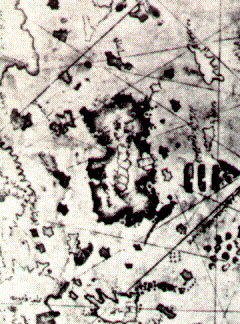 The
Island of Hispaniola can clearly be distinguished by its shape at the
very bottom of the blowup right. Down the center of the big island north of
it, in the center of the blowup, are huge polygonal stones lying prostrate. The
Island of Hispaniola can clearly be distinguished by its shape at the
very bottom of the blowup right. Down the center of the big island north of
it, in the center of the blowup, are huge polygonal stones lying prostrate.
A few form a bulwark on the east coastline. Is this island Bimini, greatly
exaggerated in size and disproportional? Or were the Bahamas about 20 feet
higher than today, so that it was an archipelago of several large islands?
If so, the Bimini stones, merely .5 mile or so from the coastline today,
would have been above water in the time of Columbus. Old records in Madrid
may hold the key.
Perhaps a Spanish captain made comment on the strange
stones which caused them to be considered a salient feature for the map
maker of this mysterious island on the Piri Reis map.
On the map, in a marginal note, it states it is based on a map drawn by
Columbus himself. If this was the “lost map of Columbus,” whose mysterious
disappearance was never solved, than the Piri Reis Map is the oldest map of
the Americas... and Bimini was already considered unusual.
In his Stones of Atlantis, Dr. David Zink notes that the original
inhabitants of the Bahama area in Columbus’ times were very much like the
Taino tribe of Haiti.
In 1645 Father Breton translated much of their
language. Bimini meant “Island of the old wall,” or “old ruins”— perhaps an
indication that the Bimini wall was above water at the time or within recent
memory.
If so, its purpose has long been mysterious.
|