|
Chapter 7
Heaven & Hell
The “Celestial City” mentioned in the description of
Mount Olympus
is the docked and tethered Planet X Nibiru, as Hyperborea, above or
“hyper”/beyond our North Pole (“borea”). The actual Mount Olympus in
Greece, which I have seen myself, is merely a geographical
substitute, a symbolic remembrance, of the true celestial Mount
Olympus, Abode of the Gods.
The information provided by Madame Helena P. Blavatsky and Sir E.A.
Wallis Budge about the physical descriptions of “Mount Meru” and
“Tuat” undoubtedly are ancient attempts to describe the different
celestial environments of the Northern and Southern Hemispheres
during the 900 years that Nibiru is anchored beyond the North. Given
the primitive technological capabilities of ancient observers, one
must always take such descriptions with the proverbial grain of
salt; however, we can extrapolate certain possibilities from what
they tell us. “Heaven” is traditionally thought to be “up there in
the sky”; the sky-vault itself is often referred to as “the
heavens”. When we think of “Heaven”, we think of something up above
us in the sky. But since there is no visible “Heaven” in our sky
today, we quaintly imagine that it is “somewhere”.
One time the
wacky Weekly World News had a banner front-page headline blaring
that the Hubble Space Telescope had discovered “Heaven”! They
featured a picture of some “cosmic object” and described this
“Heaven” in great detail, all of which was spurious, of course, but
which serves nevertheless to underline the fact that “Heaven” is
considered by most people to be “up in the sky” somewhere. By
contrast, “Hell” is conceived as a nether region, an “Underworld”.
Some Christians, for example, believe that the righteous souls will
pass by the right hand of God into Heaven, whilst the sinners are
led past his left hand into the pits of brimstone and lakes of fire
of Hell, which is ruled by a Devil, a Satan, the Fallen-Archangel
Lucifer, Anubis, Hades, Pluto. It is a dark but fiery region of
fear, uncertainty and eternal punishment.
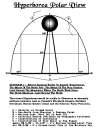
When the large Planet X Nibiru is stationary at Hyperborea (Greek
for “beyond the North”), Nailed to the North by its
Rainbow Bridge,
it would be visible as a large golden Second Sun that would dwarf in
size our regular Sun, which would almost seem like a Moon by
comparison. This “Second Sun” would, in fact, be primary. It would
be visible even during nighttime as a “Night Sun”, as
Dr. Immanuel Velikovsky has hypothesized and as we find mentioned in so many
ancient legends. But it would not be visible to those below the
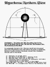
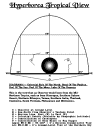
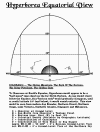
Equator, especially below the Southern Tropic Latitude. See “The Hyperborea Sky Views”.
If one were to travel south of the Equator, then one would no longer
see this Hyperborea Sun, just as even today, one cannot see the
Constellations of Ursa Major (Big Dipper) and Cassiopeia below the
Southern Tropic (or conversely, the Southern Cross from high
Northern Latitudes). Below the Equator, astronomically, the
situation would be much the same as it is today. We would have a Sun
for half the day, and a Moon on most nights. But the nights
themselves would be dark and be filled with peculiar twinkling starlights not visible in the North. There would be no “Night Sun”
to lighten up the natural environment. That is a crucial concept to
consider when reading the following material about the Egyptian “Tuat”.
If an Egyptian had grown up on the Giza Plain with a Hyperborea
Night Sun always present, travelling southwards to the Equator and
below would have meant entering a “strange land” of “darkness”,
meaning simply a different kind of “darkness” than that which would
have been experienced in the Northern Hemisphere where the regular
Sun would set and only the Hyperborea Night Sun would be visible for
the “nighttime” half of the day.
In the Finnish Creation Myth Kalevala (see
Chapter 9), it is
recorded that when the “Sampo”, or this northern “Golden Pole” had
vanished, men would try to “construct another Sampo, and another Sun
for shining, and another Moon for gleaming”; the word “Sampo” refers
to the whole structure, i.e., “the golden pole with the golden cage
on top”: the word “Sun” refers to the Planet X Nibiru
atop the
Rainbow Bridge, and the word “Moon” refers to the present
Sun, not
to the present Moon!
Madame Blavatsky makes three most revealing statements, quoting
other sources:
1—“If it may be found that the ancients knew the topography and
nature of the Arctic and Antarctic regions better than any of our
modern astronomers, they had reasons, and good ones, for naming one
the ‘Mountain’ and the other the ‘Pit’.”
2—“Helion is the Sun in the
highest” (Helios, Helion, the “most high”); “and Acheron is 32 deg.
above the pole, and 32 below it, the allegorical river being thus
supposed to touch the northern horizon in the latitude of 32
degrees. The vast concave, that is forever hidden from our sight and
which surrounded the southern pole, being therefore called the
Pit,
while observing, toward the Northern pole that a certain circuit in
the heavens always appeared above the horizon—they called it the
Mountain. As Meru is the high abode of the Gods, these were said to
ascend and descend periodically; by which (astronomically) the
Zodiacal gods were meant, the passing of the original North Pole of
the Earth to the South Pole of the heaven.”
3—“…crossing the eight coils of the Serpent… which would seem like an
imaginary
ladder with eight staves reaching from the earth up to the pole,
i.e., the throne of
Jove. Up this ladder, then, the Gods…ascended and descended.
(Jacob’s ladder and
the angels)…”
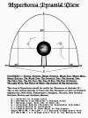
The “eight coils of the Serpent” or the
eight stairs up the ladder
to Heaven would
indicate that the sloping angle from Earth’s North Polar Region to
Nibiru’s South
Polar Region, i.e., The Rainbow Bridge, would have eight “stair-step
levels” to it, much like the tiered layers of a fir tree, a tall
sort of “Pagan Paradise Christmas Tree” with a golden star on top.
In the Northern Hemisphere the “Mountain” was visible; but in the
Southern Hemisphere, i.e., “The Pit”, it was not visible in that
“underworld land of darkness”.
Illustration 17: “Tyr[rhen]i Orum” = Pelasgian People = Etruscans
See also the Frontispiece, Illustration 17
above and Chapter 10.
If the
“Gods” ascend and descend from the South Pole of this “Mountain” to
the North Pole of the Earth, then this process of ascending and
descending, elevatorlike, must be what is indicated in the Siberian
legend of the “tomcat” climbing up and down the “golden pole” and in
the Nordic legend of the “squirrel Ratatosk” scurrying up and down
the Yggdrasill Tree.
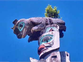 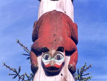
Illustration 23: Alaska Totem Pole (squirrel, tomcat or monkey?)
-
Illustration 24: Alaska Totem Pole
See Illustrations 23-24
above and Chapter 9.
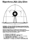
Madame Blavatsky’s reference to an object with an astronomical
radius of 32° out from the North Polar Star, or a diameter of 64°,
is extraordinary! That would be a huge object! In the Hyperborea Sky
Views, I have used only a diameter of about 23°. And in my
depiction, this object would not be visible as a “ball” floating on
the Northern Horizon until one reached the Northern Tropic
Latitudes, whereas Madame Blavatsky suggests that the “ball effect”
would be visible as far north as Beirut and Dallas, not too far
north of either Cairo/Giza and Houston. As far as I know,
Madame Blavatsky’s The Secret Doctrine is the only place where I have ever
been able to find an absolute size of this object. To be honest, as
I have stated time and again, we can only know the truth for sure
when we are able to observe scientifically this object once again,
after its next return to our “Hyperborea”. Considering, however, all
of the documented possibilities for chaos and catastrophe whenever
this object does return and retether, one can only hope that some
books such as The Secret Doctrine—and yes, this book, also—will
survive the destruction so that survivors can put two and two
together again and make some scientific sense out of these dusty
“myths” from bygone ages. It is a fascinating “problem” to
contemplate from our contemporary perspective, here immediately in
advance of the repeat of this surprise return of Heaven and Hell!
From A Dictionary of Greek and Roman Biography and Mythology,
Volume
3, p.
25,
by Professor William Smith & Others,
London, 1890.
MOUNT OLYMPUS
Olympus, the abode of the gods, also requires a few words of comment
in this place.
Mount Olympus is situated in the northeast of Thessaly, and is about
6,000 feet
high; on its summit which rises above the clouds of heaven, and is
itself cloudless,
Hephaestus had built a town with gates, which was inhabited by Zeus
and the other
gods. The palace of Zeus contained an assembly-hall, in which met
not only the
gods of Olympus, but those also who dwelt on the earth or in the
sea. The celestial
mountain must indeed be distinguished from heaven; but as the gods
lived in the city which rose above the clouds and into heaven, they
lived at the same time in heaven, and the gates of the celestial
city were at the same time regarded as the gates of heaven.
From A Dictionary Of The Bible
By Professor William Smith & Others,
Boston, 1863,
Volume I, Pages 987 & 1026-27.
JERUSALEM & MOUNT ZION
The tombs of the [Hebrew] kings were in the city of David, that is,
Mount Zion, which, as will be shown in the concluding section of
this article [on Jerusalem], was an eminence on the northern part of
Mount Moriah. The royal sepulchres were probably chambers containing
separate recesses for the successive kings.
-
Of some of the kings it
is recorded that, not being thought worthy of a resting-place there,
they were buried in separate or private tombs in Mount Zion (2 Chr.
xxi. 20, xxiv. 25; 2 K. xv. 7).
-
Ahaz was not admitted to
Zion at
all, but was buried in Jerusalem (2 Chr. xxviii. 27).
-
Other spots
also were used for burial. Somewhere to the north of the Temple, and
not far from the wall, was the monument of king Alexander (Jos. B.J.
v.7, §3).
-
Near the northwest corner of the city was the monument of
John the high-priest (Jos. v.6, §2, &c.),
-
and to the northeast the
“monument of the Fuller” (Jos. B.J. v.4, §2).
-
On the north, too,
were the monuments of Herod (v.3, §2) and of Queen Helena (v.2, §2;
3, §3), the former close to the “Serpent’s Pool”…
[COMMENT: Because
we cannot actually see this “Mount Zion” today, our historical
commentators have no frame of reference for analyzing it. Suffice it
to say that it was located “north” of Jerusalem, near the “Serpent’s
Pool”. This is an obvious reference to The Cosmic Tree, which was
inhabited by “Saurians” or “Serpent Gods”. See also
Chapter 10. RS]
Zion. One of the great difficulties which has perplexed most authors
in examining the ancient topography of Jerusalem, is the correct
fixation of the locality of the sacred Mount of Zion. It cannot be
disputed that from the time of Constantine downwards to the present
day, this name has been applied to the western hill on which the
city of Jerusalem now stands, and in fact always stood.
Notwithstanding this, it seems equally certain that up to the time
of the destruction of the city by Titus, the name was applied
exclusively to the eastern hill, or that on which the Temple stood.
Unfortunately the name Zion is not found in the works of
Josephus,
so that we have
not his assistance, which would be invaluable in this case, and
there is no passage in
the Bible which directly asserts the identity of the hills Moriah
and Zion, though
many which cannot well be understood without this assumption. The
cumulative proof, however, is such as almost perfectly to supply
this want. From the passages in 2 Sam. v.7, and 1 Chr. xi.5-8, it is
quite clear that Zion and the city of David were identical, for it
is there said,
“David took the castle of Zion, which is the city of
David.”
“And David dwelt in the castle, therefore they called it the
city of David. And he built the city round about, even from Millo
round about, and Joab repaired the rest of the city.”
This last
expression would seem to separate the city of Jerusalem which was
repaired, from that of David which was built, though it is scarcely
distinct enough to be relied upon. Besides these, perhaps the most
distinct passage is that in the 48th Psalm, verse 2, where it is
said, “Beautiful for situation, the joy of the whole earth, is Mount
Zion, on the sides of the north, the city of the great King,” which
it seems almost impossible to apply to the modern Zion, the most
southern extremity of the city.
[COMMENT: Here we have a classic
example of the confusion of physical landmarks with “Heaven” or in
this case “The City Of David”. Clearly “Mount Zion” was north of
Jerusalem and was “the city of the great King”, i.e., Yahweh from
the Hebrew perspective, the “Serpent God” also known as “Archon Y”,
“Zeus” and “Osiris”—Crown-Prince Enlil of Planet X Nibiru. India’s
“Mount Meru” became the physical Mount Kailasa in the Himalayas, and
the modern-day Mount Olympus in Greece is only a symbol of the
true
“Mount Olympus” of ancient lore. Alexander The Great searched
throughout Greece for the true “Mount Olympus” of “The Gods”, but
alas, he never found it because it was not there anymore. RS]
There are also a great many passages in the Bible where Zion is
spoken of as a separate city from Jerusalem, as for instance,
“For
out of Jerusalem shall go forth a remnant, and they that escape out
of Mount Zion” (2 K. xix.31).
“Do good in thy good pleasure unto
Zion; build thou the walls of Jerusalem” (Ps. li.18).
“The Lord
shall yet comfort Zion, and shall yet choose Jerusalem” (Zech.
i.17).
“For the people shall dwell in Zion at Jerusalem” (Is.
xxx.19).
“The Lord shall roar out of Zion, and utter his voice from
Jerusalem” (Joel iii.16; Amos i.2).
There are also numberless
passages in which Zion is spoken of as a Holy place in such terms as
are never applied to Jerusalem and which can only be understood as
applied to the Holy Temple Mount. Such expressions, for instance, as
“I set my king on my holy hill of Zion” (Ps. ii.6)
“The Lord loveth
the gates of Zion more than all the dwellings of Jacob” (Ps.
lxxxvii.2)
“The Lord has chosen Zion” (Ps. cxxxii.13)
“The city of the
Lord, the Zion of the holy one of Israel” (Is. lx.14)
“Arise ye, and let us go up to Zion to the Lord” (Jer. xxxi.6)
“Thus saith the Lord, I am returned to Zion” (Zech. viii.3)
“I am the
Lord, thy God, dwelling in Zion, my holy mountain” (Joel
iii.17)
“For the Lord dwelleth in Zion” (Joel iii.21),
and many
others, which will occur to everyone at all familiar with the
Scriptures, seem to us to indicate plainly the hill of the Temple.
[COMMENT: Most, if not all, of the Psalms were written during the
period of The Cosmic Tree. Joel lived during this period of time
because he was a contemporary of Amos, who had his “vision” in the
year 764, when The Cosmic Tree was still intact. Joel lived through
the period of the “dissolution” of the “tree” or “mountain” as his
life also overlapped that of King Hezekiah, who ruled Israel in
704-675 BCE, during which time the final catastrophe of 687 BCE
occurred, when Assyrian King Sennacherib’s army was destroyed by
“cosmic forces” at Pelusium, Sinai. Thus, when Joel wrote that “the
Lord dwelleth in Zion”, Joel himself had seen this “Mount Zion” with
his own eyes. RS]
Substitute the word Jerusalem for Zion in these passages, and we
feel at once how it grates on the ear; for such epithets as these
are never applied to that city; on the contrary, if there is a curse
uttered, or term of disparagement, it is seldom applied to Zion, but
always to her unfortunate sister, Jerusalem. It is never said,
The
Lord dwelleth in Jerusalem; or, loveth Jerusalem; or any such
expression, which surely would have occurred, had Jerusalem and
Zion
been one and the same place, as they now are, and generally supposed
to have been.
Though these cannot be taken as absolute proof, they certainly
amount to strong presumptive evidence that Zion and the
Temple Hill were one and the same place. There is one curious passage, however,
which is scarcely intelligible on any other hypothesis than this; it
is known that the sepulchres of David and his successors
were on
Mount Zion, or in the city of David, but the wicked king Ahaz for
his crimes was buried in Jerusalem, “in the city”, and “not in the
sepulchres of the kings” (2 Chr. xxviii.27). Jehoram (2 Chr. xxi.20)
narrowly escaped the same punishment, and the distinction is so
marked that it cannot be overlooked. The modern sepulchre of David (Neby
Daûd) is, and always must have been in Jerusalem; not, as the Bible
expressly tells us, in the city of David, as contradistinguished
from the city of the Jebusites.
When from the Old Testament we turn to the Books of the Maccabees,
we come to
some passages written by persons who certainly were acquainted with
the localities,
which seem to fix the site of Zion with a considerable amount of
certainty; as, for
instance, “They went up into Mount Zion, and saw the sanctuary
desolate and the
altar profaned, and the shrubs growing in the courts as a forest” (I Macc. iv. 37 and
60). “After this went Nicanor up to Mount Zion, and there came out
of the
sanctuary certain persons” (I Macc. vii. 33), and several others,
which seem to
leave no doubt that at that time Zion and the Temple Hill
were
considered one and
the same place. It may also be added that the Rabbis with one accord
place the
Temple on Mount Zion, and though their authority in matters of
doctrine may be
valueless, still their traditions ought to have been sufficiently
distinct to justify their
being considered as authorities on a merely topographical point of
this sort. There
is also a passage in Nehemiah (iii.16) which will be alluded to in
the next section,
and which, added to the above, seems to leave very little doubt that
in ancient times
the name of Zion was applied to the eastern and not to the
western
hill of
Jerusalem…
Topography of the Book of Nehemiah. If from this we turn to the
third chapter [of Nehemiah], which gives a description of the
repairs of the wall, we have no difficulty in identifying all the
places mentioned in the first sixteen verses, with those enumerated
in the 12th chapter. The repairs began at the sheep-gate on the
north side, and in immediate proximity with the Temple, and all the
places named in the dedication are again named, but in the reverse
order, till we come to the tower of the furnaces, which if not
identified with the tower in the citadel, so often mistaken for the Hipicus, must have at least stood very near to it. Mention is then
made, but now in the direct order of the dedication, of “the
valley-gate”, “the dung-gate”, “the fountain-gate”; and lastly, the
“stairs that go down from the city of David”. Between these last two
places we find mention made of the pool of Siloah and the king’s
garden, so that we have long passed the so-called sepulchre of David
on the modern Zion, and are in the immediate proximity of the
Temple; most probably in the valley between the city of David and
the city of Jerusalem.
[COMMENT: It is not at all inconceivable that
King David, who lived during the period of “Mount Zion”, might have modelled parts of his own “city” after the appearance of the “City
Of God”. This reference to a “pool of Siloah” calls to mind the
“Serpent’s Pool” mentioned above. Compare these terms to “Lake of
Sa” and “Pool of Natron” which were other designations for
The
Cosmic Tree. See Illustration 6. As for the “stairs that go down
from the city of David”, see also Chapter 10, Frontispiece and
Illustration 17. RS]
|

Illustration 6 |
Illustration 17
|
What follows is most important (verse 16),
“After him repaired
Nehemiah, the son of Azbuk, the ruler of the half part of Bethzur,
unto the place over against the sepulchres of David, and to the pool
that was made, and unto the house of the mighty.”
This passage, when
taken with the context, seems in itself quite sufficient to set at
rest the question of the position of the city of David, of the
sepulchres of the kings, and consequently of Zion, all which could
not be mentioned after Siloah if placed where modern tradition has
located them… It is enough to know that the description in the first
16 verses applies to Jerusalem, and in the last 16 to
Zion, or the
city of David; as this is sufficient to explain almost all the
difficult passages in the Old Testament which refer to the ancient
topography of the city.
Included below are some miscellaneous quotes from Madame Helena Petrovna Blavatsky of St. Petersburg, Russia, from random places in
her book The Secret Doctrine published in 1888.
MOUNT MERU
Meru—the abode of the gods—was placed, as before explained, in the
North Pole,
while Patala, the nether region, was supposed to be in the South. As
each symbol in
esoteric philosophy has seven keys, geographically, Meru and
Patala
have one
significance and represent localities; while astronomically, they
have another, and mean “the two poles”, which meaning ended by their
being often rendered in exoteric sectarianism—the “Mountain” and the
“Pit”, or Heaven and Hell. If it may be found that the ancients knew
the topography and nature of the Arctic and Antarctic regions better
than any of our modern astronomers; they had reasons, and good ones,
for naming one the “Mountain” and the other the “Pit”.
As the author just quoted half explains,
Helion and Acheron meant
nearly the same:
“Helion is the Sun in the highest” (Helios, Helion, the “most
high”); “and Acheron is 32 deg. above the pole, and 32 below it, the
allegorical river being thus supposed to touch the northern horizon
in the latitude of 32 degrees. The vast concave, that is for ever
hidden from our sight and which surrounded the southern pole, being
therefore called the Pit, while observing, toward the Northern pole
that a certain circuit in the heavens always appeared above the
horizon—they called it the Mountain. As Meru is
the high abode of
the Gods, these were said to ascend and descend periodically; by
which (astronomically) the Zodiacal gods were meant, the passing of
the original North Pole of the Earth to the South Pole of the
heaven.”
“In that age”, adds the author of that curious work, the
“Sphinxiad” and of “Urania’s Key to the Revelations”—“at noon, the
ecliptic would be parallel with the meridian, and part of the Zodiac
would descend from the North Pole to the north horizon; crossing the
eight coils of the Serpent (eight sidereal years, or over
200,000
solar years), which would seem like an imaginary ladder with eight
staves reaching from the earth up to the pole, i.e., the throne of
Jove. Up this ladder, then, the Gods, i.e., the signs of the Zodiac,
ascended and descended. (Jacob’s ladder and the angels)…
It is more
than 400,000 years since the Zodiac formed the sides of this
ladder.”… The “Mountain of God” means the “Mountain of the Gods” or
Meru, whose representative in the Fourth Race was
Mount Atlas, the
last form of one of the divine Titans, so high in those days that
the ancients believed that the heavens rested on its top. Did not
Atlas assist the giants in their war against the gods? (Hyginus).
Another version shows the fable as arising from the fondness of
Atlas, son of Iapetus and Clymene, for astronomy, and from his
dwelling for that reason on the highest mountain peaks. The truth is
that Atlas, “the mountain of the gods”, and also the hero of that
name, are the esoteric symbols of the Fourth Race, and his seven
daughters, the Atlantides, are the symbols of its Seven Sub-Races.
Mount Atlas, according to all the legends, was three times as high
as it is now; having sunk at two different times. It is of a
volcanic origin, and therefore the voice within Ezekiel says: “It
will bring forth a fire from the midst of thee, it shall devour
thee”, etc. (v.18).
Surely it does not mean, as seems to be the case from the translated
texts, that this
fire was to be brought from the midst of the Prince of Tyrus, or his
people, but from
Mount Atlas, symbolizing the proud race, learned in magic and high
in arts and
civilization, whose last remnant was destroyed almost at the foot of
the range of those once gigantic mountains.
Many a time Atlantis is spoken of under another name, one unknown to
our commentators. The power of names is great, and was known since
the first men were instructed by the divine masters. And as Solon
had studied it, he translated the “Atlantean” names into names
devised by himself. In connection with the continent of Atlantis, it
is desirable to bear in mind that the accounts which have come down
to us from the old Greek writers contain a confusion of statements,
some referring to the Great Continent and others to the last
small
island of Poseidonis. It has become customary to take them all as
referring to the latter only, but that this is incorrect is evident
from the incompatibility of the various statements as to the size,
etc., of “Atlantis”.
Thus, in the Timaeus and Critias, Plato says, that the plain
surrounding the city was itself surrounded by mountain chains,…and
the plain was smooth and level, and of an oblong shape, lying north
and south, three thousand stadia in one direction and two thousand
in the other… They surrounded the plain by an enormous canal or dike,
101 feet deep, 606 feet broad, and 1,250 miles in length. The Symbol
for Sacred and Secret Knowledge was universally in antiquity,
a
Tree, by which a Scripture or a Record was also meant. Hence the
word Pipika, the “writers” or scribes; the “Dragons”,
symbols of
wisdom, who guard the Trees of Knowledge; the “golden” apple
Tree of
the Hesperides; the “Luxuriant Trees” and vegetation of
Mount Meru
guarded by a Serpent. Juno giving to Jupiter, on her marriage with
him, a Tree with golden fruit is another form of Eve offering
Adam
the apple from the Tree of Knowledge.
What does Science know of Comets, their genesis, growth, and
ultimate behavior? Nothing—absolutely nothing! And what is there so
impossible that a laya centre—a lump of cosmic protoplasm,
homogeneous and latent, when suddenly animated or fired up—should
rush from its bed in Space and whirl throughout the abysmal depths
in order to strengthen its homogeneous organism by an accumulation
and addition of differentiated elements? And why should not such a
comet settle in life, live, and become an inhabited globe!
“The abodes of Fohat are many,” it is said. “He places his four
fiery (electropositive) Sons in the ‘Four circles’”; these Circles
are the Equator, the Ecliptic, and the two parallels of declination,
or the tropics—to preside over the climates of which are placed the
Four mystical Entities. Then again: “Other seven (sons) are
commissioned to preside over the seven hot, and seven cold lokas
(the hells of the orthodox Brahmins) at the two ends of the
Egg of
Matter (our Earth and its poles).” The seven lokas are also called
the “Rings”, elsewhere, and the “Circles.” The ancients made the
polar circles seven instead of two, as Europeans do; for
Mount Meru,
which is the North Pole, is said to have seven gold and seven silver
steps leading to it.
-
Zeus-Zen (aether), and
Chthonia (the chaotic earth) and Metis (the
water), his wives
-
Osiris and
Isis-Latona—the former god also
representing ether—the first emanation of the Supreme Deity, Amun,
the primeval source of light; the goddess earth and water again
-
Mithras, the rock-born god, the symbol of the male mundanefire, or
the personified primordial light, and Mithra, the fire-goddess, at
once his mother and his wife: the pure element of fire (the active
male principle) regarded as light and heat, in conjunction with
earth and water, or matter (female, or passive, elements of Cosmical
generation). Mithras is the son of Bordj, the Persian mundane
mountain, from which he flashed out as a radiant ray of light.
Brahma, the fire-god, and his prolific consort
-
the Hindu Agni,
the refulgent deity from whose body issue a thousand streams of
glory and seven tongues of flame, and in whose honour certain
Brahmans preserve to this day a perpetual fire
-
Siva, personated by the mundane mountain of the Hindus,
the Meru:
these terrific fire-gods, who are said in the legend to have
descended from heaven, like the Jewish Jehovah, in a pillar of fire,
and a dozen other Archaic double-sexed deities, all loudly proclaim
their hidden meaning
And what could these dual myths mean but the psychochemical
principle of primordial creation? The first Evolution in its triple
manifestation of spirit, force and matter; the divine correlation at
its starting point, allegorized as the marriage of Fire and Water,
products of electrifying spirit, union of the male active principle
with the female passive element, which become the parent of the
tellurian child, cosmic matter, the prima materia, whose soul is
Aether, and whose Shadow is the Astral Light!
If no physical intellect is capable of counting the grains of sand
covering a few miles of sea-shore; or to fathom the ultimate nature
and essence of those grains, palpable and visible on the palm of the
naturalist, how can any materialist limit the laws changing the
conditions and being of the atoms in primordial chaos, or know
anything certain about the capabilities and potency of their atoms
and molecules before and after their formation into worlds?
These changeless and eternal molecules—far thicker in space than the
grains on the ocean shore—may differ in their constitution along the
line of their planes of existence, as the soul-substance differs
from its vehicle, the body. Each atom has seven planes of being or
existence, we are taught; and each plane is governed by its specific
laws of evolution and absorption. Ignorant of any, even approximate,
chronological data from which to start in attempting to decide the
age of our planet or the origin of the solar system, astronomers,
geologists, and physicists are drifting with each new hypothesis
farther and farther away from the shores of fact into the fathomless
depths of speculative ontology.
The Law of Analogy in the plan of structure between the
Trans-Solar
Systems and
the Intra-Solar Planets, does not necessarily bear upon the finite
conditions to which
every visible body is subject, in this our plane of being. In Occult
Science this law
is the first and most important key to Cosmic physics; but it has to
be studied in its minutest details and, “to be turned seven times”,
before one comes to understand it. Occult philosophy is the only
science that can teach it. How, then, can anyone hang the truth or
the untruth of the Occultist’s proposition that “the Kosmos is
eternal in its unconditioned collectivity, and finite but in its
conditioned manifestations” on this one-sided physical enunciation
that “it is a necessity of Nature to run down”?
Excerpt
The Book of the Dead
by
Sir E.A. Wallis Budge
(London, 1890), pp. 135-137
TUAT, CITY OF GOD
Tuat is the name which the Egyptians gave in primitive times to the
region to which the dead departed after they had left this earth,
and the word has been translated by “Other World”, “Hades”,
“Underworld”, “Hell”, the “place of departed spirits”, and the like.
The exact meaning of the word is unknown, and it seems to have been
lost in very early times. No English word or words will convey the
idea which those who first used the word “Tuat” applied to it, and
it must not be translated by “Underworld”, or “Hell”, or “Sheol”, or
“Jehannum”, for each of these words has a special and limited
meaning.
On the other hand,
the Tuat possessed all the characteristics which
we associate with these words, for it was “unseen”, and dark and
gloomy, and there were pits of fire in it, and it formed the home of
hellish monsters, and of the damned. Speaking generally, we may say
that “Other World” is a fairly accurate rendering of “Tuat”. The
oldest form of the name is Tat, which is found in the
Pyramid Texts.
The chief god of the Tuat, or the personification of the place, was
“Tuaut”, and the gods of it were the “Tuatiu”.
The early Egyptians thought that
Egypt was the world, and that it
was surrounded by a chain of lofty mountains, like the Gebel Kaf of
the Arabs, which was pierced in two places, one in the east and the
other in the west. In the evening the sun passed through the western
hole, and travelling, not under the earth, but on the same plane and
outside the chain of mountains, it came round to the eastern hole in
the mountains, through which it entered to begin the new day above
the earth. Outside the chain of mountains, but quite close to them,
was situated the Tuat, and it ran parallel with them. On the outer
side of the Tuat was another chain of mountains, and a river ran
between them. We may say, then, that the Tuat closely resembled that
part of the Valley of the Nile which constitutes Egypt, and that it
was to all intents and purposes circular in form.
Now as the Tuat lay on the other side of the chain of mountains
which surrounded Egypt, and was therefore deprived of the light of
the sun and moon which illumined its skies, it was shrouded in the
gloom and darkness of night, and was therefore a place of gloom and
terror.
At each end of the Tuat was a space which was neither wholly
darkness, nor wholly light, the eastern end being partially lighted
by the rising sun, and the western end by the setting sun. Where
these partially lighted spaces ended “thick darkness”, or “solid
darkness”, i.e., the “outer darkness”, began. The part of the Tuat
that was close to Egypt was a terrible place, which much resembled
the African “bush”. Parts of it were desert, and parts of it were
forest, and parts of it were “scrub” land, and there were no “roads”
through any part of it. Tracks there were, just as there are in the
forests of the Sudan, but it was hopeless for the disembodied soul
to attempt to find its way by means of them, unless guided by some
friendly being who knew the “ways” of that awful region. Everywhere
there was thick darkness.
All the region of
the Tuat was inhabited, but the beings who dwelt
there were hostile to all new-comers, and they could only be
placated by gifts, or made subservient to the souls of the dead on
their way to the kingdom of Osiris, by the use of spells, or words
of power. The way was barred, too, by frightful monsters which lived
on the souls of the dead, and at one place or another the deceased
was obliged to cross streams which were fed by the river in the Tuat,
and even the river itself.
In one part of this terrible region was situated a district called
“Sekhet Hetepet”, i.e., the “Field of Offerings”, or the
Elysian
Fields, and within this was a sub-district called “Sekhet Aaru”,
i.e., the “Field of Reeds”; in the latter lived the god Osiris and
his court. In primitive times his kingdom was very small, but
gradually it grew, and at length absorbed the whole of the Tuat. He
ruled the inhabitants thereof much as an earthly king ruled men, and
from first to last there seem to have been in his kingdom nobles,
chiefs, and serfs, just as there were in Egypt. The desire of every
good man in Egypt was to go to the Kingdom of Osiris, the “Lord of
Souls”, and, as we learn from the “Book of the Two Ways”, or the
“Two Ways of the Blessed Dead”, he might go there by water or by
land. The difficulties which beset him if he went by land have
already been indicated, and if he attempted to go there by water the
difficulties which he would have to encounter were no less serious.
The Egyptians thought that
the Nile which flowed through Egypt was
connected with the river in the Tuat, but to reach the latter the
deceased would have to pass through the two holes in the First
Cataract from which the Nile rose, and then he would have to sail
over streams of fire and of boiling water before he arrived in port.
The banks of these streams were filled with hostile beings which
sought to bar his progress, and lucky indeed was that soul which
triumphed over all obstacles, and reached the City of God.
In conclusion, tethered above our North Pole was Heaven.
Earth’s
Northern Hemisphere would have been bathed in some sort of perpetual
light. Perhaps that is why the Egyptians felt that the Sun Ra would
only circle the horizon behind the mountains, because they could not
otherwise explain the presence of reddish “twilight” when the
Sun was absent from the sky. If one travelled
south from Egypt, one
would eventually have crossed the “twilight zone” (or “partially
lighted places”) before entering Tuat, the “outer darkness” or
“solid darkness” which would resemble our nighttime darkness today.
But if one had been born and reared in the Land of the Night Sun,
certainly travelling to the Southern Underworld of “Tuat” would have
been an unnerving experience.
And vice-versa.
Go Back
Chapter 8
Hyperborea & The Rhipaean Mountains
These are the “traditional” descriptions of Hyperborea and related
matters, by 19th century
professors who were attempting to determine from various “myths”
actual geographical locations for these mystical lands, rather than
place Hyperborea in its correct celestial position “beyond” the
North Pole as The Cosmic Tree.
From A Dictionary of Greek and Roman Geography,
Volume 1, Pages
1104-1106,
by Professor William Smith & Others,
London, 1873.
HYPERBOREI: The legendary race of the
Hyperboreans, though mentioned
neither in the Iliad nor Odyssey, are spoken of in the poem of
the Epigoni and in Hesiod and occur in traditions connected with the
temples of Tempe, Delphi, and Delos.
The situation assigned to this sacred nation, as the name indicates,
is the remote regions of the North. They were said to dwell beyond Boreas, the mountain wind, which came from the
Rhipaean Mountains,
the name of which was derived from hurricanes, issuing from a
cavern, which they warded off from the Hyperboreans, and sent to
more southern nations; so that they never felt the cold north wind,
but had their lot fixed in some happy climate, where, like an Alpine
summit rising above the storms, they were surrounded by an
atmosphere of calm and undisturbed serenity.
“Here,” says Alexander Von Humboldt, “are the first views of a
natural science which explains the distribution of heat and the
difference of climates by local causes, by the direction of the
winds, the proximity of the sun, and the action of a moist or saline
principle.” And thus the “meteorological myth”, which placed the
Hyperboreans in the North at the sources of the Ister, as conceived
by Pindar, and Aeschylus in the Prometheus Unbound, was, when
the Ister was supposed to be a river running through all Europe from its
western extremity, transferred to the regions of the West.
In consequence of this we find, in later writers, a confusion of
this happy land with that of Italy and other western countries, as
well as of the Rhipaeans with the Alps and Pyrenees. But whatever
arbitrary license was assumed by the poets and geographers who
wished to mold these creations of the fancy into the form of a real
people, as to their local habitation, the religious idea always
remained the same. They were represented as a pious nation,
abstaining from the flesh of animals, and living in perpetual
serenity in the service of their God for a thousand years.
[COMMENT: There are numerous references to “millennia of the gods”
in world literature and mythology. After the Second Coming,
Christ
shall reign for a thousand years, we are told. This so-called
“millennium of the gods” in reality reflects the fact that the
Planet X Nibiru is tethered to our North Pole for 900 years, close
enough to 1,000 years to be remembered as a “millennium” by ancient
observers. Also, see the
Epilogue. RS]
“The muse is no stranger to their manners. The dances of girls, and
the sweet melody of the lyre and pipe, resound on every side, and
twining their hair with the glittering bay they feast joyously.
There is no doom of sickness or disease for this sacred race; but
they live apart from toil and battles, undisturbed by exacting
Nemesis.”
But at length, tired out with this easy life, betwixt the sun and
shade, they leapt, crowned with garlands, from a rock into the sea.
We are conducted almost involuntarily to the
Argippaei, Issedones,
and the “ancient kingdom of the Griffin”, to which Aristeas of
Proconessus, and, two hundred years after him, Herodotus, have given
such celebrity.
East of the Kalmuck Argippaei were the
Issedones, but to the North
of both, nothing was known, since high mountains presented an
impassable barrier. In descending the chain of the Ural to the East,
towards the steppes of Obol and Ichim, another lofty range of
mountains, forming the West extremity of the Altai, does in fact
appear. The commercial route crossed the first chain from West to
East, which indicates a “meridian” chain with its main axis running
from South to North. In marking off the second chain, Herodotus
clearly distinguishes that which is to the East of the Argippaei
(the country of the Issedones) from that which lies beyond the huge
mountains towards the North, where the men sleep half the year, and
the air is filled with feathers, where the Arimaspi live who steal
the gold from the “Griffins”.
[COMMENT: This is an interesting
little tidbit to consider again. If Hyperborea were located in the
so-called Rhipaean Mountains, and if they stole the gold from the
“Griffins” (that is to say, Cro-Magnon Sapiens, or “LuLu” in Nibiruan), this would substantiate the
Sitchin contention that
Cro-Magnon Sapiens was created as a “slave race” to mine the gold
for Nibiru’s atmospheric usage. RS]
This distinction seems to
establish the existence of a chain running from West to East. The
region of the “Griffins” and the Hyperboreans commences beyond the
North slope of the “chain of the Aegipodes” (the Altai). The
position of the Issedones to the North of the Jaxartes (Araxes)
appears justified by the account of the campaign of Cyrus against
the Massagetae, who occupied the plain to the South of the Issedones.
The most precious mineral riches are stored up in the extremities of
the earth, and it is in the North of Europe that the greatest
abundance of gold is found. Now the North of Europe, in the
geography of Herodotus, comprehends the North of Asia, and we are
irresistibly reminded of the gold-washings to the South of the Ural,
among the mountains of Kousnetsk, and the ravines of the Lowlands of
South Siberia. The locality of the gold trade of Northwest Asia may
be placed between the 53rd and 55th degrees of latitude.
An ingenious hypothesis has been started by
Erman, which refers the
mythus of the “Griffins”, guardians of the gold of the Arimaspi, to
the phenomenon of the frequent occurrence of the fossil bones of the
great pachydermatous animals found in the alluvium of North Siberia:
bones which to this day the native tribes of wild hunters believe to
be the claws, beak, and head of some gigantic bird.
[COMMENT: The
previous statement should also be considered in light of the fact
that the native Indians of North America used a “Thunderbird” symbol
instead of the traditional “Winged Disk” of Eurasia. Perhaps these
large birds of North Siberia are the “Thunderbirds” of North
America! See Illustrations 20-22 below. RS]
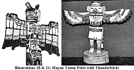
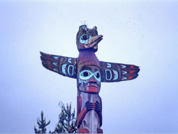
Illustration 22: Alaska Totem Pole with Thunderbird
Von Humboldt, to whose
interesting discussion on this subject reference has been made,
justly enough condemns this confusion between ancient and modern
fable; and shows that the symbolic image of the “Griffins”, as a
poetic fiction and representation in the arts, did precede, among
the Greeks, the time when relations were formed among the colonists
of Pontus and the Arimaspi. The “Griffin” was known to the
Samians,
who figured it upon the vase which commemorated the good fortune of
their first expedition to Tartessus, according to Herodotus. This
mysterious symbol of an animal acting as guardian over gold, seems
to have been the growth of India and of Persia; and the commerce of
Miletus contributed to spread it in Greece along with the
tapestries
of Babylon.
[COMMENT: See Illustration 10
below. The great Pythagoras, who
influenced such historic notables as Apollonius of Tyana, left
behind a drawing of our Solar System, depicting our Earth in
companionship with a “Counter Earth”, as he referred to it.
Pythagoras was born on the Island of Samos, Greece, and moved to
Crotona, Italy, where he inaugurated his famous school, around the
time of the Founding of Rome by Romulus and Remus in 756 BCE. A
Samian riddle regarding Planet X Nibiru’s arrival still survives:
“My cloak I shed in the light of my reflection. My grand entrance I
make after the serpent appears. Then they will know me.” And
Quetzalcoatl, the Mayan Flying Serpent, also vowed to return and
rule for a thousand years. RS]
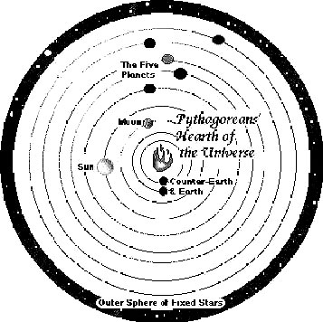
Illustration 10: Pythagorean Counter-Earth
The region of auriferous sand, of which the
Daradas (Dardars, or
Derders,
mentioned in The Mahabharata, and in the fragments of
Megasthenes)
gave
intelligence to travellers, and with which the often-repeated fable
of the ants became connected, owing to the accidental double meaning of a name, belongs
to a more Southern Latitude, 35° or 37°.
From A Dictionary of Greek and Roman Geography,
Volume 2, Page 710,
by Professor William Smith & Others,
London, 1873.
RHIPAEI MONTES, a
name applied by Grecian fancy to a mountain chain whose peaks rose
to the North of the known world. It is probably connected with the
word “ripai”, or the chill rushing blasts of “Boreas”, the mountain
wind or “tramontana” of the Greek Archipelago, which was conceived
to issue from the caverns of this mountain range. Hence arose the
notion of the happiness of those living beyond these mountains—the
only place exempt from the northern blasts. In fact they appear in
the form of “Ripai”, in Alcman, a lyric poet of the 7th century
B.C., who is the first to mention them. The contemporary writers Damastes of Sigeum and
Hellanicus of Lesbos agree in their
statements in placing beyond the fabled tribes of the North the
Rhipaean Mountains from which the north wind blows, and on the other
side of these, on the seacoast, the Hyperboreans.
[COMMENT:
Alcman
wrote in the 7th century BCE, the 600s. Hyperborea, The Night Sun,
made its final loop and departure in 687 BCE, when Assyrian King
Sennacherib’s Army was destroyed by “cosmic forces” at Pelusium,
Sinai.
Only those people living before 687 would have seen this
Planet X Nibiru with their own eyes. It is unclear here whether
Alcman was referring to the true inhabitants of the Rhipaean
Mountains or just to some vague “legend” about them. Without any
newspapers, magazines, videos, movies, photographs and so forth to
remind them of the existence of “Hyperborea”, it would have been
quite easy for ancient people to forget about it, once it had
disappeared from view. RS]
The legends connected with this imagined
range of mountains lingered for a long period in Grecian literature,
as may be seen from the statements of Hecataeus of Abdera and
Aristotle.
Herodotus knows nothing of the
Rhipaean Mountains or the
Alps, though the positive geography of the North begins with him. It
would be an idle inquiry to identify the Rhipaean range with any
actual chain. As the knowledge of the Greeks advanced, the
geographical “mythus” was moved further and further to the North
till it reached the 48th degree of latitude North of the Maeotic
Lake and the Caspian, between the Don, the Volga, and the Jaik,
where Europe and Asia melt as it were into each other in wide plains
or steppes. These “mountains of the winds” followed in the train of
the meteorological “mythus” of the Hyperboreans which wandered with
Heracles far to the West. Geographical discovery embodied the
picture which the imagination had formed.
Poseidonius seems to have considered this range to be
the Alps. The
Roman poets,
borrowing from the Greeks, made the Rhipaean chain the extreme limit
to the North; and Lucan places the sources of the Tanais in this
chain. In the earlier writers the form is Ripaei, but with Pliny and
those who followed him the P becomes aspirated. In the geography of
Ptolemy and Marcian the Rhipaean chain appears to be that gently
rising ground which divides the rivers which flow into the Baltic
from those which run to the Euxine.
[COMMENT: Look at it this way.
In ancient times if you were living in, for example, south-central
Colorado or Russia, and if you looked to the north, you would see
the Rocky Mountains in Colorado and the Urals in Russia. “Beyond the
North” you would see “Hyperborea” tethered atop Yggdrasill,
The
Cosmic Tree. Naturally, you would associate this “Mount Olympus” or
“Mount Zion” or “Mount Meru” with the “Rhipaean Mountains”, where
the North Wind rises, which you would actually be looking at. Then
as the 600s BCE came and went, and those like Pythagoras and
Alcman
died, only distant legends would have remained about this magical,
northernmost “Heaven Of The Gods”. It is said that Alexander The
Great searched and searched across Greece for “Mount Olympus” but
never found it. Of course, he didn’t find it. It wasn’t there
anymore. RS]
From A Dictionary of Greek and Roman Geography,
Volume 2, Pages
68-69,
by Professor William Smith & Others,
London, 1873.
ISSEDONES:
In the Roman writers the usual form is “Essedones”, a people living
to the East of the Argippaei, and the most remote of the tribes of
Central Asia with whom the Hellenic colonies on the Euxine had any
communication. The name is found as early as the Spartan Alcman,
B.C. 671-631, who calls them “Assedones”, and Hecataeus. A great
movement among the nomad tribes of the North had taken place in very
remote times, following a direction from Northeast to Southwest; the
Armaspi had driven out the Issedones from the steppes over which
they wandered, and they in turn drove out the Scythians, and the
Scythians the Cimmerians.
[COMMENT: Note the date above, 671 BCE. That was only 16 years after
687; but perhaps more importantly, it was only 8 years after the Era
of Esarhaddon began at Babylon, which coincided with the date of 679
for the commencement of the Mayan Calendar. For additional details,
I refer the reader to the essay by John Major Jenkins, which can be
found
HERE. This is the second link that I have found
between the end of an era in the Middle East and the origin of an
era in the Americas, civilizations who supposedly knew absolutely
nothing about one another at the time. RS]
Traces of these migrations were indicated in the poem of
Aristeas of
Proconnesus, a semi-mythical personage, whose pilgrimage to the land
of the Issedones was strangely disfigured after his death by the
fables of the Milesian colonists. The Issedones, according to
Herodotus, have a custom, when any one loses his father, for the
kinsfolk to kill a certain number of sheep, whose flesh they hash up
together with that of the dead man, and make merry over it. This
done, they peel and clean out his skull, which after it has been
gilded becomes a kind of idol to which yearly sacrifices are
offered. In all other respects they are a righteous people,
submitting to the rule of women equally with that of men; in other
words, a civilized people.
Heeren, upon
Dr. Leyden’s authority, illustrates this way of
carrying out the duties of filial piety by the practice of the
Battas of Sumatra. It may be remarked that a similar story is told
of the Indian Padaei. Pomponius Mela simply copies the statement of
Herodotus, though he alters it so far as to assert that
the Issedones used the skull as a drinking cup. The name occurs more
than once in Pliny; and Ptolemy, who has a town Issedon in
Serica,
mentions in another place the Scythian Issedon. Alexander Von
Humboldt has shown that, if the relief of the countries between the
Don and the Irtysh be compared with the itinerary traced by
Herodotus from the Thyssagetae to the Issedones, it will be seen
that the Father of History was acquainted with the existence of vast
plains separating the Ural and Altai, chains which modern
geographers have been in the habit of uniting by an imaginary range
passing through the steppe of the Kirghiz.
[COMMENT: A lot of what
Alexander Von Humboldt proposed in his fivevolume series Cosmos, for which I have the greatest respect (and
even a 150-year-old first edition from my Great-Uncle Whit, to whom
this book is dedicated), has been updated with more modern
discoveries. However, he was one of the most prolific astronomical
researchers of the 19th century. It is interesting to note his
mention of the Irtysh River region, where the legend of “the golden
pole with the golden cage on top” originated. RS]
This route
recognizes the passage of the Ural from West to East, and
indicates another chain more to the East and more elevated—that of
the Altai. These claims, it is true, are not designated by any
special names, but Herodotus was not acquainted even in Europe with
the names of the Alps and Rhipaean Mountains; and a comparison of
the order in which the peoples are arranged, as well as the relief
and description of the country, shows that much definite information
had been already attained.
Advancing from the
Palus Maeotis, which was supposed to be of far
larger
dimensions than it really is, in a central direction towards the
Northeast, the first
people found occupying the plains are the “Black-Clothed”
Melanchlaeni, then the
Budini, Thyssagetae, the Iurcae (who have been falsely identified
with the Turks),
and finally, towards the East, a colony of Scythians, who had
separated themselves from the “Royal Scythians” (perhaps to barter
gold and skins). Here the plains end, and the ground becomes broken,
rising into mountains, at the foot of which are the Argippaei, who
have been identified from their long chins and flat noses with the
Kalmucks or Mongolians by Niebuhr, Böckh, and others, to whom
reference is made by Mr. Grote.
This identification has been
disputed by Humboldt, who refers these tribes to the Finnish stock,
assuming as a certain fact, on evidence which it is difficult to
make out, that the Mongolians who lived around Lake Baikal did not
move into Central Asia till the thirteenth century. Where the data
are so few, for the language (the principle upon which the families
of the human race are marked off) may be said to be unknown,
ethnographic analogies become very hazardous, and the more so in the
case of nomad tribes, the same under such wide differences of time
and climate. But if there be considerable difficulty in making out
the analogy of race, the local bearings of these tribes may be laid
down with tolerable certainty.
The country up to
the Argippaei was well known to the traders; a
barrier of impassable mountains blocked up the way beyond. The
position of the Issedones, according to the indications of the
route, must be assigned to the East of Ichim in the steppe of the
central horde of the Kirghiz, and that of the Arimaspi on the North
declivity of the Altai.
The communication between the two peoples for the purpose of
carrying on the gold trade was probably made through the plains at
the Northwest extremity of the Altai, where the range juts out in
the form of a huge promontory.
Go Back
|