|

HAARP Facility in Peru Could Have Caused Earthquakes
June 05, 2008
from
Current Website
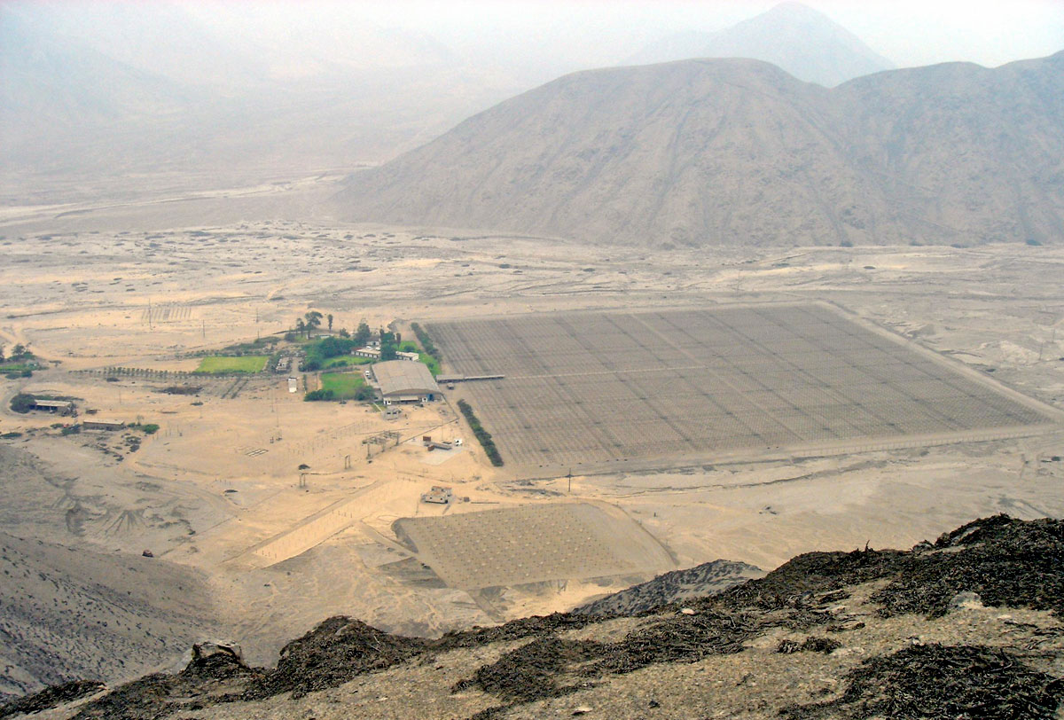
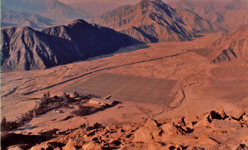
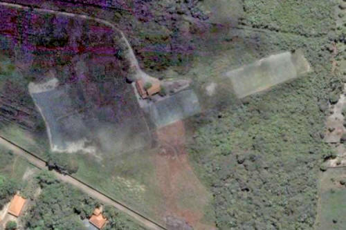
Jicamarca (below image), Peru is home to one of the many worldwide locations of H.A.A.R.P.

HAARP is a
U.S. Military Geophysical weapon (under the guise of an
"environmental research" tool). A magnitude
8.0 Earthquake struck
central Peru, August 15, 2007.
Jicamarca Radio Observatory - Scatter Radar
by
Jly1974
February 5, 2009
from
YouTube Website
Scientists are well aware that HAARP can cause earthquakes and many
other "natural" disasters.
"Environmental warfare is defined as the intentional modification or
manipulation of the natural ecology, such as climate and weather,
earth systems such as the ionosphere, magnetosphere, tectonic plate
system, and/or the triggering of seismic events (earthquakes) to
cause intentional physical, economic, and psycho-social, and
physical destruction to an intended target geophysical or population
location, as part of strategic or tactical war."
http://www.mail-archive.com/balkannews@yahoogroups.com/msg00993.html
"Ionospheric research facilities
have been in continuous use since the early 50's to investigate
fundamental physical principles which govern the earth's
ionosphere, so that present and future transmission technologies
may take into account the complexities of the ionosphere.
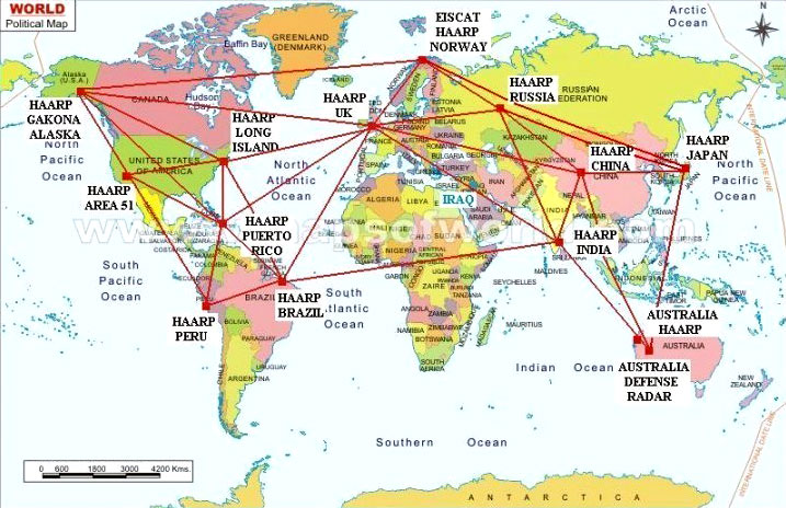
At the present time the US operates
two ionospheric research sites, one in Puerto Rico, near the
Arecibo Observatory, the other (known as HIPAS) in Alaska near
Fairbanks.
Both of these employ active and
passive radio instrumentation similar to that being built at
HAARP. Interest in the ionosphere is not limited to the US: a
five-country consortium runs the European Incoherent Scatter
Radar site (EISCAT), a premier world-class ionospheric research
facility located in northern Norway near Tromsø.
Facilities also are located at,
All of these installations have as
their primary purpose the study of the ionosphere, and most
employ the capability of stimulating to a varying degree small,
localized regions of the ionosphere to discover in a controlled
manner what nature produces at random.
HAARP also will have such a
capability, but what sets HAARP apart from existing facilities
is the unusual combination of a research tool which provides
electronic beam steering, wide frequency coverage and high
effective radiated power collocated with a diverse suite of
scientific observational instruments."
http://www.cyberspaceorbit.com/phikent/haarp/WEATHER.html
A weapon of the US military which consists of weather modification,
mind control, and missile defense, all made possible through the
High Frequency Active Auroral Research Program (HAARP).
HAARP is capable of creating weather
like hurricanes and tornadoes and tsunamis and earthquakes. It is
also capable of altering people's moods.
Some people believe that HAARP technology is being tested on a daily basis in our own
communities though the use of existing
cell phone and radio towers.
It seems like every year they are adding more parts to these towers.
The new towers are being commonly
nicknamed "Death Towers" by diehard conspiracy theorists. It has
been hypothesized by these theorists that Chemtrails & HAARP are
working together and are directly related.
http://replay.waybackmachine.org/20080929012352/http://www.gather.com/viewArticle.jsp?articleId=281474977354201
Jicarmaca - Peru
January 25, 2010
from
ChemtrailDyndns Website
Introduction
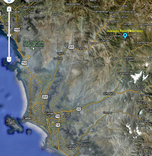
The Jicamarca Radio Observatory is the
equatorial anchor of the Western Hemisphere chain of incoherent
scatter radar (ISR) observatories extending from Lima, Perú, to
Søndre Strømfjord, Greenland.
It is part of the Geophysical
Institute of Peru (Instituto Geofísico del Perú, or
IGP) and
receives the majority of its financial support from the National
Science Foundation of the U.S. through a Cooperative Agreement with
Cornell University.
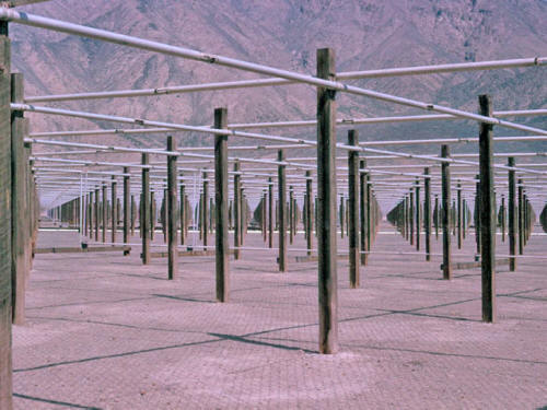
The Observatory is the premier scientific facility in the world for
studying the equatorial ionosphere. It has a 2-MW transmitter and a
main antenna with 18,432 dipoles covering an area of nearly 85,000
square meters.
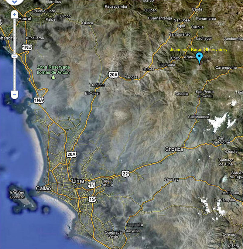
Location
The Observatory is about a half-hour drive inland (east) from Lima,
Peru at a geographic latitude of 11.95° South and a longitude of
76.87° West. The altitude of the Observatory is about 500 m ASL.
It
is about 10 km from the Carretera Central, the main highway east in
Peru.
The magnetic dip angle is about 1°, and
varies slightly with altitude and year. The radar can be pointed
perpendicular to B throughout the ionosphere. (For critical
applications, the dip angle can be determined extremely accurately
with the radar.)
History
The Jicamarca Radio Observatory was built in 1960-61 by the Central
Radio Propagation Laboratory (CRPL) of the
National Bureau of
Standards (NBS).
This lab later became part of the Environmental
Science Service Administration (ESSA) and then the
National Oceanic
and Atmospheric Administration (NOAA). The first incoherent scatter
measurements at Jicamarca were made in late 1961. In 1969 ESSA
turned the Observatory over to the Instituto Geofísico del Perú (IGP),
which had been cooperating with CRPL since at least the IGY in
1957-58, and probably before, and had been intimately involved with
all aspects of the construction and operation of Jicamarca.
ESSA and
then NOAA continued to provide some support for the operations for
several years after 1969, but then phased out their financial
involvement.
The National Science Foundation then began partially
supporting the operation of Jicamarca, first through NOAA, and since
1979 through Cornell University via a Cooperative Agreement. Closely
coupled to the Observatory operations is a private, nonprofit
Peruvian corporation called Ciencia Internacional (CI).
This
corporation hires most of the Observatory staff members and provides
their services to the IGP to run the Observatory.
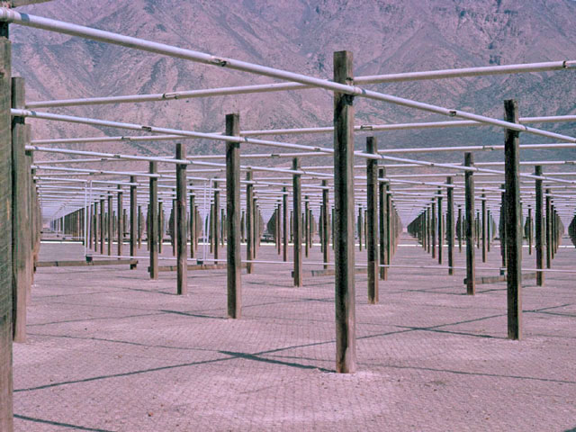
Radar Facilities
The 49.92 MHz incoherent scatter radar is the principal facility of
the Observatory.
The radar antenna consists of a large square array
of 18,432 half-wave dipoles arranged into 64 separate modules of 12
x 12 crossed half-wave dipoles. Each linear polarization of each
module can be separately phased (by hand, changing cable lengths),
and the modules can be fed separately or connected in almost any
desired fashion. There is great flexibility, but changes cannot be
made rapidly.
The individual modules have a beam width of about 7°,
and the array can be steered within this region by proper phasing.
The one way half power beam width of the full array is about 1.1°;
the two way (radar) half power beam width is about 0.8°.
The
frequency bandwidth is about 1 MHz.
The isolation between the linear
polarizations is very good, at least 50 dB, which is important for
certain measurements.
Since the array is on the ground and the
Observatory is the only sign of man in a desert region completely
surrounded by mountains, there is no RF interference.
The original transmitter consisted of four completely independent
modules which could be operated together or separately. Two of those
modules have been converted to a new design using modern tubes and
each of these new modules can deliver a peak power of ~1.5 MW, with
a maximum duty cycle of 6%, and
pulses as short as 0.8-1.0µs.
Pulses as long as 2 ms show little power droop; considerably longer
pulses are probably possible. The other two modules are currently
unavailable until their conversion is complete. The third is
actually more than 95% complete; the fourth is well advanced. The
drivers of the main transmitter can also be used as transmitters for
applications requiring only 50-100 KW of peak power.
An additional antenna module with 12 x 12 crossed dipoles was built
in 1996. It is located 204 m to the west of the west corner of the
main antenna and increases the lengths of the available
interferometer base line to 564 m.
There are 3 additional 50 MHz "mattress" array antennas steerable to
+/-70° zenith angles in the E-W direction only. Each consists of 4 x
2 half-wave dipoles mounted a quarter wavelength above a ground
screen. Two of these arrays can handle high powers.
There is also a
single fat dipole mounted a quarter wavelength above ground that can
handle at least a megawatt. There is a lot of land around the
Observatory for additional antennas for special experiments. Arrays
of a kilometer or more in length could be set up (in certain
directions).
There are four phase-coherent (common oscillators) receivers for the
radars. These mix the signal to baseband (with two quadrature
outputs each), with maximum output bandwidths of about 1 MHz.
Filters are available with nominal impulse response time constants
ranging from 1 to 500µs.
As many as eight data channels (four
complex pairs) can be sampled simultaneously with 125 m (0.83µs)
resolution and fed to a large FIFO buffer/coherent integrator, and
from there to one of the computers. We are in the process of
designing new receivers; we plan to have at least eight, with more
precise digital filtering at the output.
The computing hardware at JRO is constantly evolving. For many years
the main data-taking computer has been a Harris H800 with various
tape drives, including two Exabyte 2.2 GByte 8 mm cassette tape
drives (maximum writing speed of 256 KBytes/s). But now there is
also a Harris Nighthawk computer (UNIX operating system) with an
80-MFLOPS array processor and various workstations and PCs, all
networked together.
Data acquisition can be hosted by any one of a
number of these machines with real-time processing and display
capabilities.
The JULIA radar shares the main antenna of the Jicamarca Radio
Observatory.
JULIA (which stands for Jicamarca Unattended Long-term
investigations of the Ionosphere and Atmosphere) has an independent
PC-based data acquisition system and makes use of some of the
exciter stages of the Jicamarca radar along with the main antenna
array.
Since this system does not use the main high-power
transmitters (which are expensive and labor intensive to operate and
maintain), it can run unsupervised for long periods of time. With a
pair of 30-kW peak power pulsed transmitters driving a 290 m by 290
m modular antenna array, JULIA is a formidable MST/coherent scatter
radar.
It is uniquely suited for studying the day-to-day and
long-term variability of equatorial plasma irregularities and
neutral atmospheric waves, which until now have only been
investigated episodicly or in campaign mode.
Other Instruments at the Observatory
-
A Digisonde Portable Sounder (DPS) from the University of Lowell is
located at the Observatory and operates nearly continuously. The DPS
is battery operated and therefore is unaffected by power outages. It
has four antennas feeding four receivers and can measure drifts as
well as density profiles.
-
A modern magnetometer has been donated to the Observatory by the
University of Tromso.
Additional Observatories and Facilities
in Peru
-
A major airglow facility is located at Arequipa in southern Peru.
Instruments include a
Fabry Perot interferometer and an all-sky
imager. These facilities are operated by Dr.
John Meriwether of
Clemson University and ???
-
An MST radar has been built at the University of Piura in northern
Peru using components from the former NOAA Poker Flat MST radar.
Piura is approximately 800 km north of Jicamarca at about 4 deg S
geographic latitude and is the eastern anchor of the NOAA pacific
equatorial chain of MST radars. The University of Piura has been
extremely helpful and competent in this project.
There is a good
opportunity for collaborative MST observations with Jicamarca,
comparing equatorial (geographic) and off-equatorial behavior, for
example. Conversely, Piura is at the northern edge of the magnetic
equatorial region, and so there may be opportunities for interesting
E- and F-region plasma instability comparisons.
And lastly, the
skies at Piura are almost always extremely clear; it could be an
excellent airglow observing site. For further information about the
Piura facilities, contact...
-
Satellite scintillation measurements are made at Ancon on a campaign
basis by Santi and Sunandu Basu and their colleagues. Ancon is about
50 km northwest of Jicamarca on the coast.
-
A magnetometer is also located at Ancon.
-
There is a rocket range 50 km or so south of Lima at Punta Lobos
that has been used twice by NASA (1975 for project Antarqui, and
1983 for project CONDOR) and once by Germany (1979).
Measurement Capabilities
-
Of all the ISR observatories, Jicamarca provides by far the most
accurate drift velocity and electric field data. This is because of
the unique equatorial geometry.
Pointing perpendicular to the
magnetic field makes it possible to measure line-of-sight
drift velocities to accuracies of the order of 0.5 m/s
without difficulty. Vertical F-region plasma drifts of this
accuracy translate to zonal electric field accuracies of
about 12 mV/m.
Determining zonal drifts
involves subtracting two slightly off vertical line-of-sight
measurements, and so the uncertainties are about ten times larger,
but the mean drifts are also larger.
By studying the variation of
drift velocity with altitude, up to altitudes of 800-1000 km or
perhaps even higher, it is possible to study the electrodynamics of
the entire low-latitude ionosphere, up to the anomaly latitudes,
because of the way the electric field maps along the geomagnetic
field lines.
-
Jicamarca also has a unique capability to probe the ionosphere to
very high altitudes. Because of the long radar wavelength, the
incoherent scatter is not affected by Debye length problems at low
electron densities, and usable signals can be obtained from
altitudes of 5000 km and higher, giving densities and perhaps
temperatures (but not drifts since the beam cannot be simultaneously
pointed perpendicular to B).
-
Absolute F-region measurements of electron density are performed
using Faraday rotation. Electron and ion temperatures and ion
compositions are obtained with a double pulse technique that
generates the signal auto-correlation function. Pulses are
transmitted on orthogonal polarizations to reduce clutter.
-
The Jicamarca radar is the most sensitive MST radar in the world; in
fact, it is the only true MST radar, capable of probing even the
"gap" region near 45-50 km, partly because of its long wavelength
(so there are fewer problems with the turbulent viscous cutoff) and
partly because it has the largest power-aperture product of any VHF
radar.
Scientific Programs
Jicamarca participates in all
the IS World Day runs, thereby supporting assorted CEDAR initiatives
such as GISMOS, LTCS, SUNDIAL, CADRE, and MISETA. Some of these are
described in more detail below:
-
The
CADRE (Coupling And Dynamics of Regions Equatorial) campaign is
examining the dynamical coupling processes operating within, and
accounting for the large scale structure and variability of, the
equatorial middle atmosphere. CADRE employs a wide range of radar, lidar, optical, rocket, and satellite instrumentation at various
locations.
The role of Jicamarca in CADRE is to study the effect of
small scale gravity waves, specifically the vertical fluxes of
momentum, their interactions with tidal and other equatorial motions
at larger scales, and their forcing of the QBO and SAO at
stratospheric and mesospheric heights. CADRE campaigns have been
carried out in January 1993, March 1994, and August 1994.
-
MISETA (Multi-Instrumented Studies of Equatorial Thermospheric
Aeronomy) is investigating F-region winds and zonal plasma drifts
using Fabry-Perot interferometry and all-sky imaging at 630 and 774
nm from Arequipa, scintillation drift measurements at Ancon, and
digisonde and ISR drift measurements at Jicamarca.
One goal is to understand why
the irregularities (that cause the scintillations) develop
on some nights, but not others. MISETA campaigns have been carried out in the Fall of
1994 and 1996.
-
Jicamarca has had a long standing (since the early 1960s) program of
radar studies of plasma instabilities in the equatorial E and F
regions. The E-region instabilities are driven by the equatorial electrojet current and are quite similar to instabilities found in
the auroral E region, but the equatorial geometry and the power and
versatility of the Jicamarca radar make the essential physics of
these phenomena much easier to study at the equator.
The sometimes
spectacular F-region instabilities are unique to equatorial
latitudes. Both are nice examples of fully developed (nearly) 2-D
plasma turbulence, and they provide a unique laboratory for studies
of some fundamental nonlinear plasma processes.
The E-region
instabilities may affect the layer conductivity and hence the global
Sq current system, and both instabilities can affect communications
and navigational systems such as GPS.
-
The radar can accurately determine where the radar beam is
perpendicular to B via an interferometer method.
This capability has
allowed the tracking of small changes in the Earth's magnetic field
during the lifetime of the Observatory.
Facilities For Visiting Scientists
Many visitors to JRO stay at the El Pueblo resort hotel (two big
pools, two clay tennis courts, golf course), which is very nice and
relatively inexpensive by U.S. standards.
It is outside of Lima,
only a short 10-km drive from the Observatory. There are also many
nice hotels in Lima in assorted price ranges. The food at the Pueblo
is good, but in Lima it is superb at most restaurants. On the other
hand, staying in Lima means fighting the rush hour traffic every
day.
The terrorist threat (the Sendero Luminoso) in Peru is
essentially gone now. Lima is probably a lot safer than Miami or New
York, or assorted other U.S. cities.
Scheduling and Costs
Scheduling experiments at
Jicamarca is still handled in an informal way. Anyone wishing to
observe at Jicamarca should get in touch with Donald Farley at
Cornell and/or Ronald Woodman at JRO. Remember to avoid the IS World
Day periods (see the International Geophysical Calendar).
Periods
around July 28 (Peruvian Independence Day, a big holiday period),
Easter, and Christmas are also times when key personnel may be
absent. The staff normally works four 10-hour days per week
(Monday-Thursday), partly so that they can hold other jobs. If you
plan to run at night or during Friday-Sunday, you should be prepared
to pay overtime charges to the staff members involved.
These charges
might add up to $30-50/hour, depending upon the number of people
involved. The staff members are generally very happy to work
overtime, because the payments represent a substantial boost to
their income.
If your research is sponsored by the National Science Foundation,
there is no charge for observing time, other than for possible
overtime, as just discussed. For those with other funding, there is
a charge of approximately $8000 per day of observing, for isolated
experiments.
For longer, on-going programs not supported by the NSF,
special arrangements for Observatory support should be made. (http://jicamarca.ece.cornell.edu/)
HAARP Like Facility -
São Luiz Space Observatory
from
TheLivingMoon Website
Coherent Back-Scatter Radar 50 MHz (RESCO)
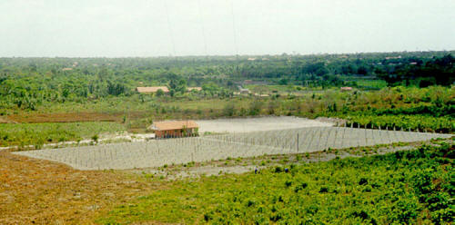
Cruzeiro Santa Bárbara, Sao Luis-MA, Brasil
-2° 35' 40.47", -44° 12' 35.90"
Image courtesy São Luiz Space Observatory
The Coherent Back-Scatter Radar of 50 MHz (RESCO) was installed at
the Space Observatory of São Luís/INPE, whose operation begun in
August of 1998, is capable to accomplish measures of dynamics of the
plasma of the electrojet and of bubbles equatorial ionospheric.
This radar was projected to map the
turbulence and the electromagnetic drift of the irregularities of
short length scale (3 meters) in a height range that extends from
~90 km to ~1000 km of the equatorial ionosphere.
Such plasma
irregularities have big influence in the propagation
trans-ionosphere of waves in a great frequency range, VHF to UHF,
and, therefore, it influence all of the activities of space
communications of the Brazilian tropical area.
The formation, the development and the
space distribution of these irregularities are highly sensitive to
the space climatic change (in other words, "Space Weather") besides
the convection processes and of the storms of the troposphere.
This radar resulted of the development and construction begun in
INPE there are several years. It transmits signs pulse of high
potency through an network antenna with 768 dipoles which allow to
concentrate all the energy transmitted in only narrow beam
radiation. The same antenna also captures the echo signs spread by
the irregularities ionosphere.
The transmitted maximum power (120 kW)
it is reached through the use of a modular system of 8 transmitters
in phase to maximize the transmitted energy. The operational control
of the radar is made by a computer, which also accomplishes the
acquisition, the treatment and processing 'on line' of the received
data of the ionosphere.
The data recorded are available also for
the processing and analyze subsequent. This radar was already
operated in several campaigns since 1998 and now it is collecting in
a routine way data of the dynamics of the equatorial electrojet.
This radar, with the FCI radar of 30 MHz together offers great
opportunities to the researchers of studying the peculiar phenomenon
of the equatorial area.
These, beside the radars of,
-
Peru (Jicamarca)
-
India (Thumba)
-
Indonesia,
...are some of the few
radars of this type that exist in the world around of the magnetic
equator.
Due to the peculiar configuration of the
geomagnetic field, the Brazilian equatorial area have
characteristics very different from the other areas. It was for this
reason that NASA of the USA, in collaboration of INPE, accomplished
in Alcântara in 1994 the campaign GUARÁ when 26 rockets were thrown
(in the period of September-October) to study the equatorial
electrojet and the bubbles ionosphere.
In this campaign were used another radar
similar to the radar RESCO (which was brought of the USA),
Digissonde (which provided the diagnoses of the ionosphere) and of
the magnetometers operated by INPE in the Space Observatory of São
Luís.
The radar RESCO, that is now in a phase of technological
improvement, offers great potential to promote researches of the
environment of the Brazilian equatorial area.
Information
|