|
Chapter 49 -
The Power of the Thing
On a scale of 1:43,200 the Great Pyramid serves as a model, and
map-projection, of the northern hemisphere of the earth. What
absolutely excludes the possibility that this could be a coincidence
is the fact that the scale involved is keyed in numerically to the
rate of precession of the equinoxes—one of earth’s most
characteristic planetary mechanisms.
It is therefore clear that we
are confronted here by the manifestation of a deliberate planning
decision: one intended to be recognizable as such by any culture
which had acquired,
(a) an accurate knowledge of the dimensions of
the earth
(b) an accurate knowledge of the rate of precessional
motion
Thanks to the work of Robert Bauval, we can now be certain that
another deliberate planning decision was implemented in the Great
Pyramid (which—it is increasingly apparent—must be understood as a
device designed to fulfill many different functions). In this case
the plan was a truly ambitious one involving the Second and Third
Pyramids as well, but it bears the fingerprints of the same ancient
architects and builders who conceived of the Great Pyramid as a
scale model of the earth.
Their hallmark seems to have been
precession—perhaps because they liked its mathematical regularity
and predictability—and they used precession to devise a plan which
could be understood properly only by a scientifically advanced
culture.
Ours is such a culture, and Robert Bauval is the first to have
worked out the basic parameters of the plan—a discovery for which he
has received public acclaim and will in due course, get the
scientific recognition he deserves.1
Belgian by nationality, born
and brought up in Alexandria, he is tall, lean, clean-shaven,
forty-something, and going a little thin on top. His most notable
feature is a stubborn lower jaw which characterizes his tenacious,
inquiring personality; he speaks with a hybrid
French-Egyptian-English accent and is decidedly oriental in manner.
He has a first-class mind and is always restlessly accumulating and
analyzing new data relevant to his interests, finding new ways to
look at old problems. In the process, entirely by accident, he has
succeeded in transforming himself into a kind of magician of
esoteric knowledge.
1
Robert Bauval’s The Orion Mystery (Heinemann, London; Crown, New
York; Doubleday, Canada; List, Germany; Planeta, Spain; Pygmalion,
France, etc.) was an international bestseller when it was published
in 1994. Egyptologists closed ranks against its implications, which
they refused to discuss, but many distinguished astronomers hailed
Bauval’s findings as a breakthrough.
The Orion Mystery
The roots of Bauval’s discoveries at Giza go back to the 1960s when
the Egyptologist and architect Dr. Alexander Badawy and the American
astronomer Virginia Trimble demonstrated that the southern shaft of
the King’s Chamber in the Great Pyramid was targeted like a
gun-barrel on the Belt of Orion during the Pyramid Age—around 2600
to 2400 BC.2
Bauval decided to test the southern shaft of the Queen’s Chamber,
which Badawy and Trimble had not investigated, and established that
it had been sighted on the star Sirius during the Pyramid Age. The
evidence that proved this was provided by the German engineer Rudolf Gantenbrink as a result of measurements taken by his
robot Upuaut in
March 1993.
This was the robot that had made the startling discovery
of a closed portcullis door blocking the shaft at a distance of
about 200 feet from the Queen’s Chamber. Equipped with a high-tech
on-board clinometer, the little machine had also provided the
first-ever completely accurate reading of the shaft’s angle of
inclination: 39° 30’.3
As Bauval explains:
I did the calculations and these established
that the shaft had been targeted on the meridian transit of Sirius
around the epoch 2400 BC. There couldn’t be any doubt about it at
all. I also recalculated the Orion’s Belt alignment worked out by Badawy and Trimble with new data that Gantenbrink gave me on the
inclination of the southern shaft of the King’s Chamber.
He’d
measured that at 45 degrees exactly, whereas Badawy and Trimble had
worked with Flinders Petrie’s slightly less accurate measurement of
44° 30’. The new data enabled me to refine Badawy’s and Trimble’s
date for the alignment. What I found was that the shaft had been
precisely targeted on Al Nitak, the lowest of the three belt stars,
which crossed the meridian at altitude 45 degrees around the year
2475 BC.4
Up to this point Bauval’s conclusions had been well within the
chronological bounds set by orthodox Egyptologists, who normally
dated the construction of the Great Pyramid to around 2520 BC.5 If
anything, the alignments the archaeo-astronomer had come up with
suggested that the shafts had been built a little later, rather than
earlier, than conventional wisdom allowed.
2 Virginia Trimble, cited in The Orion Mystery, p. 241.
3 Ibid., p.
172.
4 Personal communications/interviews, 1993-4.
5 Atlas of Ancient Egypt, p. 36.
As the reader is aware, however, Bauval had also made another
discovery of an altogether more unsettling nature. Once again it
involved the stars of Orion’s Belt:
They’re slanted along a diagonal in a south-westerly direction
relative to the axis of the Milky Way and the pyramids are slanted
along a diagonal in a southwesterly direction relative to the axis
of the Nile. If you look carefully on a clear night you’ll also see
that the smallest of the three stars, the one at the top which the
Arabs call Mintaka, is slightly offset to the east of the principal
diagonal formed by the
other two.
This pattern is mimicked on the ground where we see that
the Pyramid of Menkaure is offset by exactly the right amount to the
east of the principal diagonal formed by the Pyramid of Khafre
(which represents the middle star, Al Nilam) and the Great Pyramid,
which represents Al Nitak. It’s really quite obvious that all these
monuments were laid out according to a unified site plan that was
modelled with extraordinary precision on those three stars. ... What
they did at Giza was to build Orion’s Belt on the ground.’6
There was more to come. Using a sophisticated computer programme7
capable of plotting the precessionally induced changes in the
declinations of all the stars visible in the sky over any part of
the world in any epoch, Bauval found that the Pyramids/Orion’s Belt
correlation was general and obvious in all epochs, but specific and
exact in only one:
At 10,450 BC—and at that date only—we find that the pattern of the
pyramids on the ground provides a perfect reflection of the pattern
of the stars in the sky. I mean it’s a perfect match—faultless—and
it cannot be an accident because the entire arrangement correctly
depicts two very unusual celestial events that occurred only at that
time.
First, and purely by chance, the Milky Way, as visible from Giza in 10,450 BC, exactly duplicated the meridional course of the
Nile Valley; secondly, to the west of the Milky Way, the three stars
of Orion’s Belt were at the lowest altitude in their precessional
cycle, with Al Nitak, the star represented by the Great Pyramid,
crossing the meridian at 11° 08’.8
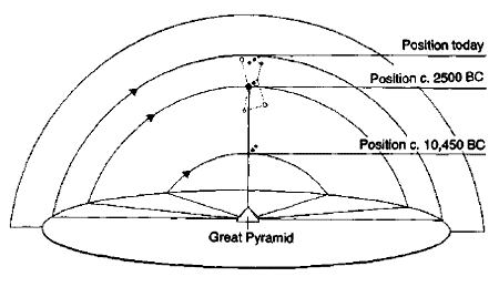
Precession and the stars of Orion’s belt.
6 Personal communications/interviews.
7 Skyglobe 3.6.
8 Personal communications/interviews.
The reader is already familiar with the way the earth’s axial
precession causes sunrise on the vernal equinox to migrate along the
band of the zodiac over a cycle of about 26,000 years. The same
phenomenon also affects the declination of all visible stars,
producing, in the case of the Orion constellation, very gradual but
significant changes in altitude.
Thus
from its highest point at meridian transit (58° 11’ above the
southern horizon as viewed from Giza) it takes Al Nitak about 13,000
years to descend to the low point, last registered in 10,450 BC,
that is immortalized in stone on the Giza plateau—i.e. 11° 08’. As
another 13,000 years pass, the belt stars very slowly rise again
until Al Nitak is back at 58° 11’; then during the next 13,000 years
they gradually fall once more to 11° 08’. This cycle is eternal:
13,000 years up, 13,000 years down, 13,000 years up, 13,000 years
down, for ever. 9
It’s the precise configuration for 10,450 BC that we see on the Giza
plateau—as though a master-architect came here in that epoch and
decided to lay out a huge map on the ground using a mixture of
natural and artificial features. He used the meridional course of
the Nile Valley to depict the Milky Way, as it looked then. He built
the three pyramids to represent the three stars, exactly as they
looked then.
And he put the three pyramids in exactly the same
relationship to the Nile Valley as the three stars then had to the
Milky Way. It was a very clever, very ambitious, very exact way to
mark an epoch—to freeze a particular date into architecture if you
like ...10
9 Skyglobe 3.6
10 Personal communications/interviews.
The First Time
I found the implications of the Orion correlation complicated and
eerie.
On the one hand, the Great Pyramid’s southern shafts ‘precessionally
anchored’ the monument to Al Nitak and Sirius in 2475-2400 BC, dates
which coincided comfortably with the epoch when Egyptologists said
the monument had been built.
On the other hand the disposition of all three of the pyramids in
relation to the Nile Valley eloquently signalled the much earlier
date of 10,450 BC. This coincided with the controversial geological
findings John West and Robert Schoch had made at Giza, which
suggested the presence of a high civilization in Egypt in the
eleventh millennium BC.
Moreover, the disposition of the pyramids
had not been arrived at by any random or accidental process but
seemed to have been deliberately chosen because it marked a precessionally significant event: the lowest point, the beginning,
the First Time in Orion’s 13,000-year ‘up’ cycle.
I knew that Bauval believed this astronomical event to have been
linked symbolically to the mythical First Time of Osiris—the time of
the gods, when civilization had supposedly been brought into the
Nile Valley—and that his reasoning for this derived from the
mythology of Ancient Egypt which directly associated Osiris with the
Orion constellation (and Isis with Sirius).11
11 See Chapters Forty-two to Forty-four.
Had the historical archetypes for Osiris and Isis actually come here
in
the First Time, twelve and a half thousand years ago?12 My research
into Ice Age mythologies had persuaded me that certain ideas and
memories could linger in the human psyche for many millennia,
transmitted from generation to generation by oral tradition. I could
therefore see no prima facie reasons why the Osirian mythology, with
its strange and anomalous characteristics, should not have
originated as far back as 10,450 BC.
12
‘The Egyptians ... believed that they were a divine nation, and that
they were ruled by kings who were themselves gods incarnate; their
earliest kings, they asserted, were actually gods, who did not
disdain to live on earth, and to go about up and down through it,
and to mingle with men.’ The Gods of the Egyptians, volume I, p. 3.
However, it was the civilization of dynastic Egypt that had elevated
Osiris to the status of the high god of resurrection. That
civilization was one that had few known antecedents, and none at all
recognizable in the remote epoch of the eleventh millennium BC.
-
If
the Osirian mythology had been transmitted across 8000 years,
therefore, then what culture had transmitted it?
-
And had this
culture also been responsible for both the astronomical alignments
proven to have been manifested by the pyramids: 10,450 BC and 2450
BC?
These were among the questions I planned to put to Robert Bauval in
the shadow of the pyramids. Santha and I had arranged to meet him at
dawn, at the Mortuary Temple of Khafre, so that the three of us
could watch the sun come up over the Sphinx.

The pyramids and the belt stars of Orion at 10,450 BC, meridian
view.
The platform
Positioned beside the eastern face of the Second Pyramid, the
largely ruined Mortuary Temple was a spooky, grey, cold place to be
at this hour. And as John West had indicated during our conversation
at Luxor, there could be little doubt that it belonged to the same
severe, imposing and unadorned style of architecture as the
better-known Valley Temple. Here, at any rate, were the same
enormous blocks, weighing 200 tons or more each.13
13
The Mortuary Temple was excavated by von Sieglin in 1910 and was
found to consist of blocks of varying sizes weighing ‘between 100
and 300 tons’. Blue Guide: Egypt, p.
431.
And here too was
the same intangible atmosphere of vast antiquity and awakening
intelligence, as though some epiphany might be at hand. Even in its
present, much despoiled state, this anonymous structure, which
Egyptologists had called a Mortuary Temple, was still a place of
power that seemed to draw its energy from an epoch far in the past.
I looked up at the huge mass of the Second Pyramid’s eastern face
just behind us in the pearl-grey dawn light. Again, as John West had
pointed out, there was much to suggest that it might have been built
in two different stages. The lower courses, up to a height of
perhaps thirty feet, consisted largely of cyclopean limestone
megaliths like those in the temples. Above this height, however, the
remainder of the pyramid’s gigantic core had been formed out of much
smaller blocks weighing around two to three tons each (like the
majority of the blocks in the Great Pyramid).
-
Had there been a time when a twelve-acre, thirty-foot-high
megalithic platform had stood here on the ‘hill of Giza’, west of
the Sphinx, surrounded only by nameless square and rectangular
structures such as the Valley and Mortuary Temples?
-
In other words,
was it possible that the Second Pyramid’s lower courses might have
been built first, before the other pyramids—perhaps long before, in
a much earlier age?
The cult
That question was still on my mind when Robert Bauval arrived. After
exchanging a few chilly pleasantries about the weather—a cold desert
wind was blowing across the plateau—I asked him,
‘How do you account
for the 8000-year gap in your correlations?’
‘Gap?’
‘Yes; shafts that seem to have been aligned in 2450 BC and a
site-plan that maps star positions in 10,450 BC.’
‘Actually, I see two explanations that both make some kind of
sense,’ said Bauval, ‘and I think the answer has to be one or the
other of these ... Either the pyramids were designed as a sort of
“star-clock” to mark two particular epochs, 2450 and 10,450 BC, in
which case we actually can’t say when they were built. Or they were
built up over ...’
‘Hang on with that first point,’ I interrupted. ‘How do you mean
“starclock”? How do you mean we can’t say when they were built?’
‘Well, let’s assume for a moment that the pyramid builders knew
precession. Let’s assume they were able to calculate the declination
of particular star-groups backwards and forwards in time, just as we
can today with computers ... Assuming they could do that then, no
matter which epoch they lived in, they’d have been able to make a
model of what the skies over Giza looked like in 10,450 BC or 2450
BC as required, just as we could. In other words, if they’d built
the pyramids in 10,450 BC they would have had no difficulty in
calculating the correct angles of inclination for the southern
shafts so that they would be sighted on Al Nitak and Sirius around
2450 BC.
Likewise, if they’d lived in 2450 BC they’d have had no
difficulty in calculating the correct site-plan to reflect the
position of Orion’s Belt in 10,450 BC. Agreed?’
‘Agreed.’
‘OK. That’s one explanation. But the second explanation, which I
personally favour—and which I think the geological evidence also
supports—is that the whole Giza necropolis was developed and built
up over an enormously long period of time. I think it’s more than
possible that the site was originally planned and laid out at around
10,450 BC, so that its geometry would reflect the skies as they
looked then, but that the work was completed, and the shafts of the
Great Pyramid aligned, around 2450 BC.’
‘So you’re saying that
the ground-plan of the Pyramids could date
back to 10,450 BC?
‘I think it does. And I think that the geometrical centre of that
plan was located more or less where we’re standing now, right in
front of the Second Pyramid ...’
I pointed out the large blocks in the lower courses of the huge
edifice:
‘It even looks like it was built in two stages, by
two
completely different cultures ...’
Bauval shrugged.
‘Let’s speculate ... Maybe it wasn’t two different
cultures, Maybe it was one culture, or cult—the cult of Osiris,
perhaps. Maybe it was a very long-lived, very ancient cult dedicated
to Osiris that was here in 10,450 BC and was still here in 2450 BC.
Maybe what happened was that some of the ways that this cult did
things changed over time. Maybe they used huge blocks in 10,450 BC
and smaller blocks in 2450 BC ... It seems to me there’s a lot here
that supports this notion, a lot that says “very ancient cult”, a
lot of evidence that has just never been investigated ...’
‘For example?’
‘Well, obviously the astronomical alignments of the site. I’ve been
among the first to start looking into those properly. And the
geology: the work that John West and Robert Schoch have been
involved in at the Sphinx. Here are two sciences—both hard,
empirical, evidence-driven sciences—that have never been applied to
these problems before. But now that we have started to apply them,
we’re beginning to get a whole new reading on the antiquity of the
necropolis.
And I honestly think we’ve just scratched the surface
and that much more will emerge from the geology and the astronomy in
the future. In addition, nobody’s yet made a really detailed study
of the Pyramid Texts from anything other than the so-called
“anthropological” perspective, which means a preconceived notion
that the priests of Heliopolis were a bunch of half-civilized
witch-doctors who wanted to live for ever ...
Actually they did want
to live for ever but they certainly weren’t witch-doctors ... They
were highly civilized, highly initiated men and they were, in their
own fashion, scientists, as we can judge from their works. Therefore
I suggest that it’s as scientific or at least quasi-scientific
documents that
the Pyramid Texts need to be read, not as
mumbo-jumbo. I’m already satisfied that they respond to precessional
astronomy. There may be other keys too: mathematics,
geometry—particularly geometry ... Symbolism ...
What’s needed is a
multi-disciplinary approach to understanding the Pyramid Texts ...
and to understanding the pyramids themselves. Astronomers,
mathematicians, geologists, engineers, architects, even philosophers
to deal with the symbolism—everybody who can bring a fresh eye and
fresh skills to bear on these very important problems should be
encouraged to do so.’
‘Why do you feel the problems are so important?’
‘Because they have a colossal bearing on our understanding of the
past of our own species. The very careful, very precise
site-planning and setting-out that appears to have been done here in
10,450 BC could only have been the work of a highly-evolved,
probably technological civilization. ...’
‘Whereas no such civilization is supposed to have existed anywhere
on earth in that epoch ...’
‘Exactly. It was the Stone Age. Human society was supposed to have
been at a very primitive level, with our ancestors wearing skins,
sheltering in caves, following a hunting-gathering way of life and
so on and so forth.
So its rather unsettling to discover that
civilized people seem to have been present in Giza in 10,450 BC, who
understood the obscure science of precession extremely well, who had
the technical capacity to work out that they were witnessing the
lowest point in Orion’s precessional cycle—and thus the beginning of
the constellation’s 13,000 year upwards journey—and who set out to
create a permanent memorial of that moment here on the plateau. By
putting Orion’s Belt on the ground in the way they did they knew
that they were freezing a very specific moment in time.’
A perverse thought occurred to me:
‘How can we be so sure that the
moment that they were freezing was 10,450 BC? After all, Orion’s
Belt takes up that same configuration in the southern sky, west of
the Milky Way at 11-plus degrees above the horizon, once every
26,000 years. So why shouldn’t they have been immortalizing 36,450
BC or even the precessional cycle that began 26,000 years before
that?’
Robert was clearly ready for this question.
‘Some ancient records do
suggest that Egyptian civilization had roots going back almost
40,000 years,’ he mused, ‘like that strange report in Herodotus that
talks about the sun rising where it once set and setting where it
once rose ...’
‘Which is also a precessional metaphor ...’
‘Yes. Precession again. Most peculiar the way it always keeps
cropping up ... At any rate, you’re right, they could have been
marking the beginning of the previous precessional cycle ...’
‘But do you think they were?’
‘No. I think 10,450 BC is the more likely date. It’s more within the
range of what we know about the evolution of homo sapiens. And
although it still leaves a lot of years to account for before the
sudden emergence of dynastic Egypt around 3000 BC, it isn’t too long
a period ...’
‘Too long a period for what?’
‘It’s the answer to your question about the 8000-year gap between
the alignment of the site and the alignment of the shafts. Eight
thousand years is a very long time but it isn’t too long for a
dedicated highly motivated cult to have preserved and nurtured and
faithfully passed on the high-knowledge of the people who invented
this place in 10,450 BC.’14
14
Just as any great Christian cathedral, however modern (for example
the twentieth-century gothic cathedral on Nob Hill in San
Francisco), expresses the thinking, symbolism and iconography of the
Judaeo-Christian ‘cult’ which has roots at least 4000 years old, it
should not be impossible to imagine a cult enduring for 8000 years
in Ancient Egypt and thus linking the epoch of 10450 BC to 2,450 BC.
The completion of the pyramids at that time, like the completion of
a cathedral today, would therefore have resulted in structures that
expressed extremely old ideas.
Plentiful evidence exists within
Ancient Egyptian tradition which seems to attest to the existence
and preservation of such ancient ideas. For example, ‘King Nefer-hetep [XIIIth Dynasty] was a loyal worshipper of Osiris and
hearing that his Temple [at Abydos] was in ruins, and that a new
statue of the god was required, he went to the temple of Ra-Atum at
Heliopolis, and consulted the books in the library there, so that he
might learn how to make a statue of Osiris which should be like that
which had existed in the beginning of the world ...’ (Osiris and the
Egyptian Resurrection, volume II, p. 14).
Also Sacred Science; pp.
103-4, explains that the construction of temples in the Ptolemaic
and late periods of Egyptian history continued to obey very ancient
specifications: ‘All the plans always refer to a divine book; thus
the temple of Edfu was rebuilt under the Ptolemies according to the
book of foundation composed by Imhotep, a book descended from heaven
to the north of Memphis. The temple of Dendera followed a plan
recorded in ancient writings dating from the Companions of Horus.’
The machine
How high was the knowledge of those prehistoric inventors?
‘They knew their epochs,’ said Bauval, ‘and the clock that they used
was the natural clock of the stars. Their working language was
precessional astronomy and these monuments express that language in
a very clear, unambiguous, scientific manner. They were also highly
skilled surveyors—I mean the people who originally prepared the site
and laid
out the orientations for the pyramids—because they worked to an
exacting geometry and because they knew how to align the
base-platforms, or whatever it was they built, perfectly to the
cardinal points.’
‘Do you think they also knew that they were marking out the site of
the Great Pyramid on latitude 30° North?’
Bauval laughed:
I’m certain they knew. I think they knew everything
about the shape of the earth. They knew their astronomy. They had a
good understanding of the solar system and of celestial mechanics.
They were also incredibly accurate and incredibly precise in
everything they did. So, all in all, I don’t think anything really
happened here by chance— at least not between 10,450 and 2450 BC.
I
get the feeling that everything was planned, intended, carefully
worked out ... Indeed I get the feeling that they were fulfilling a
long-term objective—some kind of purpose, if you like, and that they
brought this to fruition in the third millennium BC ...
‘In the form of the fully built pyramids which they then
precessionally anchored to Al Nitak and to Sirius at the time of
completion?’
‘Yes. And also, I think, in the form of the Pyramid Texts. My guess
is that the Pyramid Texts are part of the puzzle.’
‘The software to the Pyramids’ hardware?’
‘Quite possibly. Why not? At any rate it’s certain that there’s a
connection. I think what it means is that if we’re going to decode
the pyramids properly then we’re going to have to use the Texts ...’
‘What’s your guess?’ I asked Bauval. ‘What do you think the purpose
of the pyramid builders really might have been?’
‘They didn’t do it because they wanted an
eternal tomb,’ he replied
firmly. ‘In my view, they had no doubts at all that they would
eternally live. They did it—whoever did it—they have transmitted the
power of their ideas through something that is to all intents and
purposes eternal. They succeeded in creating a force that is
functional in itself, provided you understand it, and that force is
the questions it challenges you to ask. My guess is that they knew
the human mind to perfection. They knew the game of ritual ...
Right?
I’m serious. They knew what they were doing. They knew that
they could initiate people far ahead in the future into their way of
thinking even though they couldn’t be there themselves. They knew
that they could do this by creating an eternal machine, the function
of which was to generate questions.’
I suppose that I must have looked puzzled.
‘The machine is the pyramids!’
Bauval exclaimed, ‘the whole of the Giza necropolis really. And look at us. What are we doing? We’re
asking questions. We’re standing out here, shivering, at an ungodly
hour, watching the sun come up, and we’re asking questions, lots and
lots of questions just as we’ve been programmed to do.
We’re in the
hands of real magicians here, and real magicians know that with
symbols—with the right symbols, with the right questions—they can
lead you into initiating yourself. Provided, that is, you are a
person who asks questions. And, if you are, then the minute you
start asking questions about the pyramids you begin to stumble into
a whole series of answers which lead you to other questions, and
then more answers until finally you initiate yourself ...’
‘Sow the seed ...’
‘Yes. They were sowing the seed. Believe me, they were magicians,
and they knew the power of ideas ... They knew how to set ideas
growing and developing in people’s minds. And if you start with such
ideas, and follow the process of reasoning like I did, you arrive at
things like Orion, and 10,450 BC. In short, this is a process that
works on its own. When it enters, when it settles into the
subconscious, it is a self-willing conversion. Once it’s there you
can’t even resist it ...’
‘You’re talking as though this Giza cult, whatever it was—revolving
around precession, and geometry, and the pyramids, and the Pyramid
Texts—you’re talking as though it still exists.’
‘In a sense it does still exist,’ Robert replied. ‘Even if the
driver is no longer at the wheel, the Giza necropolis is still a
machine that was designed to provoke questions.’
He paused and
pointed up to the summit of the Great Pyramid where Santha and I had
climbed, at dead of night, nine months previously. ‘Look at its
power,’ he continued.
‘Five thousand years on it still gets you. It
involves you whether you like it or not ... It forces you into a
process of thinking ... forces you to learn.
The minute you ask a
question about it you’ve asked a question about engineering, you’ve
asked a question about geometry, you’ve asked a question about
astronomy. So it forces you to learn about engineering and geometry
and astronomy, and gradually you begin to realize how sophisticated
it is, how incredibly clever and skilful and knowledgeable its
builders must have been, which forces you to ask questions about
mankind, about human history, eventually about yourself too. You
want to find out. This is the power of the thing.’
The second signature
As Robert, Santha and I sat out on the Giza plateau that cold
December morning at the end of 1993, we watched the winter sun, now
very close to solstice, rising over the right shoulder of the
Sphinx, almost as far south of east as it would travel on its yearly
journey before turning north again.
The Sphinx was an equinoctial marker, with its gaze directed
precisely at the point of sunrise on the vernal equinox. Was it,
too, part of the Giza ‘grand plan’?
I reminded myself that in any epoch, and at any period of history or
prehistory, the Sphinx’s due east gaze would always have been
sighted on the equinoctial rising of the sun, at both the vernal and
the autumnal equinoxes. As the reader will recall from Part V,
however, it was the vernal equinox that was considered by ancient
man to be the marker of the astronomical age.
In the words of Santillana and von Dechend:
The constellation that rose in the east, just before the sun, marked
the ‘place’ where the sun rested ... It was known as the sun’s
‘carrier’ and the vernal equinox was recognized as the fiducial
point of the ‘system’ determining the first degree of the sun’s
yearly cycle ...’15
Why should an equinoctial marker have been made in the shape of a
giant lion?
In our own lifetimes, the epoch of AD 2000, a more suitable shape
for such a marker—should anyone wish to build one—would be a
representation of a fish. This is because the sun on the vernal
equinox rises against the stellar background of Pisces, as it has
done for approximately the last 2000 years.
The astronomical Age of
Pisces began around the time of Christ.16 Readers must judge for
themselves whether it is a coincidence that the principal symbol
used for Christ by the very early Christians was not the cross but
the fish.17
During the preceding age, which broadly-speaking encompassed the
first and second millennia BC, it was the constellation of Aries—the
Ram— which had the honour of carrying the sun on the vernal equinox.
Again, readers must judge whether it is a coincidence that the
religious iconography of that epoch was predominantly
ram-oriented.18 Is it a coincidence, for example, that
Yahweh, God
of Old Testament Israel, provided a ram as a substitute for
Abraham’s offered sacrifice of his son Isaac?19 (Abraham and Isaac
are assumed by biblical scholars and archaeologists to have lived
during the early second millennium BC20).
Is it likewise
coincidental that rams, in one context or another, are referred to
in almost every book of the Old Testament (entirely composed during
the Age of Aries) but in not a single book of the New Testament?21
And is it an accident that the advent of the Age of Aries, shortly
before the beginning of the second millennium BC, was accompanied in
Ancient Egypt by an upsurge in the worship of the god Amon whose
symbol was a ram with curled horns?22
Work on the principal
sanctuary of Amon—the Temple of Karnak at Luxor in upper Egypt—was
begun at around 2000 BC23 and, as those who have visited that temple
will recall, its principal icons are rams, long rows of which guard
its entrances.
15 Hamlet’s Mill, p. 59.
16 Ibid.; Sacred Science, p. 179.
17 Oxford
Dictionary of the Christian Church, Oxford University Press, 1988,
p. 514.
18 Sacred Science, p. 177.
19 Genesis: 22:13
20 Jerusalem
Bible, chronological table, p. 343.
21 King James Bible, Franklin,
Computerized First Edition.
22 The Encyclopaedia of Ancient Egypt,
p. 20.
23 Ibid., p. 133.
The immediate predecessor to the Age of Aries was the Age of Taurus—
the Bull—which spanned the period between 4380 and 2200 BC.24 It was
during this precessional epoch, when the sun on the vernal equinox
rose in the constellation of Taurus, that the Bull-cult of Minoan
Crete flourished.25 And during this epoch, too, the civilization of
dynastic Egypt burst upon the historical scene, fully formed,
apparently without antecedents.
Readers must judge whether it is a
coincidence that Egyptians at the very beginning of the dynastic
period were already venerating the Apis and Mnevis Bulls—the former
being considered a theophany of the god Osiris and the latter, the
sacred animal of Heliopolis, a theophany of the god Ra.26
Why should an equinoctial marker have been made in the form of a
lion?
I looked down the slope of the Giza plateau towards the great
leonine body of the Sphinx.
Khafre, the Fourth Dynasty pharaoh believed by Egyptologists to have
carved the monument out of bedrock around 2500 BC, had been a
monarch of the Age of Taurus. For almost 1800 years before his
reign, and more than 300 years after it, the sun on the vernal
equinox rose unfailingly in the constellation of the Bull.
It
follows that if a monarch at such a time had set out to create an
equinoctial marker at Giza, he would have had every reason to have
it carved in the form of a bull, and none whatsoever to have it
carved in the form of a lion. Indeed, and it was obvious, there was
only one epoch when the celestial symbolism of a leonine equinoctial
marker would have been appropriate. That epoch was, of course, the
Age of Leo, from 10,970 to 8810 BC.27
24 Sacred Science, p. 177.
25 As early as 3000 BC. See Encyclopaedia
Britannica, 1991, 3:731.
26 Encyclopaedia of Ancient Egypt, pp. 27,
171.
27 Skyglobe 3.6.
Why, therefore, should an equinoctial marker have been made in the
shape of a lion? Because it was made during the Age of Leo when the
sun on the vernal equinox rose against the stellar background of the
constellation of the Lion, thus marking the coordinates of a
precessional epoch that would not experience its ‘Great Return’ for
another 26,000 years.
Around 10,450 BC the three stars of Orion’s Belt reached the lowest
point in their precessional cycle: west of the Milky Way, 11° 08’
above the southern horizon at meridian transit. On the ground west
of the Nile, this event was frozen into architecture in the shape of
the three pyramids of Giza. Their layout formed the signature of an
unmistakable epoch of precessional time.
Around 10,450 BC, the sun on the vernal equinox rose in the
constellation of Leo. On the ground at Giza, this event was frozen
into architecture in the shape of the Sphinx, a gigantic, leonine,
equinoctial marker which, like the second signature on an official
document, could
be taken as a confirmation of authenticity.
The eleventh millennium BC, in other words, soon after the ‘Mill of
Heaven’ broke, shifting sunrise on the spring equinox from Virgo
into the constellation of Leo, was the only epoch in which the due
east facing Sphinx would have manifested exactly the right symbolic
alignment on exactly the right day—watching the vernal sun rising in
the dawn sky against the background of his own celestial counterpart
...

Looking due east at dawn on the vernal equinox in 10,450 BC.
The
Sphinx and the constellation of Leo.
Forcing the question
‘It can’t be a coincidence that such a perfect alignment of the
terrestrial and the celestial occurs at around 10,450 BC,’ said
Robert. ‘In fact I don’t think coincidence is any longer an issue.
To me the real question is why? Why was it done? Why did they go to
such lengths to make this enormous statement about the eleventh
millennium BC?’
‘Obviously because it was an important time for them,’ suggested
Santha.
‘It must have been very, very important. You don’t do something like
this, create a series of vast precessional markers like these, carve
a Sphinx, put up three pyramids weighing almost 15 million tons,
unless you have some hugely important reason. So the question is:
what was that reason? They’ve forced this question by making such a
strong, imperative statement about 10,450 BC. Really, they’ve forced
the question. They want to draw our attention to 10,450 BC and it’s
up to us to work out why.’
We fell silent, for a long while as the sun climbed the sky
south-east of the Great Sphinx.
Back to
Contents
or
Back to La
Tierra de Kem (El Egipto)
Part VIII
Conclusion
Where’s the Body?
Chapter 50 -
Not a Needle in a Haystack
When I was only a few months into this investigation, my research
assistant sent me a fifteen-page letter explaining why he had
decided to resign. At that stage I hadn’t yet begun to put the
pieces of the puzzle together and I was working more on hunches than
on hard evidence.
I was captivated by all the mysteries, anomalies,
anachronisms and puzzles, and wanted to learn as much about them as
I could. My researcher, meanwhile, had been looking into the long,
slow processes by which some known civilizations had come into
global history.
It transpired that, in his opinion, certain significant economic,
climatic, topographical and geographical preconditions had to be met
before a civilization could evolve:
So if you are looking for a hitherto undiscovered civilization of
great originators who made it on their own, separate from any of the
ones we already know, you are not looking for a needle in a
haystack. You are looking for something more like a city in its
hinterland. What you are looking for is a vast region which occupied
a land area at least a couple of thousand miles across.
This is a
landmass as big as the Gulf of Mexico, or twice the size of
Madagascar. It would have had major mountain ranges, huge river
systems and a Mediterranean to sub-tropical climate which was
buffered by its latitude from the adverse effects of short-term
climatic cooling.
It would have needed this relatively undisturbed
climate to last for around ten thousand years ... Then the
population of several hundred thousand sophisticated people, we are
to believe, suddenly vanished, together with their homeland, leaving
very little physical trace, with only a few surviving individuals
who were shrewd enough to see the end coming, wealthy enough and in
the right place, with the resources they needed to be able to do
something about escaping the cataclysm.
So there I was without a researcher. My proposition was a priori
impossible. There could be no lost advanced civilization because a
landmass big enough to support such a civilization was too big to
lose.
Geophysical impossibilities
The problem was a serious one and it continued to nag at the back of
my mind all the way through my own research and travels. It was,
indeed, this exact problem, more than any other, which had scuppered
Plato’s Atlantis as a serious proposition for scholars. As one
critic of the lost continent theory put it:
There never was an Atlantic landbridge since the arrival of man in
the world; there is no sunken landmass in the Atlantic: the Atlantic
Ocean must have existed in its present form for at least a million
years. In fact it is a geophysical impossibility for
an Atlantis of Plato’s dimensions to have existed in the Atlantic
...1
1 Galanopoulos and Bacon, Lost Atlantis, p. 75.
The adamant and assertive tone, I had long ago learnt, was entirely
justified. Modern oceanographers had thoroughly mapped the floor of
the Atlantic Ocean and there was definitely no lost continent
lurking there.
But if the evidence that I was gathering did represent the
fingerprints of a vanished civilization, a continent had to have got
lost somewhere,
So where? For a while I used the obvious working hypothesis that it
might be under some other ocean. The Pacific was very big but the
Indian Ocean looked more promising because it was located relatively
close to the Middle East’s Fertile Crescent, where several of the
earliest known historical civilizations had emerged with extreme
suddenness at around 3000 BC.
I had plans to go chasing rumours of
ancient pyramids in the Maldive Islands and along the Somali coast
of East Africa to see if I could pick up any clues of a lost
paradise of antiquity. I thought I might even work in a trip to the
Seychelles.
The problem was the oceanographers again. The floor of the Indian
Ocean, too, had been mapped and it didn’t conceal any lost
continents. Ditto every other ocean and every other sea. There
seemed to be nowhere now under water into which a landmass big
enough to have nurtured a high civilization could have vanished.
Yet, as my research continued, the evidence kept mounting that
precisely such a civilization had once existed. I began to suspect
that it must have been a maritime civilization: a nation of
navigators. In support of this hypothesis, among other anomalies,
were the remarkable ancient maps of the world, the ‘Pyramid Boats’
of Egypt, the traces of advanced astronomical knowledge in the
astonishing calendar system of the Maya, and the legends of
seafaring gods like Quetzalcoatl and Viracocha.
A nation of navigators, then. And a nation of builders, too:
Tiahuanaco builders, Teotihuacan builders, pyramid builders, Sphinx
builders, builders who could lift and position 200-ton blocks of
limestone with apparent ease, builders who could align vast
monuments to the cardinal points with uncanny accuracy. Whoever they
were, these builders appeared to have left their characteristic
fingerprints all over the world in the form of cyclopean polygonal
masonry, site layouts involving astronomical alignments,
mathematical and geodetic puzzles, and myths about gods in human
form.
But a civilization advanced enough to build like that—rich
enough, sufficiently well organized and mature to have explored and
mapped the world from pole to pole, a civilization smart enough to
have calculated the dimensions of the earth—simply could not have
evolved on an insignificant landmass.
Its homeland, as my researcher
had rightly pointed out, must have been blessed with major mountain
ranges, huge river systems and a congenial climate, and with
many other obvious environmental prerequisites for the development
of an advanced and prosperous economy: good agricultural lands,
mineral resources, forests, and so on.
So where could such a landmass have been located, if not under any
of the world’s oceans?
Library angels
Where could it have been located and when might it have disappeared?
And if it had disappeared (and no other explanation would do) then
how, why, and under what circumstances?
Seriously, how do you lose a continent?
Commonsense suggested that the answer had to lie in a cataclysm of
some kind, a planetary disaster capable of wiping out almost all
physical traces of a large civilization. But if so, why were there
no records of such a cataclysm? Or perhaps there were.
As my research progressed I studied many of the great myths of
flood, fire, earthquakes and ice handed down from generation to
generation around the world. We saw in Part IV that it was difficult
to resist the conclusion that the myths were describing real
geological and climatic events, quite possibly the different local
effects of the same events in all cases.
During the short history of mankind’s presence on this planet, I
found that there was only one known and documented catastrophe that
fitted the bill: the dramatic and deadly meltdown of the last Ice
Age between 15000 and 8000 BC. Moreover, as was more obviously the
case with architectural relics like Teotihuacan and the Egyptian
pyramids, many of the relevant myths appeared to have been designed
to serve as vehicles for encrypted scientific information, again an
indication of what I was coming to think of as ‘the fingerprints of
the gods’.
What I had become sensitized to, although I did not properly realize
its implications at the time, was the possibility that a strong
connection might exist between the collapsing chaos of the Ice Age
and the disappearance of an archaic civilization which had been the
stuff of legend for millennia.
It was at this moment exactly that the library angels intervened ...
The missing piece of the puzzle
The novelist Arthur Koestler, who had a great interest in
synchronicity, coined the term ‘library angel’ to describe the
unknown agency responsible for the lucky breaks researchers
sometimes get which lead to exactly the right information being
placed in their hands at exactly the right moment.2
At exactly the right moment, one of those lucky breaks came my way.
The moment was the summer of 1993. I was at a low ebb physically and
spiritually after months of hard travel, and the geophysical
impossibility of actually losing a continent-sized landmass was
beginning to undermine my confidence in the strength of my findings.
It was then that I received a letter from the town of Nanaimo in
British Columbia, Canada.
The letter referred to my previous book
The Sign and the Seal, in which I had made passing mention of
the
Atlantis theory and of traditions of civilizing heroes who had been
‘saved from water’:
19 July 1993
Dear Mr. Hancock,
After 17 years of research into the fate of Atlantis, my wife and I
have finished a manuscript entitled When the Sky Fell. Our
frustration is that despite positive feedback about the book’s
approach from the few publishers who have seen it, the mere mention
of Atlantis closes minds.3 In
The Sign and the Seal you write of ‘a
tradition of secret wisdom started by the survivors of a flood ...’
Our work explores sites where some survivors might have relocated.
High altitude, fresh-water lakes made ideal post-deluge bases for
the survivors of Atlantis. Lake Titicaca and Lake Tana [in Ethiopia,
where much of The Sign and the Seal was set] fit the climatic
criteria. Their stable environment provided the raw materials for
restarting agriculture.
We have taken the liberty of enclosing an outline of
When the Sky
Fell. If you are interested we will be pleased to send you a copy of
the manuscript.
Sincerely,
Rand Flem-Ath
2 See, for example, Brian Inglis, Coincidence, Hutchinson, London,
1990, p. 48ff.
3 When the Sky Fell, with an Introduction by Colin
Wilson and Afterword by John Anthony West, is published by Stoddart,
Canada, 1995.
I turned to the enclosure and there, in the first few paragraphs,
found the missing piece of the jigsaw puzzle I had been looking for.
It meshed perfectly with the ancient global maps I had studied—maps
which accurately depicted the subglacial topography of the continent
of Antarctica (see Part I). It made perfect sense of all the great
worldwide myths of cataclysm and planetary disaster, with their
differing climatic effects.
It explained the enigma of the huge
numbers of apparently ‘flashfrozen’ mammoths in northern Siberia and
Alaska, and the 90-foot tall fruit trees locked in the permafrost
deep inside the Arctic Circle at a latitude where nothing now grows.
It provided a solution to the problem of the extreme suddenness with
which the last Ice Age in the northern hemisphere melted down after
15,000 BC. It also solved the mystery of the exceptional worldwide
volcanic activity that accompanied the meltdown.
It answered the
question, ‘How do you lose a continent?’ And it was solidly based in
Charles Hapgood’s theory of ‘earth-crust displacement’—a radical
geological hypothesis with which I was already familiar:
Antarctica is our least understood continent [wrote the Flem-Aths in
their outline]. Most of us assume that this immense island has been
ice-bound for millions of years. But new discoveries prove that
parts of Antarctica were free of ice thousands of years ago, recent
history by the geological clock. The theory of ‘earth-crust
displacement’ explains the mysterious surge and ebb of Antarctica’s
vast ice sheet.
What the Canadian researchers were referring to was Hapgood’s
suggestion that until the end of the last Ice Age—say the eleventh
millennium BC—the landmass of Antarctica had been positioned some
2000 miles further north (at a congenial and temperate latitude) and
that it had been moved to its present position inside the Antarctic
Circle as a result of a massive displacement of the earth’s crust.4
This displacement, the Flem-Aths continued, had
also left other evidence of its deadly visit in a ring of death
around the globe. All the continents that experienced rapid and
massive extinctions of animal species (notably the Americas and
Siberia) underwent a massive change in their latitudes ...
The consequences of a displacement are monumental. The earth’s crust
ripples over its interior and the world is shaken by incredible
quakes and floods. The sky appears to fall as continents groan and
shift position. Deep in the ocean, earthquakes generate massive
tidal waves which crash against coastlines, flooding them. Some
lands shift to warmer climes, while others, propelled into polar
zones, suffer the direst of winters. Melting ice caps raise the
ocean’s level higher and higher. All living things must adapt,
migrate or die ...
If the horror of an earth-crust displacement were to be visited upon
today’s interdependent world the progress of thousands of years of
civilization would be torn away from our planet like a fine cobweb.
Those who live near high mountains might escape the global tidal
waves, but they would be forced to leave behind, in the lowlands,
the slowly constructed fruits of civilization.
Only among the
merchant marine and navies of the world might some evidence of
civilization remain. The rusting hulls of ships and submarines would
eventually perish but the valuable maps that are housed in them
would be saved by survivors, perhaps for hundreds, even thousands of
years. Until once again mankind could use them to sail the World
Ocean in search of lost lands ...
4 See Part I.
5 Ibid.
As I read these words I remembered Charles Hapgood’s account of how
the layer of the earth that geologists call the lithosphere—the thin
but rigid outer crust of the planet—could at times be displaced,
moving in one piece ‘over the soft inner body, much as the skin of
an orange, if it were loose, might shift over the inner part of the
orange all in one piece.’5
Thus far, I felt I was on familiar ground. But then the Canadian
researchers made two vital connections which I had missed.
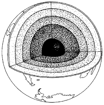
Section through the earth.
The crustal displacement theory envisages
the possibility of periodic displacements of the entire crust in one
piece.
Often less than 30 miles thick, the crust rests on a
lubricating layer known as the asthenosphere.
Gravitational influences
The first of these was the possibility that gravitational influences
(as well as the variations in the earth’s orbital geometry discussed
in Part V) might, through the mechanism of earth-crust displacement,
play a role in the onset and decline of Ice Ages:
When the naturalist and geologist Louis Agassiz presented the idea
of ice ages to the scientific community in 1837 he was met with
great skepticism. However, as evidence slowly gathered in his
favour, the skeptics were forced to accept that the earth had indeed
been gripped by deadly winters. But the trigger of these paralyzing
ice ages remained a puzzle. It was not until 1976 that solid
evidence existed to establish the timing of ice ages.
The
explanation was found in various astronomical features of the
earth’s orbit and the tilt of the axis. Astronomical factors have
clearly played a role in the timing of glacial epochs. But this is
only part of the problem. Of equal importance is the geography of
glaciation. It is here that the theory of earth-crust displacement
plays its role in unravelling the mystery.
Albert Einstein investigated the possibility that the weight of the
ice-caps, which are not symmetrically distributed about the pole,
might cause such a displacement. Einstein wrote: ‘The earth’s
rotation acts on these unsymmetrically deposited masses, and
produces centrifugal momentum that is transmitted to the rigid crust
of the earth. The constantly increasing centrifugal momentum
produced this way will, when it reaches a certain point, produce a
movement of the earth’s crust over the earth’s body, and this will
displace the polar regions towards the equator.
When Einstein wrote these words [1953] the astronomical causes of
ice ages were not fully appreciated. When the shape of the earth’s
orbit deviates from a perfect circle by more than one per cent, the
gravitational influence of the sun increases, exercising more pull
on the planet and its massive ice sheets. Their ponderous weight
pushes against the crust and this immense pressure, combined with
the greater incline in the earth’s tilt [another changing factor of
the orbital geometry] forces the crust to shift ...
The connection with the onset and decline of ice ages? Very
straightforward. In a displacement, those parts of the earth’s crust
which are situated at
the North and South Poles (and which are therefore as completely
glaciated as Antarctica is today) shift suddenly into warmer
latitudes and begin to melt with extraordinary rapidity. Conversely,
land that has hitherto been located at warmer latitudes is shifted
equally suddenly into the polar zones, suffers a devastating climate
change, and begins to vanish under a rapidly expanding ice-cap.
In other words, when huge parts of northern Europe and north America
were heavily glaciated in what we think of as the last Ice Age, it
was not because of some mysterious slow-acting climatic factor, but
rather because those areas of land were then situated much closer to
the North Pole than they are today. Similarly, when the Wisconsin
and Wurm glaciations described in Part IV began to go into their
meltdown at around 15,000 BC the trigger was not global climate
change but a shift of the ice-caps into warmer latitudes ...
In other words: there is an Ice Age going on right now—inside the
Arctic Circle and in Antarctica.
The lost continent
The second connection the Flem-Aths made followed logically from the
first: if there was such a recurrent, cyclical geological phenomenon
as earth-crust displacement, and if the last displacement had
shifted the enormous landmass we call Antarctica out of temperate
latitudes and into the Antarctic Circle, it was possible that the
substantial remains of a lost civilization of remote antiquity might
today be lying under two miles of ice at the South Pole.
It was suddenly clear to me how a continent-sized landmass, which
had been the home of a large and prosperous society for thousands of
years, could indeed get lost almost without trace.
As the Flem-Aths
concluded:
‘It is to icy Antarctica that we look to find answers to
the very roots of civilization—answers which may yet be preserved in
the frozen depths of the forgotten island continent.’
I
hauled out my researcher’s resignation letter from the files and
started to check off his preconditions for the emergence of an
advanced civilization. He wanted ‘major mountain ranges’. He wanted
‘huge river systems’. He wanted ‘a vast region which occupied a land
area at least a couple of thousand miles across’. He also wanted a
stable, congenial climate for ten thousand years, to allow time for
a developed culture to evolve.
Antarctica is by no means a needle in a haystack. It’s a huge
landmass, much, much bigger than the Gulf of Mexico, about seven
times larger than Madagascar—indeed roughly the size of the
continental USA. Moreover, as seismic surveys have demonstrated,
there are major mountain ranges in Antarctica. And as several of the
ancient maps seem to prove, unknown prehistoric cartographers, who
possessed a scientific understanding of latitude and longitude,
depicted these mountain ranges before they disappeared beneath the
ice-cap that covers them today.
These same ancient maps also show
‘huge river systems’ flowing down from the mountains, watering the
extensive valleys and plains below and running into the surrounding
ocean. And these rivers, as I already knew from the Ross Sea cores,6
had left physical evidence of their presence in the composition of
ocean bottom sediments.
6 Ibid. See Part I and Chapter Fifty-one for details.
Last but not least, I noted that the earth-crust displacement theory
did not conflict with the requirement for 10,000 years of stable
climate. Prior to the supposed sudden shift of the crust, at around
the end of the last Ice Age in the northern hemisphere, the climate
of Antarctica would have been stable, perhaps for a great deal
longer than 10,000 years.
And if the theory was right in suggesting
that Antarctica’s latitude in that epoch had been about 2000 miles
(30 degrees of arc) further north than it is today, the northernmost
parts of it would have been situated in the vicinity of latitude 30°
South and would, indeed, have enjoyed a Mediterranean to
sub-tropical climate.
As we see in the following chapters, it might have ... and they
could.
Back to
Contents
or
Continue to Chapter 51
→
|