|

CONTE AND CONTRA CONTE
If it pleases your Majesty, may I present a point and counter point
on the historical use of the Warcop site by the Army: - and its
current and future use.
N.B. All comment printed in small point, ‘Times New Roman’, has been
taken verbatim from the public domain, MoD or other Government
sources. Access to certain material has been limited by the needs of
National Security, and by Act of Parliament. For any error that
might accrue because of the above, I apologise for unreservedly, in
advance. I would also like to stress, Ma’am, that this is not a case
of ‘N.I.M.B.Y’, by one of appositeness and sanity.
HISTORICAL
“Warcop Training Area was established in 1942 as a tank gunnery
range, which was urgently needed to prepare for the coming invasion
of mainland Europe. As in many other parts of the country, this
meant that a number of farms had to be evacuated.”
Warcop, Sandford and Bleatarn Parish magazine added this comment: -
“The Pennine range forms the eastern boundary, which during the war
attracted the MoD who commandeered some 4000 acres as a firing
range, which quite recently has been extended towards Stainmore.”
In truth, Ma’am, what happened, was that during World War Two, the
Allied Forces needed practice areas for the Normandy invasion, areas
that were well away from Third Reich aerial surveillance, so they
commandeered a number of sites to be used as practice areas, for the
duration of the war. At that time, the Army gave its assurances,
that the land borrowed for the purpose, would be returned to
civilian ownership at the cessation of hostilities: - at Warcop,
this never happened, instead the Army has broken its promises and
retained the land against the wishes of the people.
Ma’am, if I, as one of your subjects, were to commandeer someone’s
home, having made assurances to return it, then failed to do so; I
would be rightfully summonsed by your court, to answer charges of
theft. Ma’am, with deep respect I would like to humbly ask the
question - what makes the MoD believe that it can behave as though
it is above your law? Also Ma’am, as the head of the House of Doves,
who many generations ago, first settled the land in question, it
behoves me to seek to rectify this situation and if possible, to
return the land for the use of the people and to stop the MoD’s
belligerence toward the farming community, who for generations,
farmed the very land the empire building Mandarins of the MoD has
set their avaricious designs upon.
PHYSICAL DESCRIPTION OF THE WARCOP RANGE
The Warcop range, Ma’am, is encompassed by what could be described
as a series of ‘natural boundaries’. From which it forms a
rectangular landmass of approximately ten kilometres by eighteen
kilometres. The south-eastern boundary is the B6276, Brough too
Middleton-in-Teesdale road. The south-western boundary is formed by
the A66 Brough too Appleby road. The north-western boundary is a
line that is taken from the town of Appleby, up through the world
famous geological feature of the High Cup Gill, using the Maize Beck
as the natural boundary, down to the great cataract of Calderon
Snout, the highest waterfall in England. The final north-eastern
section is bounded by the River Tees itself, as it flows over the
High Force, the largest waterfall in England, and down too
Middleton-in-Teesdale. Five-sixths of this landmass is composed of
High Fell country, which is dominated by moorland, crevasse and wet
bogs. It is a treacherous place for the unwary and inexperienced, as
there are a fair number of disused old mine workings scattered over
the entire area, which form a considerable hazard for anyone using
the Fells.
The remaining sixth of the range is in an area of gently undulating
land, referred to as the Low Fells and comprises of a relatively
narrow strip of once very arable farm land, that lies between the
uplift of the High Fells main Pennine ridge and the A66 road.
Because of the confinements placed upon the area, imposed by the
close proximity of the River Eden to the Pennine uplift, the land
either side of the old Roman road [A66] abounds with archaeological
and historical evidence of over three thousand years of intense
human activity. The whole area is one of outstanding natural beauty
and historical interest, with abundant wildlife, both inside and
outside of the military boundary.
ISSUE ONE
Ma’am, I am sure that you are well aware. The role that the MoD has
to play in our modern world has become far more complex than
formally. The demands placed on it by the State, means that with a
drastically diminishing number of regiments, it has to fulfil an
ever increasing policing and defensive role, with far less manpower.
A logical response to this has come with the introduction of ever
more effective equipment. The use of this equipment requires
training and the space to train. However, there is a requirement
here for logic to be used by the armed forces and not panic.
For instance. the needs for the Vickers Defence Systems ‘Challenger
II’ battle tank, to be able to fire at a target while on the move
and at speed, creates very difficult logistical problems for the
MoD. The main 120mm gun of the Vickers Defence Systems ‘Challenger
II’, when elevated to 20°, has the ability to fire a projectile, up
to four times further than the total width of the Warcop range, and
as every range needs a very necessary safety zone around it, to
absorb the odd overshoot or ricochet etc, which should be
sufficiently extensive so as to cater for all the weaponry fired on
it, including missiles. This would mean that the total area needed
for a heavy ordnance range, would be very substantial indeed,
therefore hundreds of square kilometres would be needed, and these
needs must be addressed. However, to think about putting such heavy
ordinance in a very heavily occupied rural community, is, to put it
succinctly: - insane.
With the larger gun Ma’am, that is to be fitted to the next
generation of Challenger II’s, it would mean that the new gun could
command a 40 km radius, from any given point [not including the
safety zone], which if measured from the centre of the Warcop
practice area, would encompass an area sufficiently large enough, to
include the towns of Penrith, Kendal, Appleby, Barnard castle,
Reeth, and Hawes, and this is not including the many thousands of
other habitations that would be encompassed within this arc; they
are too numerous to list. But the problems experienced by the United
Kingdom are not unique; they are shared by all other NATO nations.
This dichotomy has been resolved in part, by friendly, former Common
Wealth nations sharing the costs and facilities, as in the case of
Canada for instance, where the United Kingdom shares truly vast tank
training facilities near Alberta with Canada, and the United Kingdom
have a number of battle tanks permanently stationed there, for
training and tactical disposal, as they have in Germany, from whom
the United Kingdom had the right to use the practice area in Poland.
Which as General Sir Roger Wheeler concisely put it: -
“So far as Germany is concerned, there is enormous value in being
there although we are not there to fight any longer, because we are
very much alongside our NATO allies and exercising with the allies
that might be with us in some future war situation, and that is a
very important part of the location of that division” [House Of
Commons Hansard Debates].
We have similar arrangements with South Africa, and Australia, where
we share their extensive ranges and after all they do have vast
uninhabited areas, where guns can be fired great distances, in
relative safety, and where high explosive rounds impacting, will
only frighten a few lizards. Although, in this section, I have used
the model of a heavy battle tank, Ma’am, the situation is similar
with all heavy artillery and this would include the FH70s of the RA,
including those belonging to the Territorial Army RA. It strikes the
logically minded; that to bring Territorial Army RA units from as
far afield as Brighton, all the way to the Warcop practice area for
‘dry’ practice, just to have the gunnery officer pull the chain and
shout “bang”, which would seem to be the case, it stretches
credulity, they could have done that on Brighton beach.
ISSUE TWO
There is an additional problem for the military, that is, where to
store mothballed equipment and munitions, which will be wanted by
the rapid reaction groups in an emergency, as in the Gulf crisis.
Fundamentally, Ma’am, a rapid reaction group, needs its equipment to
be reasonably close to major dock facilities and, or, suitable
airfields, so that it can be deployed ‘rapidly’. A number of sites
have been earmarked for this facility, such as Salisbury Plain,
BATUS, Suffield, Stamford, Sennybridge, Donnington and Marchwood,
whose excellent and underused facilities, make it the Governments
favoured choice at the moment [House Of Commons Hansard Debates].
Surprisingly Ma’am, someone in Parliament suggested Warcop as being
a suitable site, to hold the heavy equipment needed by the rapid
response units. Even though it is in the physical centre of the
island, many dozens of kilometres away from any port facility, or
airfield of any capacity, and now served only by the A66 which, as
anyone who has driven the route knows, is an exceedingly dangerous
road, which is often so adversely affected by weather conditions,
that it needs 2m high snow poles, to mark where the road is supposed
to run. It is such a dangerous road, that questions about its safety
have been asked in parliament. If this was not problem enough, when
the Warcop practice area was downgraded and the rail connection to
the Warcop site was closed and sold off sometime before 1985, it
made the logistics of moving large numbers of vehicles in and out of
the site more dangerous, than difficult a task and 100-ton tank
transporters are both dangerous and difficult.
Should the MoD, Ma’am, decide to store its extremely expensive
equipment there, it would be doubtful, if the equipment would still
be in a battle worthy condition when needed. Why, because the Warcop
site lacks the suitable heated bunkers, which the cold and damp
imposed by the local weather conditions would require for the safe
storage of such equipment. More importantly, the said
parliamentarian should have consulted the geological data, where
they would have discovered that there is a convergence of fourteen
major geological fault lines in the immediate area, and that these
faults in geological terms are not inactive. Now as far as the
Government guidelines for such things go, it is not recommended to
store ordinance (due to its sensitivity to shock) anywhere near one
geological fault line: - let alone fourteen.
ISSUE THREE
The MoD, being supposedly sensitive to these problems, and to the
demands of the local population in Cumbria, were compelled to close
down their artillery range there and remove the Warcop rail link.
They then down graded the whole site to a general-purpose small arms
range for cadet and TA training; with a target range that had a
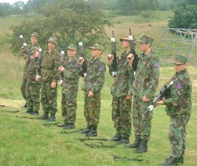
maximum distance of just 600 metres, strictly small bore. Of the
recent visitors to the site, three of the army units we know of who
have used the range, are No 501 (County of Gloucester) Squadron TA.
Leeds University Officers' Training Corps TA and a Scottish cadet
force.
Ma’am, in these days of budget restrictions it, might seem a little
incongruous that the Warcop site is maintained at great cost to the
nation, for the occasional use of Territorial Army and Cadet units;
who have been transported many miles past many similar, or even
superior MoD ranges, much nearer to their bases than Warcop. Leeds
UOTC had to pass the very fine arrangements of Stensall Rifle Range
at York, where five ranges have recently been refurbished, at a cost
to the nation, of £600,000.00. Or again the No 501 (County of
Gloucester) Squadron TA, had to pass Beckingham Rifle Range, at
Nottingham, newly built, at the cost to the nation of £680,000.00.
All of the above units, including the Scottish Cadets, were within
80km of 8-10 other MoD ranges of similar or better capacity than
Warcop and much closer to the home base, therefore much more cost
affective.
All photographs are un-retouched and have been taken from Internet
sites and as such, are in the public domain.
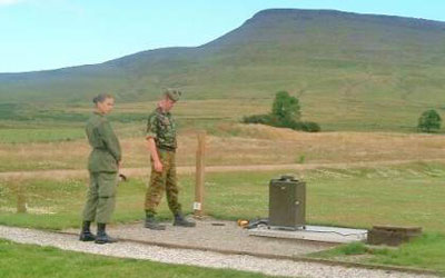
Scottish cadets on the 600 metre shooting position, with ‘Roman
Fell’ in the background, and the villages of Hilton, Dufton, Keisley
and Murton lying just over the hill, a little to the left of centre.
The Druids seat is just above the girl’s head and the Hilton mine is
directly behind Roman Fell.
Drill Parade, Annual Camp at Warcop, July 2000
ISSUE FOUR
Ma’am, by reviewing recent history, it would seem that the MoD’s
actions in Cumbria has not endeared it to the local community. There
are claims broadcast in the media, that the Military has broken, or
is prepared to break, agreements with the farming community,
concerning traditional grazing rights that date back beyond the
eighteenth century. This can be established as fact, as the ‘House
of Commons Hansard Debates’ has recorded: -
“The Army's need to ensure that infantry soldiers are fully trained
for the operational demands of today and the future, makes it
essential that Commoners' Rights on Warcop Training Area in Cumbria
are acquired by the MoD”.
This, they are trying to do by compulsory purchase orders (and
worse). Ma’am, we are not at war and there is no imminent danger of
invasion, so why has the MoD taken it upon itself, to use such
draconian and violent measures against the people of this Kingdom?
Who are they fighting?
Ma’am, this cavalier attitude towards the people on this realm, and
the dubious activities the MoD has become involved in, has logically
ensured that the local and national protest groups have become very
active. Righteous anger is justifiably building against the MoD’s
attitude to both the local farmers rights, and to the public at
large, and the MoD is fuelling this anger by restricting and closing
the access to yet more public areas, even the Pennine Way is
threatened with closure. Nor Ma’am, are the MoD’s attempts to
acquire more land in an AONB helping; containing as they do, well
known and long established NNRS, which have been designated as such
by UNESCO itself, which designation includes the Lune Forest on
Warcop Fell, which incidentally, has been proposed as an SSSI for a
long time, and it is within the established ESA of the Pennine
Dales. In short the presence and activity of the Army in Cumbria has
not won many friends.
It should be noted, that Byelaws made, under section 14(1) of part
II of the Military Lands Act 1892 states that the MoD:
“’can interfere with highways only in exceptional circumstances,
such as when the subject land includes a range danger area. The
Secretary of State for Defence is then empowered to make byelaws
which, given the consent of the responsible highways authority, can
temporarily divert or restrict the use of highways and stop up or
divert footpaths crossing or running inconveniently or dangerously
close to such land. As for common land, no byelaws may be made under
section 14(1) of part II of the Military Lands Act 1892, which take
away or prejudicially affect any right of common”.
And ‘prejudicially affect any right of common’ is precisely what the
MoD has succeeded in doing [House of Commons Hansard Debates].
In their defence Ma’am, it is true that the MoD at the Warcop
practice area has initiated a conservation group, which includes an
agency, NGO and volunteer membership who attends to the lekking
grounds of the Black Grouse, as required of them by Act of
Parliament.
As a footnote, the excessive culling of livestock, and the
deliberate destruction of the field barns along the Western Pennine
edge, is being associated, by the local community, rather directly
and with due reason to the MoD desire to acquire, by default, the
Commoner’s rights and lands for the entire area that surrounds and
includes the Warcop practice area. The locals believe, and with some
justice, that the MoD’s rationale is: - if there are no working hill
farms, there can be no one claiming ‘Commoners rights’, end of
problem. Others contend that the MoD deliberately caused the Foot
and Mouth catastrophe, in order to purchase the land at a blighted
price, and to acquire said grazing rights [Source confidential]. I
have to confess, that although I have researched this subject
thoroughly, for legal reasons, I can find no evidence that points
conclusively to any alternative theory. I fully realise, that the
action, as approved by Parliament, was reputedly designed to prevent
the spread of Foot and Mouth. However 600,000 perfectly healthy
animals being killed around Warcop, requires a better explanation
than, oops sorry.
But the above only stimulates a new question, what has the killing
of privately owned livestock got to do with the security of the
nation, so that it required the farmers who were bereft of their
stock, to be compelled, sometimes by threat, to sign the ‘Defence of
the Realm’ act?
ISSUE FIVE
The main argument put forward by the MoD, Ma’am, for their accretive
attitude towards the Eden Valley, is that they say they are in need
of space to train their troops. In some respects this is true, but I
wonder what is wrong with the military mind, which in its myopic and
dyslectic view, manages to read the words ‘National park’: - as
meaning, ‘Gunnery Range’. From one end of these islands to the
other, there is hardly a single National Park that doesn’t have the
Army’s guns shattering the natural peace that should be found there.
And yes, these are islands, and by that nature, are strictly limited
in area and are having to contend with a burgeoning population, in
desperate need of space, only to have the Army demanding more and
more land, in less and less appropriate places; for an ever
decreasing military force, when it has access to very extensive
ranges elsewhere.
To me, it would seem that the MoD in its arrogance and in total
disregard of the wishes of the people, has become like some
forgotten Japanese sniper, who hasn’t been told that the war ended
in 1945, when it blithely states that the: - “Warcop Training Area
was established in 1942 as a tank gunnery range”, and leaves it like
that, as an open warrant that allows them to do as they like as
though it gives them rights above the law.
The truth is, that the Warcop Training Area was requisitioned by
force, strictly for the duration of the hostilities only. The Army
has since conveniently forgotten its legal commitment to return the
land to its legal owners: - the farming community that it evicted.
ISSUE SIX
CARE OF THE LAND
“The ranges are on low fell, with firing towards an area of high
fell, which acts as an excellent backstop. A steep escarpment
separates the two.”
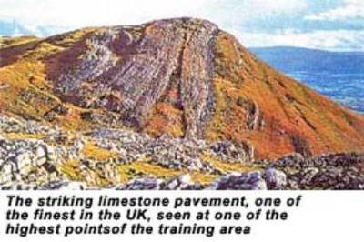
A backstop to what? High explosive shells, that is what, and if that
is caring for the most unique geology in Britain, then the
dictionary needs redefining, as that ‘steep escarpment’; that is so
convenient for stopping shells, is the famous ‘limestone pavement,
one of the finest in the UK’, illustrated above and taken from their
own website.
“The training area is of great interest geologically, and contains
some of the finest untouched limestone pavement in the UK. This
striking rock formation, formed 10,000 years ago during the ice age
and weathered to its current condition, is far better preserved than
other UK sites thanks to the very restricted access for the last 58
years. Care is being taken to preserve it-once damaged it could
never be restored”.
It is stupid, arrogant and insulting, to make such a statement. The
only reason that there is any limestone pavement left, is that they
cannot get their tanks up there. For hundreds of generations, the
local population have lovingly cared for the area, they know how
valuable it is, and have spent large parts of their working lives
keeping it so, only to have the usurper on the land, make arrogant
and embarrassing claims as to its care. It should be noted, that the
area was well looked after for its geological value, long before the
Army closed all access to it, and had been so tended for the last
two hundred years, as it was the prime teaching site used for
geological research, by all the places of higher education in the
United Kingdom and abroad, well before the Army commandeered the
area, and then stopped all access to its geology, even to the point
of making sure that the mines that it closed, were not accessible to
anyone.
They are totally deaf to all points of view except their own limited
sight, and as the Army has a habit of fouling the land it uses, so
likewise, Warcop hasn’t been spared: - note that in their own
photograph (below) which they have published as an example of their
‘care of the countryside’ policy in action, that the damage done by
the tank tracks that criss-cross what was once a corn field, is far
from caring. Incidentally, the area that the Army vainly boasts that
it has preserved, is still the most often cited geological UK site,
and is still part of the teaching module, even though the Army has
illegally prevented access.
Note: this arrangement means that THE most important geological
site in the whole of England is unavailable for research, and is now
rated as only suitable to be a dirt bank on a range, for the Army to
pound with their 130mm heavy guns, and to fire high explosive HESH
and DU rounds at. Ma’am, if I may be permitted to point out that the
Army can do their training, on any of the dozens of better equipped
ranges they already use, and do not need the use of Warcop, or to
destroy such beautiful countryside, prime geology and the life’s of
ordinary people.
Therefore the Army no longer needs Warcop as a gunnery range, as its
requirements have changed. There are the superb gunnery facilities
at Otterburn that it can use, which has the necessary landmass
surrounding it to absorb the needs of big guns. But the Grouse
shooting at Warcop is too good to give up. (See Hansard written
replies).
TRAINING THE ARMY AND PROTECTING THE ENVIRONMENT
(This is the army’s own quote, please note the damage to the
environment, shown in this picture, that the Army is so keen to
boast about)
The sharp hill in the right background is Murton Pike; the similar
hill in the left background is Dufton Pike. If the MoD get their
way, pray to God that they don’t, then Dufton Pike will be in the
centre of the new grounds that the MoD want. Note that, in the far
distance and a little to the left of Dufton Pike is Knock Pike, that
to will also be enclosed by the scheme. At the foot of all of these
Pikes are a series of full sized villages, and all are in range of
the gun, mounted on the vehicle in the picture, and the gun
incidentally, it is capable of firing DU munitions.
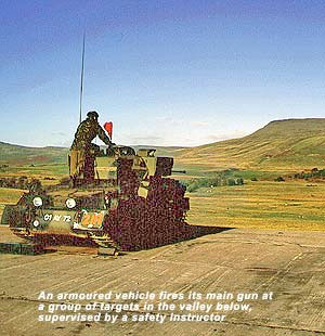
Ma’am, if you would please note that the bluff, visible in the top
right of the picture, is Roman Fell, therefore the vehicle is parked
up on the hard standing 1.25kl due north of Toddygill Hall. If a
line were to draw from the armoured vehicle to the white targets
just visible in the valley just in front of the vehicle, and extend
it, one will find that it dissects the villages of Hilton at 5kl
distant from that firing position, and Murton at 6kl, Harbour Flats
at 7.5kl, and Keisley at 8.5kl, all well within the range of the gun
demonstrated in the photograph and in direct line of fire, the
villages being just over the shoulder of land, immediately above the
targets being aimed at.
No wonder that the army want to buy the land there. But the army has
missed the point, if you chose to fire your guns on land you
borrowed, which is tightly surrounded by numerous towns and
villages, perhaps you should think of moving to somewhere safer. NB:
there are three towns and thirteen villages, all within 3kl of the
range’s present stated boundary, as well as a plethora of farms,
Wicks and Hams etc.
This is a general view of Catterick Training area, please note the
condition of the landscape, and this is with their zero harm to the
countryside policy. As it is the same regiments who did this, are
the ones who want to practice at Warcop. You can guarantee that this
is what Warcop will look like very soon, if they get their way.
Ma’am, I would like to ask the Army, who swore to ‘preserve and
protect’ this land and its people, the Grail question, “Who do you
serve?” evidently Ma’am, by what is being demonstrated publicly, not
the population of the UK, nor the land they live on.
Note, if you were to project this military lunacy further, and take
the Army’s intent to use the 130mm rifled guns on Warcop range, then
the impact zone would encompass all the lands marked out by and
including the towns of Alston, Middleton in Teesdale, Kendal and
Barnard Castle, as all fall well within the range of that gun, nor
can the Army guarantee that there will be one accidents, no one can.
Their own history is littered with misadventures. Can such a risk to
all those innocent people be permitted?
ISSUE SEVEN
CONTAMINATION
The MoD on their website
admit that they do have a:
‘Nuclear Biological and Chemical training centre’ at Warcop’.
What this in reality implies, they do not elaborate on, but usually,
as in the case of gasmask training, it is a situation where small
amounts of real tear gas are introduced to the trainees. We do know
that during the tank training of the 70’s and 80’, hard targets [old
Chieftain tank hulls] were ‘reduced to small scrap’ by the ordinance
used on them. The energy requirement to ‘reduce to small scrap’ a
52-ton tank hull is not slight. During that period there were few
anti-tank weapons available for training purposes, which could
inflict that kind of damage. These were the ‘TOW’ missiles, the high
explosive ‘HESH’ round and the ‘CHARM I DU’ round.
We have now entered highly contentious ground here, but
never-the-less, if we were to take a suppositious point of view, and
consider hypothetically that, at some point in the past, Depleted
Uranium armour piercing rounds [CHARM 1] and others, of the type
used for destroying armoured vehicles, had been used on the Warcop
range, and that subsequently, it had been discovered that, as a
result of this action, incredibly toxic, radioactive Depleted
Uranium Aerosol particles, had been inadvertently dispersed over a
substantial part of the Fells by the action of the prevailing wind.
Had this hypothetical action occurred, then it would be imperative
that the Depleted Uranium particulate did not enter the human food
chain, via the carcase meat of grazing domestic animals. Had this
hypothetical calamity been allowed to happen, then all the animals
within the contamination zone would have to be destroyed, to prevent
human ingestion, and steps would have to be taken to prevent
restocking. It would also be wise to prevent unregulated access to
the contaminated area, until such times as a viable policy has been
put in place, to control the spread of the particulates, that is
hypothetically.
But, Ma’am, did this happen? We could find out by soil analysis,
which might reveal that there could be a percentage of radioactive
particles to be found in the soil that should not be there. The
Government Spin Doctors will point out that there was the Sellafield
accident, and of course there was the Chernobyl disaster, in both
cases it is true that the radiation clouds passed over the Eden
Valley. However, any analysis of radioactive isotopes to be found in
the soil, would reveal which isotopes hypothetically could be
involved. If the analysis were to reveal that it was the depleted
Uranium 238U isotope, and not the reactive Uranium 234U or the 235U
isotopes as used in reactors, then we know with absolute certainty,
that DU weapons have been discharged. We would also find the Uranium
234U and 235U isotopes there, as these are present over the whole of
Northern England, due to the above-mentioned disasters.
So how possible is it, that the MoD could have polluted the High
Pennines illegally, with depleted Uranium, thereby contaminating the
Hill Farmers grazing lands, and polluted the water table that
supplies the whole of the North of England including Manchester,
with a incredibly toxic element, that according to some experts is
more than a million times more toxic than Arsenic, and that as
little as one milligram in the nasal tissues: - can be lethal. How
strong a possibility is this: - very.
But before any blame is apportioned, it should be mentioned that, at
the time of the development of the CHARM 1 projectile, the soldier
in the field and that includes the CO’s did not generally know, the
true nature and toxicity of Uranium Isotopes.
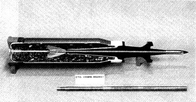
Ma’am, the CHARM I-III rounds are similar to the one illustrated
below, where a discardable sabot containing a metal bolt not
dissimilar to a metallic crossbow bolt, is fired at high muzzle
velocities at a hard target. On impact, the said bolt partly
vaporises and partly penetrates the armour, leaving a dead tank and
a fireball of extremely toxic and radioactive particles to
contaminate the area for 4.25 million years.
Question: has the Army used DU weapons in the Cumbrian district? The
short answer is yes. The Army has used DU on the Eskmeals range in
Cumbria for years, where it has purpose built facilities for DU
testing, and they have more than eight kilometres of coastline as a
DU weapons range, and other testing facilities just across the water
at Kirkcudbright.
The Royal Society had this to say, regarding the use of Depleted
uranium. At Eskmeals and Kirkcudbright.
8.1 At the time this report was being prepared (February 2001),
there was considerable media coverage of the possible effects on the
health of UK armed forces personnel of inhalation and ingestion of
particles resulting from use of depleted uranium (DU) projectiles in
the Gulf and Balkan conflicts of the 1990s. Parts of the MoD ranges
at Eskmeals and Kirkcudbright are set aside for testing of DU
projectiles, although the former site has not been used for some
years. Test firing of DU projectiles at Kirkcudbright (through "soft
targets" out into the Solway Firth) is still taking place. MoD has
indicated to RWMAC its view that the projectiles lodge intact in the
Solway Firth seabed.
8.3 MoD needs to characterise fully the composition of all its DU
munitions. If the presence of other radionuclides is confirmed, MoD
would, in RWMAC's view, need to consider whether fresh work should
be carried out, covering the implications for environmental
contamination at both sites and a reassessment of exposure of the
critical groups. The findings of any new work should be made public.
8.4 The main focus of this part of the main report is on the future
of the DU projectile testing facilities at Eskmeals in the context
of the cost of ongoing radiation protection and environmental
monitoring measures, and eventual clean up. Details of the RWMAC's
visit to Eskmeals and perceptions of the Eskmeals and Kirkcudbright
land ranges are given in Annex 8 of this report. The Annex includes
RWMAC's views on the radiation protection precautions taken at
Eskmeals, environmental monitoring at both sites, site waste
management, and the need for characterisation of ground
contamination.
8.6 The last RWMAC report addressed waste management and
radiological monitoring at Eskmeals in some detail, including the
precautions taken to contain radioactive contamination to the area
of the VJ Battery butt (a near-completely enclosed permanent
structure within which the results of test firing projectiles
against, for example, armour plate, can be observed). During its
visit in July 2000, the Committee observed that the management of
very small amounts of residual radioactive waste arisings and of
some historical wastes still present on the site, the radiological
protection precautions taken, and the environmental monitoring
carried out, were all to high standards.
The Part II deals with the risks from the chemical toxicity of
uranium, non-malignant radiation effects from DU intakes, the
long-term environmental consequences of the deployment of DU
munitions and responses to Part I.
RADIOACTIVITY LEVELS AT WARCOP
Ma’am, the geological strata that composes the greater part of the
Warcop site, is shale; sandstone and limestone, none of these are
renowned for being radioactive, quite the contrary in fact. There is
a volcanic intrusion that dominates the site known as the Whin Sill.
Volcanic rocks are sometimes radioactive, as in the case of the
granites of Cornwall that emit Radon gas. So in order to determine
the radioactivity of the site, I contacted the British Geological
Survey who sent this reply:
“There are data for the Whin Sill, but these are not collated in a
readily accessible form. They would have to be retrieved from a
number of sources. This would take a little time and we would have
to make a charge.
However, I can say that the natural radioactivity levels of the Whin
is low compared to the rocks it intrudes and well below average
crustal levels.
Dr David Jones. British Geological Survey”
Later I found the DoE’s report, which shows that there was a
difference in local levels. I should point out that these are
averages and do not cater for ‘hot spots’, which is what we would be
looking for.
Department for Environment, Food & Rural Affairs
Quarterly Average Gamma Radiation Dose Rates
April to June 1999 (All readings in microGrays/hour)
|
Monitor |
Normal Level |
Mean |
Standard deviation |
Minimum |
Maximum |
|
Warcop Range |
0.10 |
0.0988 |
0.0046 |
0.09 |
0.12 |
|
Lydd |
0.07 |
0.0751 |
0.0058 |
0.06 |
0.12 |
|
Exeter |
0.15 |
0.1452 |
0.0055 |
0.13 |
0.17 |
|
Lydd Airport is on a sedimentary landscape, similar to the
sedimentary rocks of Warcop. The radiation levels of sedimentary
rocks are normally so low, as to be in radiological terms “minimal”.
However, the above diagram illustrates that the claimed ‘normal’
levels at Warcop, are nearly a third higher, than the levels at Lydd
Air Port. It may only be a differences of.03, but it is a difference
that shouldn’t be there. Depleted Uranium is not only highly
radioactive: - it is extremely poisonous and it can easily poison a
water table.
When we look at the figures below, again, there is that small lift
in the figures that needs questioning. Carlisle is situated on
ground that was deposited by glacial action from the Eden valley; so
theoretically, it is the same rock, only, ground to silt, and
theoretically it should be slightly higher in background radiation,
as it is at the point where heavy metals would be deposited by the
rivers, due to it’s closeness to the marine water table, and the
lack of movement of the same. I therefore conclude, that there is a
rise in the background radiation present on the Warcop site, which
has no geological genesis.
The Department of the Environment, Transport and the Regions,
published ‘RIMNET’ table 5.18(a) that showed the average gamma
radiation dose rate for Phase 2 RIMNET monitoring sites: County
Average annual reading1998 mSv/yr
|
Carlisle |
Cumbria, 0.61 |
|
Warcop Range |
Cumbria, 0.63 |
|
Lydd |
Kent, 0.48 |
|
Therefore, it has to have another genesis point, other than the
Sellafield or Chernobyl disasters, as the elevated figure, present
at Warcop, fails to show up at Carlisle, and in fact Carlisle would
have been subjected to the same degree of Sellafield or Chernobyl
fallout as Warcop.
Ma’am, if you would forgive my bluntness, to me it is obvious, that
the military presence at Warcop Practice Range, does present a clear
and present danger to the lives of millions of innocent UK citizens,
and that the Army must not, under any circumstances, be allowed to
put millions of lives at any further risk, by contaminating any more
of the major catchment area, that provides drinking water for the
whole of the North of England, with highly toxic compounds, that are
there, basically forever. The only way to prevent this from
happening, is to make sure that the Army is not present on those
hills.
FUTURE
All quotes have been taken directly from the MoD Training Area’s own
web pages and other official sources. The replies are my own, but I
do voice the opinion of the many.
The MoD has expressed a wish to increase the size of the Warcop
Training Area for training purposes. On paper, this looks innocuous
enough, but in reality, the MoD wishes to double their land holdings
in the area. However, the rationale behind their hopes and
aspirations is as invalid, as it is feasible to make it. A reference
to any reliable map of the area, would instantly demonstrate that
the phrase:
“Adjacent to the main A66 road as land becomes available, and to
purchase additional farmland immediately west of the training area
boundary.”
Would demonstrate that the MoD is endeavouring to acquire a second
block of land, of about 23,500 acres immediately to the west, of the
present range, which is also about 23,500 acres, thereby doubling
it’s holding around the town of Appleby.
“The Army hopes to continue acquiring plots adjacent to the main A66
road as land becomes available, and to purchase additional farmland
immediately west of the training area boundary. Such small-scale
purchases enable valuable additional training to be undertaken with
little or no impact on the surrounding population.”
This strange and highly fictitious remark, regarding the local
community’s intelligence and well-being is as insulting a remark as
it is possible to achieve, and only demonstrates the high level of
contempt that the MoD hold the local populous in. The only land that
will ‘become available’, is the land where the owner has been forced
to stop farming, because someone has shot all their livestock and
pulled the roofs off the hill barns, all in the name of Her
Majesties Government.
Ma’am, if you would me kind enough to glance at the relevant map, it
would show that for the MoD’s plans to be possible, the MoD would
have to engulf the villages of Murton, Hilton, Dufton, Keisley,
Brampton, Knock, part of Warcop and half the town of Appleby. As
they are inconveniently situated exactly where the MoD wish to
expand into. Still, all those listed buildings will give the Army
demolition experts something interesting to play with.
David Harrison, the environmental correspondent for the Sunday
Telegraph, wrote:
“The Army is planning to use a large and beautiful stretch of the
Pennines for training exercises with Challenger 2 tanks, armoured
vehicles and other heavy weapons. The proposals have provoked
opposition from countryside groups and residents who say that the
gunfire will shatter the area's tranquillity, damage the landscape,
restrict public access and destroy traditional farming. The Ministry
of Defence (MoD) says that the land in Cumbria is "desperately
needed" for exercises by 5,000 soldiers at the Infantry Training
Centre in Catterick, North Yorkshire.
The row centres on 60 square miles near Appleby-in-Westmorland, a
designated area of outstanding natural beauty with classic Pennine
features: heather moors, marshland valleys and fells higher than
2,000ft. The Army has carried out small-scale training in the area
since 1942. The villagers have set up a fund to help them raise
money for the fight. In the meantime farmers are exercising their
commoners' rights and disrupting Army training on Warcop”.
The British Army complains that it hasn’t enough space to play in: -
this is grossly untrue. If you were to add 300 sq miles of Salisbury
Plain to the Castle Martin’s area, and that of Otterburn, Catterick,
and Lulworth, you would have a tremendous 440 square miles to play
in. Then you could add Dartmoor, Bovington, Tidworth, Warminster,
Sennybridge, Stamford, Oakington, North Luffenham, Ludford Cove,
Ouston, Stanford and the Brecon Beacons, and then the size of the
playground becomes unbelievable. My list ends here, but the real
list is even greater and I haven’t even started on Scotland, with
its vast under populated areas, it then adds up to a figure that is
close to 1,000 square miles; that’s an unbelievable one thousand
square miles of this realm, devoted to the sole use of the Army.
That is more than five times the area than Prince Rainier has for
his whole principality to do everything in, population and racing
track included.
Ma’am, to this mind-cracking sum, we can add the undisclosed area
used in the British Army Training Unit, Suffield (BATUS), Canada, or
the Drawsko Pomorski training area in Poland, the Hohne range, the
Grafenwohr and Hohenfels training areas in the south of Germany, and
we could add the South African range and the Australian one, then we
are now looking at possibly twice that figure, and yet the MoD say
they haven’t enough land.
Anybody Ma’am, who under these circumstances says that they haven’t
enough land to train on, is either empire building, inefficient or
running a second agenda that has nothing to do with the defence of
the realm.
Ma’am, I beg you to listen to my plea, and to look on it with
favour, please allow the people of Cumbria who are your loyal
subjects, to have a real opportunity to enter the new millennium
with hope and not despair. Please give the people of this land a
chance to build a new university in the Upper Eden Valley, that will
not only help the people of Cumbria, but also help all the people of
this land, and not destroy it as the MoD’s plans for the area most
certainly will. Please allow the people of this land to create a
wildlife park for the enjoyment of all, which will give a real
chance for survival of criminally endangered native animals, and
please permit your loyal subjects to start new and fruitful lives
that are full of hope in a future, and not the dread despair that
they face now: - it is in your Royal Command and prerogative for you
to do these things.
Ma’am, I hopefully await your reply, ever, your loyal and obedient
servant.
Written this 23rd day of August 2002
by Richard Anthony von Hymir de Dufton
Go Back
|