|


5 April 2005
|
When the
Eurasian tectonic plate tilted upwards during the 90
second earthquake on 28 March 2005, it created a brand
new island offshore Sumatra. We can use this new island
to prove that the March quake was real, and also to
prove that the fake quake of December 26, 2004, was a
nuclear war crime on an unprecedented scale.
|
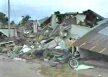
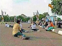
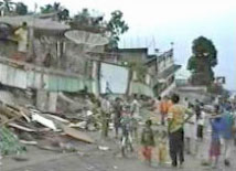
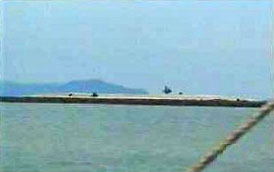
In the center frame,
Sumatran citizens sit on an undamaged road surface after the faint
13-second "Richter 8.5" nuclear tremor on 26 December 2004. Now
compare this frame with those on the left and right, both of which
were taken immediately after the 90-second Richter 8.7 earthquake on
28 March 2005. Complete shock, awesome property damage, and, as we
shall see later, a brand-new island offshore Sumatra.
When the earth roared for 90 seconds
late in the evening of March 28, two events follows swiftly on its
heels. The first was easily the most obvious, with thousands of
buildings destroyed on the Island of Nias and on West Sumatra. Much
further east, building collapsed as far away as Medan, and several
large concrete structures cracked in Malaysia and Thailand.
The second was that as a direct result of media brainwashing in
December 2004, national governments including Thailand and Sri Lanka
swiftly sent out makeshift ’tsunami warnings’ to all of their
coastal towns. This second action caused at least four deaths
through panic that could easily have been avoided, because an
earthquake at a convergence fault like the Sumatran Trench,
cannot
create a tsunami under any circumstances.
This curious reality was discussed at some length in my earlier
tsumani reports, but as a brief refresher, a convergence fault is
where one tectonic plate slides under the other. There is no giant
collision, but instead, the shattering roar of one huge plate
grinding along the underside of the next. Both plates are
underwater, so although one might rise slightly, the other will drop
by exactly the same amount, each displacing (taking up) the same
quantity of water. As a result, excess water displacement, essential
for any tsunami, is zero.
All of a sudden, at the end of March, western scientists were faced
with the impossible task of explaining why the December ’earthquake’
(originally declared by NOAA as 8.5 on the Richter Scale), had
produced a deadly tsunami, but the more powerful 8.7 real earthquake
at the same epicenter in March, had not. Faced with mission
impossible, the scientists followed the established media lead, and
invented lies they thought sounded plausible. As the London
Independent newspaper noted on March 30:
"Scientists are still grappling with
the mystery of why such a large earthquake under the ocean did
not produce a sizeable tsunami. One thing is certain, however,
the Earth did not move as it did on Boxing Day when 10m-high
waves killed up to 300,000 people around the Indian Ocean.
"Brian Baptie of the British Geological Survey in Edinburgh said
that it would take some days before seismologists can work out
precisely what happened on Monday when northern Sumatra was
rocked by an earthquake that measured 8.7 on the Richter scale.
’It is very difficult at the moment to understand why there was
not a tsunami following an earthquake this size. One possibility
is that its epicentre may have been deeper.’ "
Because the shock effects at the surface
were fully 8.7 in nature, and measured as such by both Indonesian
and Indian seismic stations, Baptie was either lying or perhaps
merely ignorant. But others followed his lead, and the NOAA and
media then arbitrarily upped the December nuclear event to a
ridiculous 9.3 on the Richter Scale, hoping that the bigger number
might help to fool television viewers.
In order to confuse things still further, the BBC showed a graphic
in which it moved the December epicenter further north, and the
March epicenter further south and east, thus creating the television
illusion that the two events were 200 miles apart, and were
absolutely NOT connected to each other. Complete rubbish of course.
As the chart below reflects, both the Indonesian and Indian seismic
stations show the same epicenter for both events.
In the immediate aftermath of the
December thermonuclear explosion in the Sumatran Trench, the media
was groping around for a parallel event, especially after the Indian
Government pointed out harshly that "We don’t have tsunamis in the
Indian Ocean". Clearly the Indians had to be put down swiftly,
before the western public has time to become justifiable suspicious.
How to do this? Easy, the media invented a fraudulent ’giant
tsunami’ precedent dating back to 1833. Believe me, only the mighty
New York Times is allowed to rewrite history in this manner.
At the time of the 1833 earthquake, the locals were more than
capable of being able to read, write, and keep accurate journals of
events. So were the Dutch colonials authorities in Batavia (now
Jakarta, Indonesia), who back then were much admired for their
meticulous book keeping. There are copious written records of
property damage caused by the earthquake itself, but not a single
word about any tsunami at all. So either the Dutch Colonial
authorities were lying in 1833, or the New York Times is lying in
2004/2005. You choose whichever one you think is the most likely
culprit.
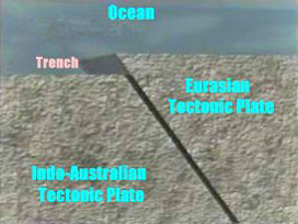
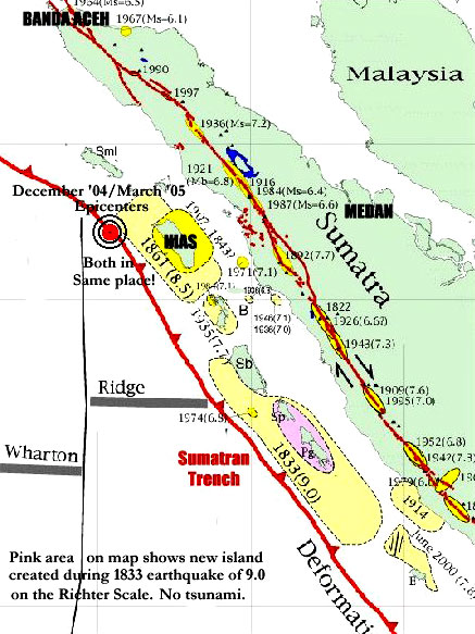
During the undisputed 9.0 earthquake of 1833, a new island was
raised out of the sea offshore Sumatra, represented in pink on the
chart shown above. This happened simply because the western edge of
the Eurasian Plate tilted upwards, as the Indo-Australian Plate slid
underneath it, thereby exposing more of the Eurasian Plate seabed.
So this new ’island’ had always been there, with the tilting plate
finally exposing it above the old high water mark. A bit like the
tide going out, but never coming back in.
One hundred and seventy-one years later, during the March 28
earthquake, another much smaller island was exposed on the Eurasian
Plate to the west of Nias island, which is entirely predictable when
you think about it. The Eurasion Plate had tilted up slightly again,
but not as much as it did in 1833, because this most recent event
measured only 8.7 on the Richter Scale. This is a hundred times less
powerful than the monster 9.0 earthquake of 1833, so smaller quake =
smaller upwards tilt of the Eurasian Plate.
The implications of this simple truth for the conniving liars in the
western media are both obvious and disturbing. They have now
collectively and fraudulently raised the Richter reading for the
December nuclear event from the original 6.4 recorded by both the
Indonesian and Indian authorities, through giant creative leaps to a
current high of 9.3, which in turn is a hundred times more powerful
than the monster earthquake of 1833.
Fine, using basic math (which unlike physics is not theoretical),
and knowing the average depth of the continental shelf to the west
of Sumatra, we can prove that a "9.3" earthquake would permanently
expose at least 60,000,000 more acres of seabed. In fact, you could
now walk all the way from Aceh to Nias Island without getting your
feet wet, provided you followed a semi-circular route.
The fact that you cannot make this walk, simply proves conclusively
that the media and its tame prostitute ’scientists’ have been lying
all the way for the USA. This is probably essential for those who
authorized and executed the monstrous Boxing Day war crime, and who
don’t want to get caught with their nuclear pants down, having
already murdered more than 300,000 Asians with a single
thermonuclear weapon. Moreover, bearing in mind the position of the
Pacific Trenches relative to Japan and China, these clinically
insane madmen may mave more mass murders in mind, using very similar
techniques.
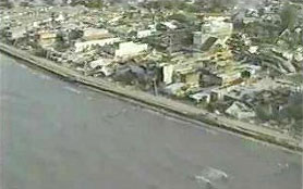
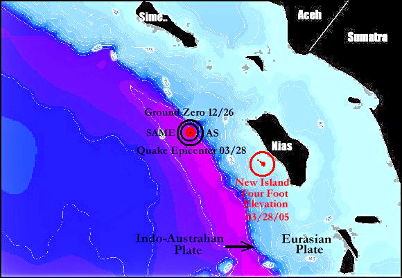
The left frame shows
the coastline of Nias Island, which is now nearly two feet higher
out of the water after the 90-second earthquake on March 28. More
convincing is the right frame, which shows the ’new’ island out to
the west of Nias, and thus closer to the extreme western edge of the
Eurasian Plate. Before the earthquake on March 28, this structure
was a 6" coral reef, completely submerged at high tide. Now at high
tide this reef has been transformed into a new island, with an
overall elevation of 4’ 10". The black band around the base, shows
clearly how much of the seabed was permanently lifted out of the
water by the March 8.7 magnitude earthquake.
The media is not overwhelmingly clever,
but simply exploits the obvious fact that 99% of its viewing and
reading public are not specialists in urban warfare, or aviation,
nuclear weapons or tectonic plate movements, and so on. This
knowledge has served the media’s masters very well, or at least it
used to serve them very well, until the Internet started to really
blossom out around the world.
Nowadays there are thousands of experts, many of them retired with a
lot of time on their hands, who derive considerable pleasure from
exposing these media lies and deceptions. It has almost become a
sport, in which the establishment media side is steadily losing more
and more games to the increasingly professional teams of Internet
independents.
With stories like the Sumatran Earthquake, the establishment media
does the best it can, hiring two-bit junior scientists and magicians
to try and keep you fooled for longer, but in the end they are
undermined by real science on the Internet. And the big trick right
now (in fact the biggest game in town) is to make you believe that a
Richter 6.4 earthquake on December 26, created a massive tidal wave
powerful enough to murder 300,000+ people, while the infinitely more
powerful Richter 8.7 earthquake on March 28 barely rippled the
waters of the Indian Ocean. Hence the fraudulently increased Richter
values, and creatively moving the single real epicenter to two
different positions, 200 miles apart.
It does not stop there. The public in general keeps asking more and
more awkward questions, leading to the media being obliged to
elaborate on its basic lies, sometimes in truly hilarious fashion.
This was particularly so when one scientist (I use the term
’scientist’ in its loosest sense), did a global piece in which he
used graphics to explain how the December 26 ’earthquake’ managed to
cause the giant tsunami that murdered 300,000+ people. Take a look
at the two frames below, which I ’grabbed’ from his television
presentation:
The television
presentation was a moving graphic, out of which I extracted just a
few still frames, but it is essential to remember that it is the
motion of the graphic itself which causes deliberate subliminal
illusions for your eyes and brain. To understand how and why, you
must first record the entire sequence on tape, then single out the
most obvious frames for close examination, which I have done for you
with the two frames shown above.
The predictably boring ’scientist’
started by telling television viewers that it is "water
displacement" which causes all tsunamis. As with most media
deceptions, this was part truth and part lie, making it far more
difficult for a layman to decode.
Water displacement happens all the time in the deep oceans, for
example giant underwater landslides on mid-ocean ridges etc, but
these do not and cannot cause tsunamis, because of Archimedes’
Principle, which I explained in detail in the earlier tsunami
reports.
To recap briefly, when two large submerged objects change position,
they are merely exchanging their water displacements. Because no new
rock has been added to the ocean floor (as it would be in the case
of a new volcano, for example), there is no EXCESS water
displacement to increase the level of the ocean, and lots of
excess water is essential for any tsunami. So, no excess water
displacement = no tsunami. It really is as simple as that.
Somehow the establishment media had to reverse this truth and make
you believe the opposite, which is where the illusory moving graphic
shown on television last week comes into the picture. In the
left-hand frame, the ’scientist’ was explaining that in the Sumatran
(also known as "Suma" and "Sundra") Trench, the Indo-Australian
tectonic plate had slid beneath the Eurasian tectonic plate, which
of course is true. But then he said that this action had raised the
entire Eurasian tectonic plate so far, that water displacement
caused the tsunami. This was a bare faced provable lie, and the
point at which the heavy illusion was triggered.
As any advertising executive or psychologist will confirm, the human
eye is first drawn to the top-right hand corner of a page, which is
why this premier position commands a higher advertising price than
(say) the lower left-hand corner. Now take a closer look at the top
right-hand corners of the two frames above, which were grabbed by me
from the moving film. What do you see, or, more importantly, what
does your brain think that it sees?
In the left frame you can see the Indo-Australian plate start to
slide diagonally to the right underneath the Eurasian plate, with
the Eurasian plate starting to rise (tilt) slightly as a result. The
right frame was grabbed about two seconds later, showing the
Eurasian plate rising up even further, and apparently squeezing the
ocean out of the top of the frame. So the illusory subliminal
suggestion at this stage, is that the water above the Eurasian plate
is being squeezed out above sea level, and thus causes a tsunami.
In order to drive the first illusion home, this footage was
immediately followed by another moving graphic of a huge wave-train,
allegedly the ’tsunami’ resulting from the first illusion. You can
laugh as much as you want to, but this is no laughing matter. About
99.9% of the viewing public saw this event only once at 35 frames
per second, and it would have been very convincing for all viewers
without any real knowledge of Archimedes’ work.
The two still frames above expose the illusion for what it really
was. If you study them carefully for a few seconds, your eyes and
brain start to see the whole picture, rather than merely catching a
glimpse of the preferred top right corners. As the Eurasion plate on
the right rises, the Indo-Australian plate on the left sinks
downwards exactly the same distance. Because the two plates are in
contact with one another, it is impossible for them to do anything
else. Have you got that bit?
Fine, now look at the actual area of ocean in each frame very
carefully, remembering that both tectonic plate structures are
completely submerged under water. As the Eurasian plate rises, the
water above it simply moves to the left, in order to fill the exact
same void volume space left by the sinking Indo-Australian plate.
There is absolutely no excess displacement, and without excess
displacement you cannot possibly have a tsunami. Thus we need to
look for an alternative way of generating sufficient energy to
displace the hundreds of millions of tons of water needed for the
December 26 event.
After the December 26
thermonuclear weapon was detonated in the Sumatra Trench, Australian
authorities knocked back all requests for seismic traces of the
event, using stupid excuses like "our equipment wasn’t switched on",
"Australian seismographs cannot record above 8.0 on the Richter
Scale", and "You must ask the American authorities about that". In
other words, Australian officials were ordered to lie to the
Australian public. This was all forgotten on March 28 this year,
when Australian government geophysicists excitedly displayed the
seismic trace of the Sumatran 8.7 earthquake, thus proving their
equipment could read any magnitude, and furthermore proving they
blatantly lied back in December.
Put bluntly, New York has
Australia’s officials by the balls.
Because the required energy is so huge,
only one other device known to man could have caused the rapid blast
expansion needed to temporarily displace this huge volume of water
and send it surging across the ocean towards India’s two advanced
(Russian) nuclear reactors on its Tamil Nadu coastline, and towards
India’s advanced (Russian) Sukhoi 30 fighters allocated to the
Nicobar Islands in the Bay of Bengal. The device in question is of
course the thermonuclear weapon, otherwise known as the "Hydrogen
Bomb". Minimum size required for this event would be 5+ megatons
equivalent TNT, with a more likely practical yield of 8 -10
megatons.
Only two nations on earth have ever developed and tested weapons of
this size - America and Russia. Therefore, in order to find the
culprit we must examine possible motives, and any activity before
detonation which indicated that either America or Russia was moving
into the area prematurely, in order to take military or economic
advantage of the monstrous aftermath of death and destruction caused
by the artificial tsunami.
After careful analysis, Russia comes up with a completely clean bill
of health. Not only has India been a key ally and economic partner
for more than forty years, India is also crucial to Moscow as a
leading player in the new Russia-China-India-Brazil Coalition. So
for Russia to attack India at this point in history would be as
stupid as Russia attacking Russia. Rest assured that President
Vladimir Putin is not stupid.
As explained in detail in my two tsunami reports, America managed to get two large battle
groups into position in record-breaking time from Hong Kong and
Guam
during the festive season. Each battle group was carrying more than
twice the normal complement of Marines, and had recently exercised
for a gargantuan (though unspecified) "Humanitarian Relief
Operation".
My personal assessment of the situation is that taking into account
sea tracks, navigable channels and possible sailing speeds, neither
fleet could have arrived in the eastern Indian Ocean when it did,
unless every ship was literally waiting for the starter’s gun, fully
manned and with steam up.
New York and Washington also had a strong motive, though it is a
little obscure. By forming the Russia-China-India-Brazil coalition,
Putin has completely blocked "Fortress Americas", a Zionist
fall-back plan to isolate the Western Hemisphere if things got too
rough in the Eastern Hemisphere, and overrun South America and Canada
for their mineral resources. If the tsunami had been slightly more
powerful it would have caused a second (and possible third) nuclear
Chernobyl in southern India, thus breaking a critical link in the
new coalition’s chain of command.
The fact that this did not eventuate might have more to do with luck
than science, because it seems the criminals who designed the
December 26 event, genuinely believed that the weapon would be
powerful enough to cause a subduction slip of the stressed
Indo-Australian plate under the Eurasian plate, at the time of
detonation.
If this had actually happened, it would have been virtually
impossible to expose the covert action, because the sharp
compression wave caused by the thermonuclear weapon detonating,
would have been mixed up with the 90-second jumble of transverse
shear waves on the seismograph, exactly the same as those shown
above for the March 28 quake.
Fortunately, it seems likely that ’God’ has left the side of these
homicidal ’Christian’ crusaders, and although placed under enormous
nuclear stress, the two mammoth tectonic plates managed to stay in
their correct positions, though unquestionably weakened. During
January and February more than 100 significant events further north
towards Chittagong proved that the integrity of the Sumatran Trench
had been seriously compromised, and then on March 28, the deep
portion of the trench where the nuclear weapon was detonated finally
gave way, with the Indo-Australian plate sliding several yards under
the Eurasian plate.
And here you have the final proof. If there really had been a
’Richter 9.3’ earthquake on December 26, the enormous pressure
between the Indo-Australian plate and the Eurasian plate would have
been relieved completely by the quake, leaving the Sumatran Trench
stable for another 50 years or so. Minor aftershocks of course, as
the zillions of tons of tectonic plates ’bedded in’ again, but
absolutely no major events like March 28.
The Declaration of Independence makes it
abundantly clear what is expected and demanded of all American
citizens when an elected Government moves to quash their unalienable
rights, or acts illegally in any other way including war crimes:
"when a long train of abuses and usurpations, pursuing invariably
the same Object evinces a design to reduce them under absolute
Despotism, it is their right, it is their duty, to throw off such
Government, and to provide new Guards for their future security."
Understandably perhaps, the authors of the Declaration could
scarcely have envisioned the day when an elected Government would
become completely subservient to a bunch of Wall Street bankers
instead of the ’governed’, which would then invent fictional
terrorist organizations in order to remove the unalienable rights of
the ’governed’, and finally order the brutal murder of more than
300,000 people in South and South-East Asia with a single nuclear
weapon. Back in 1776, such blatantly obvious abuses of power would
have seemed ridiculous.
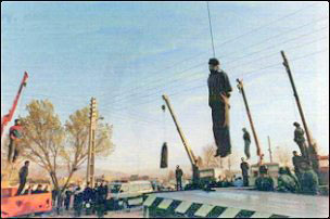
Though there are no hard and fast rules
on exactly how the governed are expected to carry out their duty in
respect of the above-noted high political crimes and treason, it
does seem unreasonable to ask the American public to go to the
trouble of building several wooden gallows on Capitol Hill, when an
abundant number of mobile cranes are readily available today at low
hire rates. The center picture above shows five Iranian drug pushers
after sentence was passed and carried out.
Back in 1978 the Shah of Iran was the biggest global drug pusher of
all, and like most American politicians today, would have scoffed at
the prospect of he or his fellow criminals ever being brought to
justice by ’ordinary’ Iranian people. Though the Shah managed to
escape the country in 1979, most of his murderous cohorts and
collaborators wound up hanging from cranes less than five days after
the Revolution started. These abusive Iranian officials were deluded
into believing they had absolute power over the people, but slowly
choking to death at the end of manila hemp ropes proved they did
not. History is full of such examples.
American politicians and officials must be executed with the same
attention to detail as any other common criminal, so the ’governed’
should make sure that correct protocol is followed. The traditional
American hangman’s noose has from five to thirteen coils, which
slide down the rope delivering a heavy blow to the side of the neck.
The modern American coiled noose is prepared in accordance with a
procedure laid down in a US army manual, from 30 feet of 3/4" - 1"
diameter manila hemp rope, boiled to take out stretch and any
tendency to coil. It is formed into six coils and then waxed, soaped
or greased to assure that the knot slides easily.
It seems unlikely that the American public in general will be
sufficiently motivated to take action for at least another year (or
when crude oil prices exceed $100 per barrel), but this does not
mean that you personally cannot prepare yourself for the day when
New York and Washington’s murderous master criminals are brought to
justice. If you have time on your hands and a little spare cash, why
not drive down to the hardware store and buy a 30’ length of manila
hemp rope? Pick up a can of axle grease from the gas station on your
way home, and then use the twilight hours to grease your rope, and
learn how to fashion a really good hangman’s noose.
It pays to be ready, and try to remember that this is not a joke, or
even simple vengeance for being abused and suppressed by these
out-of-control fanatics. Removing these criminals from power, and
punishing them for their crimes, is your solemn duty under the
Declaration of Independence.
Return to Contents
|