GLOBAL EXPANSION TECTONICS
Introduction
|
Contents |
Preface
Global tectonics was introduced a number of decades ago as an all embracing science that seeks to quantify and explain the Earth as a dynamic, interactive entity.
As an outcome of this new philosophy we, in all our walks of life, have become accustomed to viewing the Earth globally, be it geology, ecology, climate, population, politics, and so on. Global tectonics however, in its strictest sense, must go beyond the present, or near present, i.e. human scale, and include the geological past, dating back to the formation of the Earth during the Archaean some 4,500,000,000 years ago, and all the Eons in between. In presenting Global Expansion Tectonics it must be realized that the global geological and geophysical database has only now reached the stage where any global tectonic hypotheses can be confidently quantified, challenged, and/or discarded.
Earth expansionists, since the pioneering work of Christopher Otto Hilgenberg in 1933, have known that if all of the Earth's continents were fitted together they would neatly envelope the Earth with continental crust on a globe some 55% to 60% of its present size. This coincidence led Hilgenberg to conclude that terrestrial expansion brought about the splitting and gradual dispersal of continents as they moved radially outwards during geological time. This coincidence has, however, consistently failed to gain recognition within the scientific community as a viable explanation for modern global tectonics. The primary reason for this, in addition to palaeomagnetic based conclusions, is considered to have been the general lack of supportive global scale evidence to quantify accurately a reproducible expansion process with time.
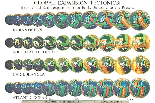
With the advent of modern, global geological and geophysical data Global Expansion Tectonics is presented here as a revitalized, internally consistent, geodynamic hypothesis of Earth expansion which utilizes modern oceanic magnetic isochron data to constrain both palaeoradius and plate reconstruction from Early Jurassic to the present. In the concept of Global Expansion Tectonics, prior to the Early Jurassic, all of the present continental lithosphere was united as a single Pangaean continent, encompassing the entire Earth at a much reduced palaeoradius.
Oceanic areas were represented by shallow epi-continental seas, with the volume of hydrosphere and atmosphere increasing with time, in sympathy with volume of oceanic lithosphere. Very low rates of expansion during the Precambrian suggests a prolonged period of widespread tensional taphrogenesis during the Archaean and Proterozoic, with a period of intense thermal and ductile activity during the Proterozoic, leading to onset of intrasialic rifting, crustal thinning, and intracratonic basin sedimentation during the Palaeozoic.
In order to quantify Global Expansion Tectonics, and accurately quantify any variation in the Earth's palaeoradius with time, it is argued that it is necessary to take into account the area and pattern of oceanic lithosphere generated from Early Jurassic to the Present (e.g. CGMW & UNESCO, 1990), and similarly continental lithosphere during the pre-Jurassic. By moving backwards in time, successively older chron intervals from across active mid-oceanic spreading ridges must be removed, and each of the remaining chron intervals reunited along their common spreading ridges.
The conclusions drawn from consideration of the Earth's lithospheric budget however, hinge on three mutually exclusive considerations; namely:
the surface area of oceanic lithosphere measured represents the total area of new oceanic crust, generated and preserved during the interval of time under study, hence there has been an expansion of the Earth with time, in keeping with Global Expansion Tectonics;
the surface area of oceanic lithosphere measured represents the remnant oceanic crust remaining after subduction has occurred up to the present day, hence there has been no expansion of the Earth with time, in keeping with plate tectonics or;
the surface area of oceanic lithosphere measured represents the remnant oceanic crust remaining after partial subduction on an expanding Earth.
Consideration (1) forms the basis of Global Expansion Tectonics.
The mathematical equations derived from crustal data represent a confirmation and refinement of earlier modeling studies by Hilgenberg (1933) and Vogel (1983) enabling the kinematics of an Earth undergoing an exponential expansion, from the Archaean to the Present, to be readily determined. In contrast, consideration (2) is fundamental to plate tectonics and cannot be reconciled with Global Expansion Tectonics. A value of 24 ± 8 mm/yr for rate of increase in Earth radius (Carey, 1986), calculated from satellite laser ranging measurements, and 18 mm/yr from VLBI and SLR geodetic measurements (Robaudo & Harrison, 1993) while speculative, compare favorably with a value of 21 mm/yr calculated herein using empirical sea floor surface area data.
This secular increase in Earth radius is considered adequate to account for all of the ocean floor growth since at least the Early Jurassic, without the need for consideration of subduction of oceanic lithosphere. Similarly consideration (3), which accommodates partial subduction on an expanding Earth, is also rejected, as the small Earth modeling enclosed empirically negates the need for removal of excess lithosphere by subduction processes.
Introduction To Earth Expansion
There is nothing more contentious in global tectonics at this time than the expanding Earth concept (Owen, 1992).
In order to demonstrate the Post-Jurassic plate motion history of the Earth Weijermars (1986, 1989) and Scotese et al, (1988) used published oceanic magnetic isochron data to produce empirical and computer based plate reconstructions respectively, on a static sized Earth model. During plate reconstruction, both authors were confronted with problems of plate boundary mismatch and constraints to the Earth’s lithospheric budget.
Balancing the lithospheric budget was overcome by introduction of presumed, pre-existing lithosphere in order to maintain a static Earth radius. In order to justify modeling on a static Earth radius, Weijermars (1986, 1989) in particular, provided "six conclusive arguments against any fast Earth expansion hypothesis", prior to modeling studies.
This, unfortunately, did not scientifically resolve the argument that modern oceanic magnetic isochron data may in fact be better modeled at reduced Earth radii.
Graphic of the Earth expanding (by James Maxlow)
Estimates of palaeoradius from palaeomagnetic data (eg. Egyed, 1960, 1961; Cox & Doell, 1961a, 1961b; Ward, 1963, 1966; van Hilten, 1963, 1968; van Andel & Hospers, 1968a, 1968b; McElhinny & Brock, 1975) were, and still are, considered by palaeomagneticians as limiting the amount of potential Earth expansion to less than 0.8% during the last 400 million years.
Crater distributions and ages on the lunar surface (Taylor, 1983, 1984) were also considered to rule out any significant expansion of the Earth or Moon during the last 4 billion years, and similar conclusions were applied to Mars, Mercury and Venus (McElhinny et al, 1978; Taylor, 1983, 1984).
Similarly biogeographic distributions of invertebrates during the early Palaeozoic (Burrett, 1983; Condie, 1989) were considered to be incompatible with an expanding Earth. Limits to palaeogravity since the late Precambrian (Stewart, 1978) were said to contradict rapid Earth expansion, and annual growth increments of corals suggested to van Diggelen (1976) that the Earth has not expanded.
Direct measuring across the Pacific Ocean, to determine the relative plate motions, began in 1976 when NASA launched the Laser Geodynamics Satellite (LAGEOS), as part of their Geodynamics Programme, Crustal Dynamics Project (Cohen et al, 1985; Owen, 1992; Smith et al, 1994). The LAGEOS laser ranging data obtained up to 1984 (Cohen et al, 1985), combined with the LAGEOS data derived from Christodoulidis et al (1985), plus more recent VLBI and SLR geodetic measurements (Robaudo & Harrison, 1993; Smith et al, 1994) indicated convergence rates in the Pacific significantly less than those predicted by Minster & Jordan (1978), based on a theoretical mathematical model on a constant sized Earth.
In particular the chord length increase between Australia and South America (Figure 1). Owen (1992) and Carey (1995) indicated that the accountancy of these preliminary data do not balance as they should if the Earth were of constant dimensions. See NASA for the latest VLBI and SLR space geodetic results.
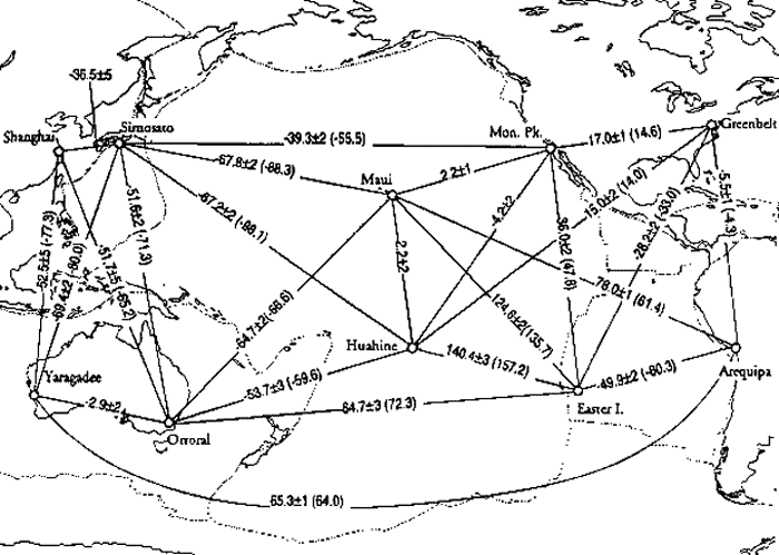
Figure 1.
Selected spherical rates for lines crossing the Pacific Ocean showing average, annual displacement figures in centimetres, obtained from satellite laser ranging (SLR) for the period January 1980 to June 1993. (From Smith et al., 1994)
Recent literature now indicates that there is an increasing awareness of problems confronting conventional static Earth tectonics, to the point were major obstacles to an expanding Earth, as envisaged by McElhinny et al (1978) and Schmidt & Clark (1980), do not necessarily "outnumber the evidence in favour". Of particular interest are the findings of Ahmad (1988a, 1988b) who demonstrated that palaeontological and palaeomagnetic data show unequivocally that India was not involved in long distance drift and collision with the northern continents, as advocated by plate tectonics.
Ahmad (1988a) suggested instead that Pangaea existed as a large, composite super-continent comprising the entire existing continental crust. Palaeomagnetic pole positions indicated to Ahmad that, during the Upper Permian the Earth was 55% to 60% of its present diameter.
Evidence to suggest that Earth expansion may be a viable global tectonic process has been mounting considerably since the 1981 Expanding Earth Symposium, held in Sydney, Australia. The publications of Ahmad (1983, 1988a), Carey (1983a, 1983b, 1983c, 1988, 1995), Ehrensperger (1988), Kremp (1983, 1992), Noëll (1989), Scalera (1990), Shields (1990) and Vogel (1983, 1990) were of particular note, with Vogel's small Earth "terrella" models providing the most convincing quantitative evidence for an expanding Earth. See David Ford's web site "The EXPANDING EARTH" for additional publications by Professor S.W. Carey.
Similarly, at the Smithsonian Institution discussion meeting in July 1989, numerous arguments were presented concerning new concepts in global tectonics (Chatterjee & Hotton, 1992).
These arguments indicated that there seems to be something questionable with the plate tectonic theory as it is currently presented (Kremp, 1992), and that present concepts of plate tectonics - continental drift - polar wandering may need to be re-evaluated, revised, or rejected (Smiley, 1992). In order to satisfy the requirements of the tectonician, Brunnschweiler (1983) recommended that, a working thesis for an expanding Earth must however find the "motor and mechanisms" to move crustal fragments horizontally in order to force them into collisions despite their dispersal by expansion.
Intensive geotectonic research, since the introduction of both the Earth expansion theory and plate tectonics, has now vastly increased the database available for Earth dynamic studies. In particular, with complete coverage of bathymetric contouring and, magnetic, palaeontologic and radiomagnetic age dating of all the major ocean basins, the geological evidence for reconstruction of continents and their displacement histories, according to the ocean-floor magnetic isochron spreading data, is now available to test and explain any geotectonic thesis.
Global Expansion Tectonics is presented here as a unified and revitalized, internally consistent geodynamic thesis of Earth expansion, based on this readily available geological and geophysical database.
The fundamental premises considered in introducing Global Expansion Tectonics involve a number of interdependent and interactive processes namely, that:
generation of post-Early Jurassic oceanic lithosphere along mid-oceanic spreading centres is commensurate with an expansion of the Earth;
mid-oceanic spreading centres are tensional and/or transtensional règimes, with oceanic lithosphere generated in response to a separation of plate margins in sympathy with an expansion of the Earth;
new oceanic lithosphere, generated along mid-oceanic spreading centres, is cumulative with time, with no requirement for removal of older lithosphere by subduction processes;
the total surface area of oceanic lithosphere accumulated in a given time interval is a reflection of the increase in palaeoradius during that time interval, and is therefore a measurable quantity;
basin development and orogenesis are natural consequences of an expanding Earth, as continental and oceanic lithosphere re-equilibrate to a changing surface curvature, and;
hydrospheric and atmospheric accumulation has been increasing with time, in sympathy with an accumulation of the lithosphere.
Empirical Small Earth Modeling: A Brief History
The Earth, like any sphere, does not lend itself to an undistorted representation of its surface area upon a flat map or page of a book. Maps however, are intrinsically necessary for the presentation of Earth based information. Because of this, various mathematical equations have been devised over the years in order to project the image of the surface features of the Earth into map format. The distortions, inherent in all of these cartographic projection techniques are, out of necessity, generally accepted, and acknowledged in the presentation of map based information.
In the presentation of expanding Earth tectonic processes however, as the diameter of the small Earth globe is reduced backwards in time, the distortion of continental outlines becomes increasingly unrealistic and unconvincing in map format as continental areas progressively occupy more of the surface area of the globe. To represent the entire Earth it is therefore necessary to rely heavily on spherical small Earth global models to define accurately the continental configurations, and plate motion history, throughout geological time.
This historical development of small Earth global modeling is briefly summarised from Carey (1975), and Vogel (1983), in order to familiarise the reader with the work of past model makers. The historical development of the theory of Earth expansion has been comprehensively covered by Carey (1975, 1976) and will not be addressed further.
Hilgenberg (1933). Stimulated by the pioneering work of Alfred Wegener on continental drift, Otto Hilgenberg has been attributed as being the first to fit all the land masses together to completely enclose a small papier-machè globe (Kolchanov, 1971; Marvin, 1973; Carey, 1975; Vogel, 1983), (Figure 2).
On his globes all oceans were eliminated and the sialic crust neatly enclosed the whole Earth on a globe about 60% of the diameter of the present Earth.
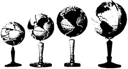
Figure 2
Hilgenberg’s (1933) expanding Earth "terrella" attributed to being the first small Earth models constructed. Small globe is approximately 60% of present Earth radius. (From Vogel, 1983)
Reconstruction across the Atlantic was considered to be convincing however difficulties were encountered in the Indian Ocean, due to a greater dispersion of continents and uncertain initial position of India and Madagascar. The Pacific region was the most difficult to reconstruct, as workers to follow also found. Unlike the Atlantic and Indian Oceans, where the borders retained their shapes, the Pacific borders were considered to have opened much earlier and remained tectonically mobile throughout the dispersal times (Vogel, 1983).
To explain the expansion process Hilgenberg postulated that the mass of the Earth, as well as its volume, waxed with time (Carey, 1975). Because of this stance, and several problems inherent in his reconstruction however, Hilgenberg's ideas on Earth expansion were largely ignored (Marvin, 1973) and he received scant recognition for his efforts.
During the next 30 years the concept of an expanding Earth was advanced by Halm (1935), Keindl (1940), Egyed (1956), Carey (1958), and Heezen (1959), developed primarily in the German and Russian literature.
Brösske (1962): used the present coastlines of the continents and assembled them onto a globe at 55% of the present Earth. His assembly (Figure 3) resembled Hilgenberg (1933) however it had a tighter relationship for Africa, the Americas, Greenland, Europe and Asia. In closing the Pacific Ocean Brösske located eastern Australia into the Peru re-entrant, and the New Guinea front of the Australian plate against California (Vogel, 1983), while the East Indies was packed between the Australian northwest shelf and Southeast Asian mainland (Carey, 1975).
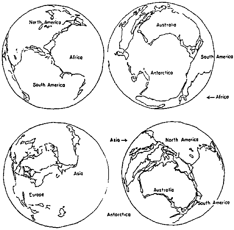
Figure 3
Brösske’s (1962) small Earth reconstruction, at 55% of the present Earth radius, showing a tighter relationship for Africa, the Americas, Greenland, Europe and Asia than Hilgenberg (1933). (From Vogel, 1983)
Barnett (1962, 1969) adopted the 1000 fathom (200 metre) isobath for his reconstruction on a smaller globe as Hilgenberg (1933) had done. He used rubber templates cut from a 4½ inch diameter globe and reconstructed them on a 3 inch diameter wooden globe, representing a palaeoradius of about 65% of the present day Earth (Figure 4).
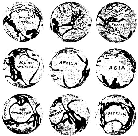
Figure 4
Barnett’s (1962) wooden globe small Earth reconstruction, at approximately 65% of the present Earth radius, showing the suggested pattern of continents soon after continental rifting. (From Barnett, 1962)
Barnett's early reconstructions across the Arcto-Atlantic and Australia to Antarctic were conventional, and the Pacific was closed by bringing West Antarctica against the southern Andes, Eastern Australia against Central America, and the northern margin of Australia against North America (Carey, 1975).
Despite the crude reconstruction method used by Barnett he noted that, "it is difficult to believe that chance alone can explain this fitting together of the continental margins". This, in effect, is the driving force behind advocates of expansion tectonics, the fact that all of the continents can be convincingly reconstructed onto smaller globes.
Barnett later made a new reconstruction (Figure 5) bringing together the southern points of Africa, Australia, South America and the Antarctic peninsular to a common point near the Falkland Islands. He presumed this point to be the site of "primary rupture of the Earth". Carey (1970) similarly considered this point to be the centre of maximum dispersion for all the land-masses of the world.
Barnett's models were the first to emphasise the Earth's hemihedral asymmetry, the antipodal relation of continents and oceans, the greater separation of the southern continents and the northward migration of all continents (Carey, 1975) with respect to the rapidly expanding southern hemisphere.
Figure 5
Detail of Barnett’s (1969) small Earth reconstruction, showing the four southern continents directed towards a postulated site of primary rupture near the Falkland Islands. (From Barnett, 1969)
Barnett also made comment on the newly explored world wide oceanic "rise-ridge systems" (mid oceanic rift zones), suggesting that, in the early phase of the Earth's history, all the tension rifts that gave rise to the oceanic "rise-ridge systems" were mid-oceanic, encircling the continental plates.
Creer (1965) carried out model experiments by enlarging fibreglass shell models of continents by a factor of 1.82 and assembling them onto a 50 centimetre globe, corresponding to a radius change of 55% of the present size Earth. The impression Creer received was that, "the fit of the continents on a smaller Earth appeared to be too good to be due to coincidence and required explaining".
The fits obtained at 0.55, 0.77 and 1.0 of the present radius are shown in Figures 6.
Figure 6
Creer’s (1965) small Earth reconstruction, at 55% of the present Earth radius, suggesting to Creer that the continental lithosphere first developed a U-shaped crack between Australia, America and Asia, which subsequently widened to form the Pacific Ocean. (From Vogel, 1983)
According to Creer the continental crust first developed a U-shaped crack between Australia, America and Asia during the "Early Precambrian". Subsequent Earth expansion was then largely taken up along this initial crack, which widened to form the Pacific Basin. His Atlantic assembly was similar to present day conventional reconstructions, however difficulties were still raised with the Indian Ocean. Creer included a Tethys which suffered an unconvincing discontinuity of more than 6000 kilometres from Saigon to its New Guinea continuation on the site of the Aleutians (Vogel, 1983).
In contrast to other workers Creer envisaged that expansion occurred early in the Precambrian. Being strongly influenced by the emerging conclusions of palaeomagneticians he concluded that the Earth's radius was not appreciably different from its present value when the fragmentation of Laurasia and Gondwanaland commenced during the Permian or Triassic.
Vogel (1983, 1984, 1990): to date has produced the most comprehensive set of models, or "terrella" as he referred to them, at diameters of 40%, 60%, 66% and 75% of the present sized Earth (Figures 7) plus a unique representation of a 55% reassembled globe inside a transparent plastic sphere of the present diameter.
Vogel's models again confirmed the greater dispersion of the southern continents, and he noted also a marked westward movement of all the northern continents relative to the southern continents, along what is now referred to as the "Tethyan shear", described by Carey (1976). These models, based on mid-oceanic ridge systems and sea floor spreading zones, demonstrated to Vogel that, in general, the continents tended to move out radially from their Precambrian positions to reach their modern positions.
Vogel commented that this is an "odd coincidence for any theory except that of expansion of the Earth".
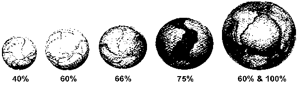
Figure 7
Vogel’s (1983) "terrella" models at various stages of expansion commencing with a continental reconstruction, without continental shelves, at 40% of the present Earth radius. A 60% radius model is shown within a transparent sphere of the present day Earth at the right, demonstrating a "radial" motion of Earth expansion. (Modified from Kremp, 1992)
From his extensive modeling Vogel (1990) gave a comprehensive outline of the fit of continental fragments under the headings of Gondwanaland and Laurasia. Development of the oceans, with increasing Earth radius, was considered to have commenced during the Mesozoic, after final dislocation of the continental fragments, due to widening of the main mid-oceanic fracture zones. Vogel went on to consider the two hemispheres as complementary counterparts, with no Tethys Ocean or other "sphenochasms" required.
Vogel concluded from his modeling that: at a reduced Earth radius of 55% to 60% of the present,
the continental outlines can be fitted together to form a closed crust;
the positions of the different continents with respect to each other remain generally constant, with their separation caused by a "radial expansion of the Earth" and;
the cause of the movements of continents resulted from an accelerating increase in radius with time, in accordance with sea-floor spreading.
Vogel commented that "an accordance of these three phenomena cannot be accidental", but due to "processes operating from within the interior of the Earth resulting in Earth expansion".
In addition to the spherical models presented above a number of authors have presented graphical models worthy of note, based on various modeling techniques.
Dearnley (1965a, 1965b) used a reconstruction of Precambrian orogenic belts in the Superior and Grenville règimes to deduce an expanding Earth model and proposed that the Earth's radius was 4400 kilometres (69%) at 2,750 million years, and 6000 kilometres (94%) at 650 million years (Figure 8).
Dearnley regarded the major crustal features, in particular the orogenic fold-belts, as a direct crustal response to the underlying convection current activity of the mantle, and suggested a relatively steady rate of expansion commencing as far back as 4500 million years ago.
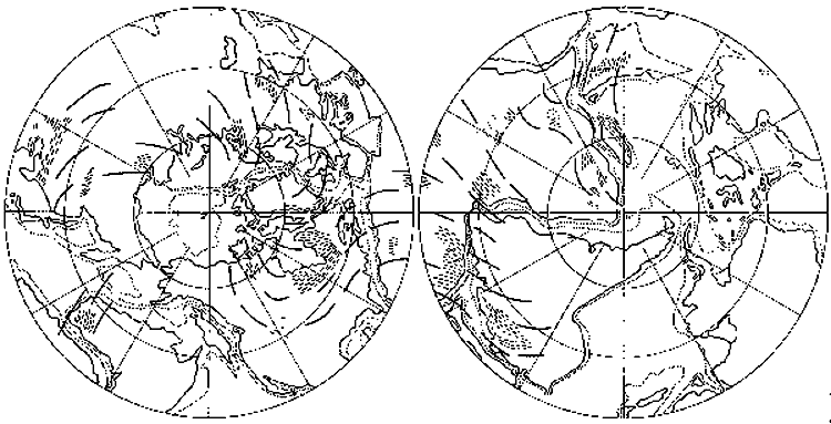
Figure 8
Dearnley’s (1965a) small Earth reconstruction at a palaeoradius of 4400 kilometers, determined from a reconstruction of the Superior and Grenville régime Precambrian fold belts. Dashed and heavy lines represent fold-belts and trend lines respectively. (From Dearnley, 1965a)
Shields (1976, 1979, 1983b, 1990) based his model compilation primarily on palaeobiology, especially the trans-Pacific terrestrial biotic links that are not reflected in regions bordering the Atlantic. Shields (1979) used these biotic links to emphasis an east-west initial opening of the Pacific Ocean during Early Jurassic times, contrary to the plate tectonic view that the Pacific was formed from an even wider ocean ("Panthallassa Ocean", Scotese (1987)) during Mesozoic times.
Shields (1979) presented a new reconstruction of the continents bordering the Pacific (Figure 9), a new Arctic Ocean reconstruction, and a more or less conventional Atlantic and Indian Ocean assembly.
He concluded that "the Tethys Sea was much narrower than many suppose".
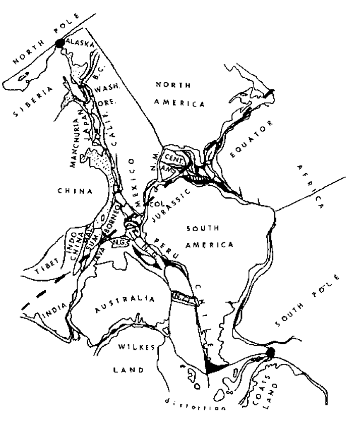
Figure 9
Shields’ (1976) small Earth reconstruction of continents bordering the Pacific Ocean, based trans-Pacific terrestrial biotic links. (From Sheilds, 1976)
Owen (1976, 1983a, 1983b) produced a voluminous atlas of continental displacement and expansion of the Earth during the Mesozoic and Cenozoic, based on a linear global expansion rate, commensurate with a 20% increase in diameter to the present mean Earth diameter, since the Late Triassic-Early Jurassic.
Owen (1976) adopted the 1000 metre isobath as the edge of the continental shelf and used base maps of the continents, cut from 2 millimetre thick expanded polystyrene foam, in conjunction with rubber inflatable spheres, to determine the point at which the various continents fitted together to reform Pangaea precisely. Using this method the diameter of the Earth in the Late Triassic-Early Jurassic was found to be approximately 80% of its modern mean diameter (Figure 10). The rate of Earth expansion was determined to be essentially linear for the past 200 million years.
Although Owen (1976) concluded that reconstructions which assume a constant dimension Earth are untenable, he assumed that marginal subduction zones were active throughout the Mesozoic and Cenozoic, which is in direct contradiction to the Earth expansion views of Carey and Vogel.
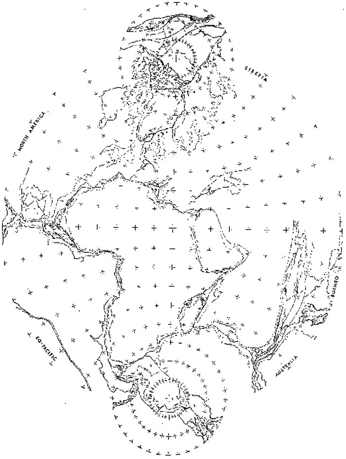
Figure 10
Owen’s (1976) small Earth reconstruction of the Pangaean hemisphere at 80% of the present Earth radius, with positions of the continental lithosphere determined by their modern 1000 meter isobath. Trizenithal projection centered on the north and south geographic poles, constructed at 180 Ma. (From Owen, 1976)
Schmidt and Embleton (1981) in commenting on the Early Proterozoic common apparent polar-wander paths for Africa, Australia, Greenland and North America deduced that there is abundant geochemical, geological, geochronological and tectonic evidence to suggest that these landmasses were much less dispersed in the Precambrian than they are now.
They used a small Earth globe, equal to 55% of the present diameter, to demonstrate that the Proterozoic geological, geochronological and palaeomagnetic information can be satisfactorily resolved on a smaller Earth diameter.
Because of the palaeomagnetic evidence against Earth expansion however (eg. Egyed, 1960, 1961; Cox & Doell, 1961a, 1961b; Ward, 1963, 1966; van Hilten, 1963, 1968; van Andel & Hospers, 1968a, 1968b; McElhinny & Brock, 1975) they proposed that the paradox may be resolved by an expansion of the Earth occurring during the Proterozoic, between about 1600 to 1000 million years ago (Figure 11).
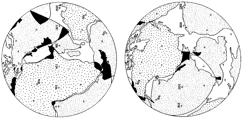
Figure 11
Schmidt & Embleton’s (1981) small Earth reconstruction, based on Early Proterozoic common apparent polar-wander paths, at 55% of the present Earth radius. (From Schmidt & Embleton, 1981)
Neiman (1984, 1990) based his small Earth modeling on a tectonic development of the Earth, and considered the process of stretching and rupture of the core to be characteristic of the growth of continental zones.
The most rapid changes were found to have occurred during the Mesozoic and Cenozoic. Continental regions were considered to be manifested in the formation of "whole systems of aulacogens", particularly around continental margins, and oceanic zones developed initially as comparatively small and shallow epicontinental seas.
Neiman considered that the change in size of the Earth varied from 16% of the modern radius at 2.2 billion years, 30% at 1.2 billion years, 37% at 1 billion years and 55% to 60% for the Mesozoic (Figure 12).
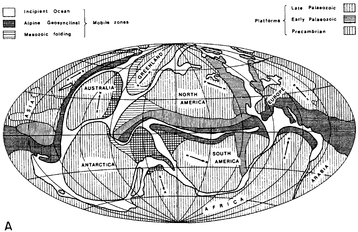
Figure 12
Neiman’s (1984) schematic small Earth tectonic reconstruction of the Earth for
(A) the Mid-Cenozoic and,
(B) the Late Proterozoic.
Arrows indicate the present-day north orientation for each continent. (From Neiman, 1984)
Perry (in Carey, 1986) demonstrated with geometrical precision what Vogel (1983) found from empirical small Earth modeling. He set up a computer programme based on matrix algebra and a hidden-line algorithm, so that continents could be moved radially from the centre of the Earth and translated using one centre of coincidence and one rotation pole (Figure 13).
Perry was able to generate successive positions of spreading ridge, fracture zones, and magnetic anomaly lineations, and from these he was able to calculate the amount of radial expansion implied by each anomaly.
Figure 13
Perry’s computer reconstruction of the Earth, suggesting that continents move out "radially" during Earth expansion, using one centre of coincidence and one rotation pole (From Carey, 1986)
Scalera (1988) used computerized cartographic methodology in an attempt to resolve the most fundamental problem confronting Earth expansion tectonics; that of spherical geometry varying with time. Based on tectonic lineament and geological-match data, Scalera constructed computer generated orthographic projections of smaller radius Earth models at radii of 5300 kilometers (83%), 4300 kilometers (67%) and 3500 kilometers (55%) (Figure 14).
From the results of his research Scalera formed the opinion that "the Earth's history, as written and clearly readable on the bottom of the oceans, is not the history of plate tectonics but the history of a planet that has expanded".
Figure 14
Scalera’s (1988) computerized cartographic small Earth reconstruction, based on tectonic lineament and geological match-data. (From Scalera, 1988).
Preliminary Discussion
From this brief review of small Earth expansion models it must be noted that, although there is extensive literature on the subject of Earth expansion, these published models represent essentially the sum-total from which Earth expansion has been judged in the past. These models were developed, and the majority conceived, prior to or during the early stages of investigation into sea-floor spreading, prior to a complete and accurate geological and geochronological coverage of the ocean basins, and prior to the inception of modern global tectonic concepts.
These reconstructions of continents on small Earth models outlined above all suffer from a lack of precise cartographic methods, and quantitative constraint of both palaeoradius and time. Only Owen used a careful, quantitative, non-computerised cartographic method to generate his models, however, even Owen's method predates modern oceanic mapping which, if available, would have permitted him to possibly explore much smaller Earth radii.
Throughout the subsequent, and even most recent literature, small Earth models, and hence Earth expansion, continue to be judged by the scientific community as speculative and inconclusive. It is considered that one of the the main reasons for this misguided judgement is because, with reconstructions based primarily on a visual fit-together of opposing continental margins, the small Earth models give rise to a wide variation of morphological fits, in particular the Pacific Ocean region. Similarly a conclusive, quantifiable "motor and mechanism" for Earth expansion was not given to enable researchers to judge conclusively the merits of Earth expansion.
The small Earth models outlined above all indicate however that, a Pangaean reconstruction on a globe representing between 55% to 60% of the present Earth radius can produce a tight, coherent fit of continents. Depending on the isobath or continental outline chosen; orogenic zones match consistently; geological boundaries are maintained; and palaeobiological boundaries match across continental boundaries. Regardless of the limitations of these historical small Earth models this fact cannot be ignored. With the completion of modern bathymetric and oceanic magnetic isochron mapping, the technology and global database is now such that the problem of constraining both palaeoradius and plate configuration with time can now be addressed and accurately quantified.
This published oceanic database will now be used to quantify the introduction of Global Expansion Tectonics as a viable alternative global tectonic concept.