|
http://web.archive.org/web/20050325110042/http://www.geocities.com/CapeCanaveral/Launchpad/6520/#Download
Global Expansion Tectonics
Exponential Earth Expansion
from the Pre-Jurassic to the Present
by James Maxlow
Global
Expansion Tectonics
Global Expansion Tectonics is presented as a revitalized thesis of
Earth expansion which utilizes published oceanic magnetic isochron
and continental geological and geophysical data (e.g. Larson et al,
1985; CGMW & UNESCO, 1990) to empirically constrain both
palaeoradius and plate reconstruction from the Archaean to the
Present. Global Expansion Tectonics is quantifiable both empirically
and mathematically by assuming that the Earth's lithospheric budget;
in particular the increase in ocean sea floor surface area at the
mid-ocean-rift zones, has been cumulative with time, and the surface
area of oceanic lithosphere has been fully fixed in the rock record.

A mathematical relationship for the rate
of change of palaeoradius with time was determined by considering
the exponential increase in cumulative surface area, from the
Archaean to the Present, of both oceanic and continental
lithosphere. By using the method of least squares to calculate
gradients of curves of best fit, an equation for rate of Earth
expansion was then established, and applied to a study of the
kinematics of Earth expansion.
In the concept of Global Expansion Tectonics, prior to the Early
Jurassic, modern deep ocean basins did not exist. All continental
lithosphere was united to form a single Pangaean super continent
enclosing the Earth at a much-reduced palaeoradius, with the volume
of hydrosphere and atmosphere increasing with time in sympathy with
the volume of oceanic lithosphere. This increase in hydrosphere and
atmosphere is considered to have resulted from mantle
devolitilisation, as a natural response to a decrease in surface
gravity and mantle temperature and pressure conditions with time.
Oceanic areas during the pre-Jurassic were considered to be
represented by shallow, intra or epi-continental seas, with
deposition of sediments within deeper "geosynclinal" sedimentary
basins masking all evidence of sea floor spreading.
Pre-Jurassic small Earth models for the Palaeozoic and
Neoproterozoic indicate that the primordial Archaean Earth ("Primordia")
was approximately 1700 kilometres radius, and remained relatively
static throughout the Archaean to late Mesoproterozoic. This accords
well with published literature which suggests that there is no
evidence for Earth expansion prior to the Mesoproterozoic, and the
scarcity of evidence for horizontal crustal movements places
constraints on the extent of expansion prior to the upper
Proterozoic. The dominance of tensional tectonics during the
Archaean and Proterozoic however, suggests also that some degree of
expansion may have occurred by crustal dilation associated with
faulting and rifting.
So
What's New?
Oceanic magnetic isochron data (CGMW & UNESCO, 1990) was utilised
during early research into Global Expansion Tectonics to empirically
constrain both plate configuration and palaeoradius at a
much-reduced Earth radius. The small Earth models constructed during
this research demonstrated unequivocally that, if the Earth has
expanded since at least the Early Jurassic then, small Earth
reconstructions coincide fully with the spreading and geological
crustal data, and requires explaining. Something which, globally,
plate tectonic reconstructions still cannot get right.
In constructing the small Earth models displayed within the Global
Expansion Tectonics document it was argued that, in order to
quantify any variation in the Earth's palaeoradius, and constrain
plate configuration with time, it is necessary to take into account
the area and pattern of oceanic lithosphere. By moving backwards in
time from the present, successively older chron intervals from
across active spreading ridges must be removed, and each of the
remaining chron intervals reunited along their common spreading
ridges. The series of small Earth models shown in the figure below
were constructed by simply subtracting the next youngest chron
interval from the previous model, and refitting the plates together
at a reduced Earth radius.


The small Earth models shown in the
figure demonstrate that, if the Earth has expanded, small Earth
reconstructions coincide fully with the sea floor spreading and
continental data. These small Earth models consistently demonstrate
a greater than 99% fit-together of all plates, for each chron
interval shown, and suggests that the surface area of oceanic
lithosphere measured for each chron interval represents the total
area of new oceanic crust, generated and preserved during the
interval of time under study. Thus empirically negating the need for
removal of excess lithosphere by subduction processes. These models
are now on permanent display at the Geological Museum of the Polish
Geological Institute, Warsaw.
Most
Frequently Asked Objections
Acceptance of the theory of Earth expansion is currently envisaged
by researchers to be thwarted by major obstacles which supposedly
"outnumber the evidence in favour". The most commonly perceived
problems include an explanation for the existence of the two very
different extensional structures exposed on the oceanic floors: the
mid-oceanic ridges and the trench-arc/back-arc zones, characterized
by very different seismicity and volcanism; the problem of
atmospheric and hydrospheric accumulation on an expanding Earth; and
the adaptation of palaeomagnetics to a constantly variable Earth
radius. Frequently asked objections to Earth expansion include:
What
about the Pre-Jurassic?
In Global Expansion Tectonics, prior to the Early Jurassic, modern
deep ocean basins did not exist. All continental lithosphere was
united to form a single Pangaean supercontinent enclosing the Earth
at a much-reduced palaeoradius. Oceanic areas during the
pre-Jurassic were represented by shallow, intra- or epi-continental
seas with deposition of sediments within deeper "geosynclinal"
sedimentary basins masking all evidence of sea floor spreading. The
Global Expansion Tectonic Precambrian Earth expansion process, shown
below, is considered to have been very much subdued, prior to
development of intra or epi-continental Palaeozoic "geosynclinal"
sedimentary basins, leading to post- Mesozoic crustal breakup and
continental dispersal.
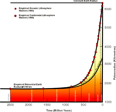
Empirical small Earth models for the
Palaeozoic and Neoproterozoic indicate that the primordial Earth
size for the Archaean was approximately 1700 kilometres radius and
remained relatively static throughout the Archaean to late
Mesoproterozoic. If you have trouble with this statement remember
that, at approximately 15 to 20 billion years, i.e. between six and
eight figure widths to the left, the entire Universe was supposedly
a singularity (zero) prior to the "Big Bang". The increase in
palaeoradius during the Archaean to late Mesoproterozoic was
approximately 60 kilometres.
This accords well with published
literature which suggests that there is no evidence for Earth
expansion prior to the Mesoproterozoic, and the scarcity of evidence
for horizontal crustal movements places constraints on the extent of
expansion prior to the upper Proterozoic. The dominance of tensional
tectonics during the Archaean and Proterozoic however suggests also
that some degree of expansion may have occurred by crustal dilation
associated with faulting and rifting.
Where
does the additional mass come from?
This is a very difficult question to answer. Because, in the past,
the Earth has always been considered static in size it has not been
necessary to ask the question. From the mathematical relationship
established for the rate of change of palaeoradius from the Archaean
to the Present it was calculated that the Earth is undergoing an
exponential expansion at the present rate of 21 mm/year, commencing
from an Archaean primordial Earth size of approximately 1700
kilometres radius. Where the additional mass comes from is therefore
a valid question.
Researchers elsewhere consider that the
Earth is expanding because of an exponential increase in mass with
time, e.g. matter is the antithesis of energy, however the
kinematics of an exponentially expanding Earth suggests that mass
may possibly have been constant with time resulting in a reduction
in density and surface gravity. The ultimate cause of Earth
expansion must however be considered intimately related to a
cosmological expansion of the Universe, i.e. where does the mass of
the Universe come from?
What
about the ocean water and atmosphere?
Researchers have argued that, for a pre-Jurassic small Earth with a
continuous continental crust, a large expansion process implies that
the entire Earth would have been covered by an ocean with an average
depth of 6.3 kilometres. Global Expansion Tectonics however
considers that during Earth expansion, the whole column of
atmosphere, hydrosphere, oceanic lithosphere and underlying mantle
has been added at an accelerating rate through geological time,
accreted primarily at the growing ridges and rift zones.
As the ocean waters and ocean floors
both have the same origin it is to be expected that they would be
produced pari passu, with the generation of ocean water and
atmosphere keeping pace with the growth of oceanic lithosphere. This
increase in hydrosphere and atmosphere is considered to have
resulted from mantle devolitilisation, as a natural response to a
decrease in surface gravity and mantle temperature and pressure
conditions with time. This devolitilisation process may also
represent a prime mechanism for mineralisation.
What
about orogenesis?
Brunnschweiler, in a paper dealing with the evolution of geotectonic
concepts in the past century, considered that Earth expansion was
essentially a radial movement and therefore its tangential plate
displacements are only apparent, not real. The possibility of
orogenesis developing under these conditions of radial expansion was
discounted because the necessary vertical movements did not appear
to explain the observed compressional features. It is unfortunate
that this "radial expansion" concept has crept into the published
literature. As Carey first recognized, the present Earth has a
hemihedral asymmetry, with an antipodal distribution of continents
and oceans. What this implies is that the southern continents have
separated much greater distances than those of the northern
hemisphere, with a much greater insertion of new oceanic lithosphere
in the southern hemisphere.
Small Earth modeling confirms that the
Earth expansion process is asymmetric, not radial, and therefore
plate motion is made up of both tangential and radial vector
components. Within Global Expansion Tectonics, orogenesis is
considered intimately related to an asymmetric expansion of the
Earth, resulting from intra-cratonic interaction during gravity
induced relief of surface curvature. The radial and tangential
vector components of this asymmetric expansion process giving rise
to the required continuum of orogenic models, varying from
compressional to translational and torsional.
What
about subduction?
The apparent overriding of the north Pacific Ocean plate by North
America and Australia is often quoted as a classic example of plate
consumption by subduction. In all conventional Late Triassic to
Mid-Jurassic reconstructions of Pangaea, on constant radius Earth
models, the area of the Pacific Ocean is increased essentially by
the sum of the areas of the Atlantic and Indian Oceans, less that of
the "Tethyan" and "Palaearctic" Oceans. This early Mesozoic "Panthallassa"
Ocean would have possessed an oceanic crust generated during the
Triassic and Palaeozoic at least. The Mesozoic and Cenozoic history
would therefore be one of east-west and north-south contraction of
the oceanic area to the size of the modern Pacific Ocean, subduction
of all pre-Mesozoic crust, and subduction of a substantial quantity
of oceanic crust generated during the Mesozoic to Cenozoic.
Global Expansion Tectonics suggests
however that, when the circum-Pacific continents are reassembled
onto small Earth models, the necessity for such an expansive
pre-Mesozoic "Panthallassan Ocean", and similarly a "Tethyan Ocean",
disappears. Subduction of between 5,000 to 15,000 kilometres of
Pacific oceanic lithosphere therefore becomes unnecessary. Instead,
by consideration of the spherical spatial and temporal plate motion
history of the Earth as a whole, this north Pacific Ocean region is
interpreted as a region of Mesozoic asymmetric spreading history
evolving towards Cenozoic symmetric type spreading. A value of 21
mm/yr, calculated for secular increase in Earth radius, is
considered adequate to account for all of the ocean floor growth
since at least the Early Jurassic, without the need for
consideration of subduction of oceanic lithosphere.
What
about palaeomagnetics?
Palaeomagnetics has long been considered the cornerstone of plate
tectonics. Fundamental premises regarding the constancy of
continental surface area, used to determine palaeoradius, however
stem from the early 1960s, prior to the development of modern global
tectonic concepts, or completion of the oceanic crustal database.
Mathematical equations were developed by palaeomagneticians from
conclusions insisting that continental surface areas have remained
essentially constant, hence any variation in palaeoradius was
concluded to have been negligible with time.
Since these equations were first
derived, modern plate tectonic concepts have demonstrated that the
Earth's crust is not a passive adjunct of lithospheric plates, but a
dynamic, interactive layer of the Earth. Modified palaeomagnetic
equations developed for Global Expansion Tectonics prompts a need
for a more thorough overhaul of the concepts of palaeomagnetics, in
particular the conclusions drawn from the interpretations of pole
positions, apparent polar wander paths, and displaced terranes.
Concluding Remarks
By considering the published Post-Jurassic oceanic magnetic isochron
data of CGMW & UNESCO (1990), to constrain both plate configuration
and palaeoradius with time, it was concluded that Global Expansion
Tectonics provides a quantifiable "motor and mechanism" for Earth
expansion. This has enabled the dynamic principles behind all major
geologic phenomena to be resolved and readily explained. The success
of this early research demonstrated an urgent need to extend
modeling to the Precambrian, [currently in progress] and make this
information available to industry. It was considered however that,
because of the predictable hostility towards change, research should
be structured towards demonstrating definitive auguments using
modern, readily available, empirical data.
It is considered that an expanding Earth model will enable
specialist researchers in fields such as palaeontology,
palaeogeography, metallogeny, palaeomagnetics and so on to spatially
display their global data on a worldwide, or continental scale as
required. It is anticipated that all the specialist fields of
geology can be confidently related spatially and temporally to a
predictable process of Archaean crustal formation, Proterozoic
crustal fragmentation, Proterozoic to Palaeozoic basin development,
and Post-Jurassic plate motion history.
It is also considered, for geoscientific research to continue into
the 21st Century, that we must be prepared to remove the "blinkers
of dogma", so prevalent in our learned institutions, in order to
encourage active research into alternatives too accepted geoscience.
|