|
The Planetary Grid - A New Synthesis by William Becker and Beth Hagens
Introduction
Yet the events continue
to be catalogued, with many reports suppressed or labelled "fraud"
by orthodox scientists. Worldwide networks of questioning theorists
persist and grow with each report. We will try to mention as many of
our correspondents as we can within the text of this article.
Several contributors, listed at the end. have truly transformed our
view of this work.
What may make the proposition even more fascinating is the parallel analogy that — just as the driving force behind the creative energies of the Renaissance was the rediscovery of Greco-Roman science/philosophy; so with our planetary grid theorists, the driving force behind most research efforts is the continuing flow of evidence, both physical and metaphysical, that the existence of Pre-Egyptian civilizations — some with highly advanced technologies — is now no longer speculative, but a necessary assumption for developing any comprehensive archaeological treatise.'
We believe that the planetary grid is an ancient model that brings control through comprehensive understanding and not through detached myopic analysis/manipulation. The contemporary video artist/philosopher Dan Winter expresses the idea beautifully.
Illustration #1 These stones on display at the Ashmolean Museum in Oxford, England suggest a life of creative intellectual synthesis for the Neolithic craftsmen
who crafted and "wrapped" them with leather thongs.
Planetary Grid Researchers: Prehistoric to Present
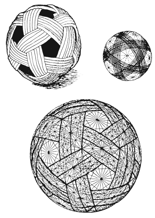
The oldest evidence of possible planetary grid research rests within the Ashmolean Museum of Oxford, England. On exhibit are several hand-sized stones of such true geometric proportion and precise carving that they startle the casual viewer. Keith Critchlow, in his book Time Stands Still, gives convincing evidence linking these leather-thonged stone models (see illustration #1) to the Neolithic peoples of Britain — with a conservative date of construction at least 1000 years (ca. 1400 B.C.) before Plato described his five Platonic solids in the Timaeus.
And yet, here they are — the octahedron, icosahedron, dodecahedron, tetrahedron, and cube all arrayed for comparison and analysis. Other multi-disciplined archaeological researchers like Jeffrey Goodman3 and A.M. Davie4 have dated the stone polyhedra to as early as 20,000 B.C. and believe they were used as projectiles or "bolas" in hunting and warfare. Davie has seen similar stones in northern Scotland which he attributes to the early art of "finishing the form" of crystalline volcanic rocks which exhibit natural geometry. He dates these artifacts to at least 12,000 years before Plato (ca. 12,400 B.C.). Critchlow writes, "What we have are objects cleany indicative of a degree of mathematical ability so far denied to Neolithic man by any archaeologist or mathematical historian."
In reference to the stones' possible use in designing Neolithic Britain's great stone circles he says, "The study of the heavens is, after all, a spherical activity, needing an understanding of spherical coordinates. If the Neolithic inhabitants of Scotland had constructed Maes Howe (stone circle) before the pyramids were built by ancient Egyptians, why could they not be studying the laws of three-dimensional coordinates? Is it not more than a coincidence that Plato as well as Ptolemy, Kepler, and Al-Kindi attributed cosmic significance to these figures." Yet another historian, Lucie Lamy, in her new book on the Egyptian system of measure gives proof of the knowledge of these basic geometric solids as early as the Egyptian Old Kingdom, 2500 B.C.
We agree, in general, with all the above researchers that the crafting of sophisticated three-dimensional geometries was well within the capabilities of Pre-Egyptian civilizations. With the concept that knowledge of these geometries was necessary to the building of stone circles and astronomical "henges" — we also agree — and would add that we have evidence that suggests that these hand-held stones were ' 'planning models,'' not only for charting the heavens and building calendrical monuments, but were also used for meteorological study; to develop and refine terrestrial maps for predicting major ley lines of telluric energy; and, in conjunction with stone circles, were used to construct charts and maps for worldwide travel long before the appearance of the pyramids.
Take another look at the five Neolithic stones. Notice the placement of points on not only completed intersections where hongs connect — but on the ' 'open comers'' where thongs might be added. The central figure, the dodecahedron, has all twelve centers of its pentagonal faces marked with points for further 'wrapping" — as with the cube figure to the far right. Its corners are defined similarly by marked open points. Now note the tetrahedron, the second figure from the right Its four vertexes or corners, which traditionally define four triangles, have already been bisected by a second array of thongs defining another tetrahedron overlapping the first at midpoints. It is our contention that these stones were not wrapped and marked with leather to facilitate their use as "bolas" or projectiles. The stones and their varied nets are too delicate and complex to have been used as hunting and warfare shot.
Their appearance struck us initially as ritual objects similar to the decorative reed spheres found in Southeast Asia; or as religious symbols such as the mysterious bronze and gold spheres found in France and Vietnam — which some say depict the ancient text of the Tao Teh Ching. It may well be that all of these hand-held objects served similar planning and mnemonic functions for the people who treasured and crafted them. (See illustration #2)
Illustration #2
Viewing the stone polyhedra together, we can only conclude as Keith
Critchlow does — that their intended use was for the study,
comparison, and analysis of spherically determined systems of
geometry. Given the apparent use of these stones as "planning
models," and given the apparent "extra wrap" of thongs on the
tetrahedron — consider the result if the Neolithic craftsman of
these forms had decided to discover the ultimate in delineated
spherical geometry models, a single sphere upon which would be
combined all the wrappings and points of all five solids.
Illustration #3 this beautiful polyhedron — which requires the overlap of a dodec and icosahedron. Fifteen "great circles" or "equators" of leather thong create the 120 Polyhedron.
Illustration #4 These were of such importance that archaeologists have cast concrete replicas for their restorations at Knossos.
Notches in the top of the stand have led some
to suggest that these might have been some sort of spit
barbeque device. Returning to the creation of our ultimate spherical model, the second step would be to take the other figures — cube, tetrahedron, and octahedron — and lay out their line arrays over the existing 62 point pattern. You will find that not only is the 62 point system of vertexes compatible with the icosahedron and dodecahedron — but that all the leather thong patterns ot all the polyhedral stones are precisely "mappable" over those same 62 vertexes. In fact, our surprised craftsman would soon discover that all five stone arrays can be overlapped one upon the other with different comer matchings until a beautiful polyhedron with 121 "great circles" and 4,862 points has been developed. This is the ultimate single sphere pattern which houses all five Platonic solids within multiple orientations (see illustration #5).
illustration #5
This is the same form that was used by R.
Buckminster Fuller for his domes and in our research, we have called
it the Unified Vector Geometry (UVG) 120 Sphere. We consider it the
key component in our proposed "new synthesis" of planetary grid
research.
Illustration #6
depicts the elegant theory of
mathematics embodied in the planning of the city of Cairo. Benson's work may well provide a helpful, radically new framework for historical linguistics as well as uncover a lost simplicity in the art and numbers of geometry.
We suggest that Plato's most noble framework for building the
universe is a form which unifies and supports all the forces
operating simultaneously within the five
regular solids, the four primary elements, and the earth (Gaia)
itself — the Unified Vector Geometry 120 Sphere. We further contend
that this sphere is the pattern upon which the ancients built their
armillary spheres, which to this day are used to cast shadows for
reading the solstices and equinoxes.
A related set of angles in the
Megalithic landscape, 23 1/2 and 47 degrees, is equally regular but
does appear to relate to celestial phenomena of the common variety.
In many cases, these and the other angles link one sacred site to
another miles distant. The basic triangle in our Unified Vector
Geometry (UVG) 120 Sphere exhibits just these angles, at intervals
strangely correspondent with those found by Lockyer, and Cyr and
others.
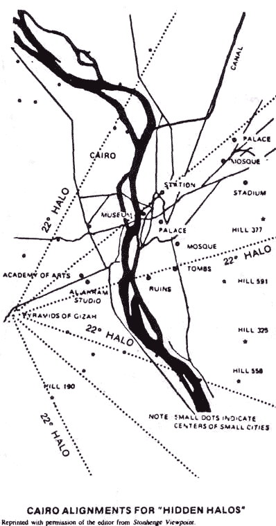
Illustration #7
Donald Cyr is encouraging the use of a simple Halo
Sighting Template to be superimposed on maps of ancient sites in
order to detect alignments that may indicate "hidden halos" —
atmospheric events that were almost certainly a part of the daily
life of Megalithic man. This sort of research will require the
cooperation of compartmentalized scientists in astronomy, geology,
archaeology, and other disciplines — but may recreate a holistic
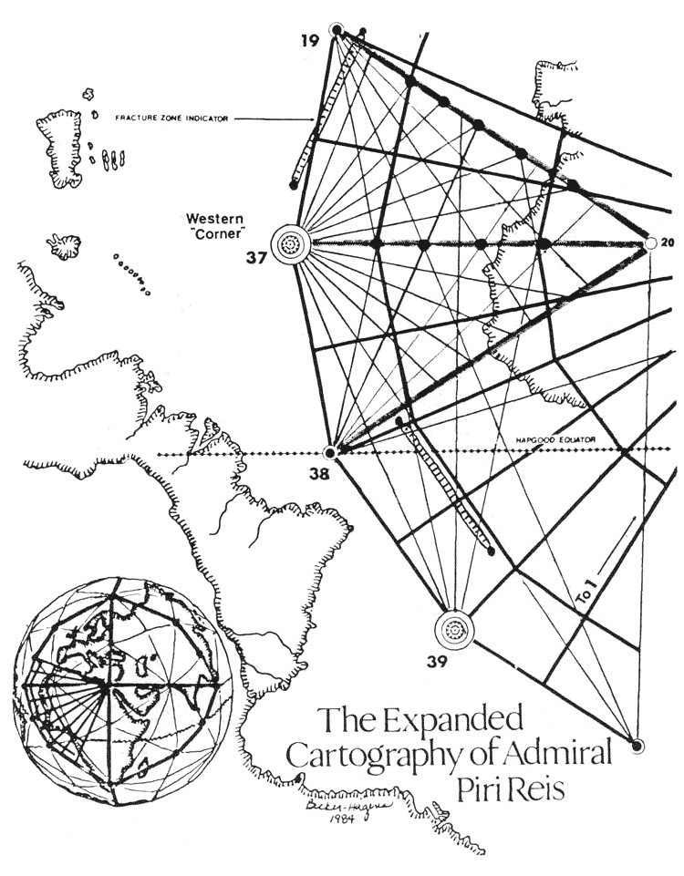
approach to Gaia that supported the lifestyle of the ancients. The U.S. Navy has analyzed the Pin Reis map and determined that it is a correct circular grid projection from Cairo. The half diamond (outlined by grid points 37, 19, 20 and 38) which contains the complete construction infill of the original map shows a superficial, though perhaps indicative, resemblance to two Basic Triangles of the UVG system we propose.
Could Plato have avoided in the Timaeus a direct reference 10 the
simple dodecahedron as his framework for universal crea
Could this map have been an extension of the site
lines and solstice/sunrise markers which encircle ancient Cairo?
Viewed "from above," the major points on the Piri Reis map so nearly
approximate points on our UVG 120 Sphere that we have included a
sketch using our geometry and Piri Reis' lines which attempts to
complete the missing portion of the world map the Admiral
originally drew.
Illustration #9 The Buache Map of 1737 shows Antarctica correctly without its ice cover and may indicate everything from a dramatically different earth climate than today to a technical capacity beyond that generally attributed to human culture 10,000 years ago. The map provides an interesting piece in grid theory:
the
centers of all UVG 10/12 Pentagons fall at the edges of continents
or in oceans.
The Piri Reis map was found in Istanbul in 1929
and is said to have been copied from a map originating in the
library in ancient Alexandria. The Buache map of 1737 is said also
to be the result of copying ancient Greek maps. Both maps
astonishingly depict Antarctica's true land masses through their icy
cover — though instruments to detect such land masses were not
invented until 1958. Even if the maps are complete frauds, they
still predict Antarctica's true profile thirty years early.
Notice the remarkable patterns
of mountain ridges running 270 around Hawaii; the flat "plain" to
the northeast; the boundary through the western quarter of the
United States and Canada which marks the division between the
Pacific plate and the North American shield. Whether or not these
continents existed is a less important question than how accurately
the maps mesh with the best contemporary scientific knowledge. The
correspondence is very close.
Ivan Sanderson, researcher into the unexplained, asked such questions in the 1960s and 70s — and with several associates, he set out to "pattern the mysteries" by taking full advantage of modern communication technology and statistical data analysis. His success was startling.
His 1972 article in Saga magazine, "The Twelve Devil's Graveyards Around the World," plotted ship and plane disappearances worldwide, focusing attention on 12 areas, equally spaced over the globe, in which magnetic anomalies and other energy aberrations were linked to a full spectrum of strange physical phenomena (see illustration #11).
Illustration #11 . Highest on Sanderson's statistical priority list was a lozengeshaped area east of Miami, in the Bahamas, on the western tip of the infamous Bermuda Triangle. This area's "high profile" of strange events, Sanderson concluded, was mostly due to the enormous flow of air/sea traffic in the area. Other zones of anomaly, though less familiar, were equally rich in disappearances and space-time shift occurrences.
A pilot flying with passengers near the Hawaii zone
suddenly found himself in a "dead zone" without instruments and
unable to communicate beyond the cockpit. After flying some 350
miles, the "phenomenon" lifted and the pilot found that tower
officials could find no measurable time had elapsed between the
beginning of his "dead zone" experience and its end.
These same areas, in the pattern of an icosahedron, have been mapped out in the Keys of Enoch (1977) by J. J. Hurtak but are explained as natural time-warp contact areas used by the Brotherhood. It is not unreasonable metaphysical theory to assume a pulse to the universe, an electromagnetic heartbeat which makes time appear to go backward and ahead — for planes of existence to manifest and disappear. What better spots for contact than Sanderson's? (See illustration #12)
. Ivan Sanderson and his energetic colleagues are surely the contemporary rediscoverers of what has come to be called the "Planetary Grid" — so named by Christopher Bird in an article which appeared in the New Age Journal of May 1975. Bird's writing brought to light that a truly "morphogenetic"10 worldwide research effort, involving earth/human origins and grids, had taken off parallel to and as a result of Sanderson's work. Bird wrote about three Russian researchers (Nikolai Goncharov, a Muscovite historian; Vyacheslav Morozov, a construction engineer; and Valery Makarov, an electronics specialist) who had published an article entitled "Is the Earth a Large Crystal?"
Their work, supportive of and following immediately upon Sanderson's, had outlined a worldwide grid of
points nearly identical to Sanderson's 12 and had added 50 more.
These occurred where Sanderson's global icosahedron overlapped the
Russians proposed combination of icosa and dodecahedron. These new
lines and points, in conjunction with Sanderson's, now matched most
of the earth's seismic fracture zones and ocean ridge lines as well
as outlined worldwide atmospheric highs and lows, paths of migratory
animals, gravitational anomalies, and even the sites of ancient
cities."
He believes that planetary grid harmonics can and will be manipulated if we do not develop a responsible stewardship for this profound and powerful resource. John Sinkiewicz has developed a theory not unlike that of Donald Cyr — that we may be making an enormous mistake if we assume that "Nature" is natural, that it's always been like this — with wild climate swings, tornadoes, pole wobble, and the like. Sinkiewicz believes the earth energy grid is out of alignment, is no longer anchored at the north and south poles, and that New Age spiritual communities around the world are gradually rediscovering the new grid and building their sacred sites in accordance to activate it.
Ray Stoner, working with shamans among the Central American and North American Indians, has gone a step further and is searching the museums and ruins for potential pieces of the grid "power system" he believes was once in operation around the world and centered in the pyramids. His is potentially the most politically revolutionary theory since so many key "artifacts" (such as the unusual stone yoke shown in illustration # 13) are found in the museums and collections of the very wealthy.
Illustration #13 Archaeologists hypothesize that "stone yokes" such as this one on display at Chicago's Field Museum were worn by Mayan athletes during their strenuous and violently competitive games. These yokes measure approximately 24" by 18" and are about 4" in width. They appear to be carved from solid granite and weigh perhaps several hundred pounds. Ray Stoner has noticed a resemblance to magnets, even down to carvings of heads facing opposite directions on the two poles. In our opinion, the object is incomplete, perhaps requiring some sort of attractive base plate.
The work of both Stoner and Sinkiewicz provide something of a bridge to the work of the dowsers, notably Christopher Bird (who dowses for information); Terry Ross (former President of the American Society of Dowsers who practices a kind of dowsing of manifestation for needy Third World countries); and the thousands of dowsers here and in Europe who are slowly uncovering a transcontinental network of lines based on a kind of sixth sense of the flow of Gaia and the "ley" of the land.
This same
type of work has been carried on in China and Japan for thousands of
years as Geomancy — the identification of archetypes of the tiger
and the dragon in the landscape, and the siting of buildings and
their functions with respect to balancing these forces with the flow
of underground water and cosmic energy. (See illustration #14) A
branch of dowsers in this country (including Tom Bearden, Ken MacNeill, Toby Grotz, and Walter Baumgartner) are pushing the
politics of grid research into the development of practical "free
energy devices" that will be decentralized, affordable, and
supportive of personal
freedom.
In 1983, upon first seeing a drawing of the Russian planetary grid in Moira Timms' book Prophecies and Predictions, we immediately recognized the work of R. Buckminster Fuller — who had spent a lifetime developing his models and theory of "nature's comprehensive building system." There before us, adapted from Chris Bird's article, was a drawing of an "incomplete" geodesic sphere — in fact, the exact sphere upon which Fuller had based his geodesic domes and much of his theory of synergetic geometry.
With the simple addition of 60 lines which connected the vertexes of Sanderson's icosahedron to the vertexes of the added Russian dodecahedron we had duplicated the Neolithic craftsman's model and established Fuller's 15 "great circle" polyhedron as a key link in the chain of grid ideas.
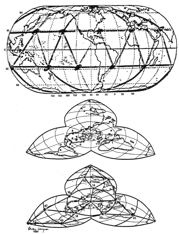
Illustration #15 Our goal in producing EarthStar was the creation of a map that would be comfortable to an audience oriented to the equatorial linearity and continental positioning of a standard Mercator map. It depicts major river systems, seismic zones, major ocean currents and the lines of the UVG 120 Polyhedron. The map is an excellent tool for distance estimation, as the sides of the Basic Triangle measure 1400, 2200 and 2600 miles respectively. (An interesting numerological coincidence: the sides of the Basic Triangle add up to 6200 miles, or one-quarter of the circumference of the earth). We believe that this map was used by ancient navigators of the seas and skies, who would have found these great circle routes the most convenient and efficient for long-distance travel.
Illustration #16 The UVG 4/30 Diamond centers on EarthStar will provide, we believe, the most fertile zones for research into the ancient history of the earth because they appear to be so geologically stable. In addition, there is a surprisingly full history of advanced cultures in these areas already established: the complex of Alexandria/Cairo/Jerusalem (point 1); a possible nuclear waste storage area postulated by Jalandris in Gabon (point 40): the People of the Four Corners (point 13); the sacred lands of the Hopi (point 17); the sacred lands of the Australian aborigines (point 44); the vast complex of megaliths and stone circles in the British Isles (point 11); the extraordinary Ugansk Bay Eskimo art complex (point 9); the ancient splendor of Amazonian cities now buried in vegetation (point 36); the Argentine Tafi megaliths (point 48); the contemporary site of major Soviet defense research (point 5). and the nearly unmatchable biological splendor of the Galapagos Islands (point 34).
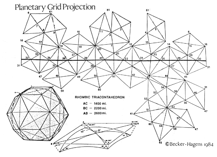
We have shortened that to Unified Vector Geometry (UVG) 120 Sphere, because of the form's elegant organization of 121 "great circles" running through its 4,862 points. We use the number 120 due to its easy comprehension as a spherical polyhedron with 120 identical triangles — all approximately 30', 60 and 90 in composition. All other forms within our Unified Vector Geometry use shape names and numbers which refer to the quantity of smallest UVG Basic Triangles within a given form — and the number of named forms in the UVG 120 Polyhedron or Sphere.
Thus, when we refer to our "Pac-Man" pentagons which appeared in our
first planetary grid map, you should know that we also call them UVG
10/12 Pentagons, because ten of our Basic Triangles create each
pentagon and there are twelve pentagons in the UVG 120 Sphere and
Polyhedron.
Also what we hadn't known until quite recently was that this triangle could predict so many kinds of events and geographic patterns, at so many times and places throughout human history. As mnemonic tools, the UVG Basic Triangle and 120 Sphere store and integrate biology, metaphysics, mythology, astronomy, geology, human struggle — or in the words of Pythagoras, "the supernatural within the finite."
Illustration #17
The geometry of EarthStar is the
rhombic triacontahedronprojection method developed by R. Buckminster
Fuller.We have continued to use the numbering system
originallypublished by Russian researchers.
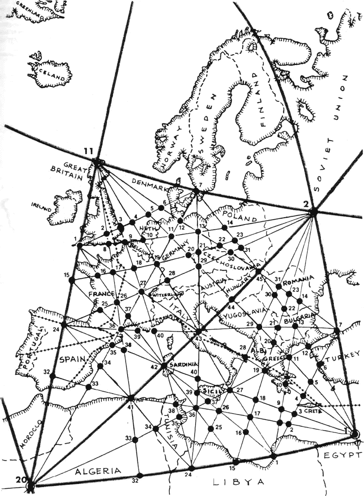
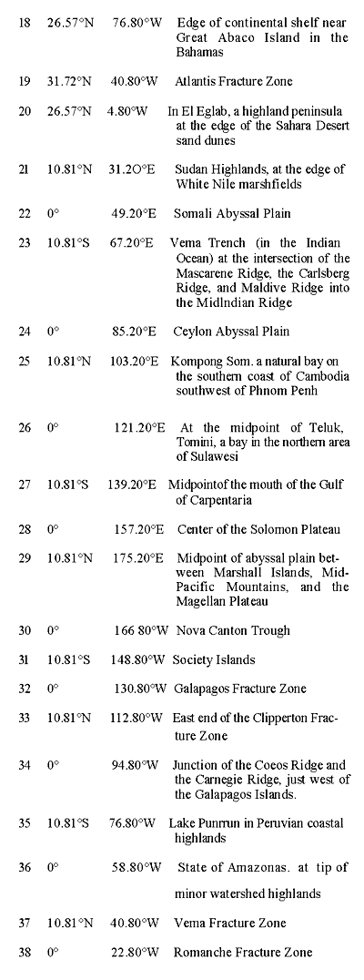
BASIC TRIANGLE Within the Basic Triangle's 30, 60 and 90 degree angles (whose lines and vertexes define 120 of those triangles, 62 major grid points, and 15 major great circles) are arrayed 45 intersection points and 16 lines which manifest 106 minor great circles and 4800 minor points over the face of the globe (UVG total is 4862 points). By noting the three numbers for the Basic UVG Triangle followed by a single number for a minor grid point (example — Oxford, England falls near 2-11-20/2 on our European maps); two numbers for a minor grid line (example — Italy's boot heel is defined by Basic Triangle 2-1-20/43-28 minor line).
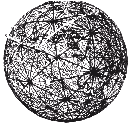
On September 1, 1983, in the pre-dawn sky, a 747 jumbo jet is cruising over the last island in the Aleutian chain. The Korean pilot is relaxed and having coffee as his autopilot is switched onto "Red Route 20," the standard course set for all airliners out of Anchorage to avoid coming within 25 miles of Russian territories north of Japan. At 3:18 a.m., Japan time, the pilot radios that his position is 115 miles south of Hokkaido Island in northern Japan.
Ground radar, however, locates the plane 115 miles north of Hokkaido and well into Soviet airspace. At 3:27 a.m., a garbled distress call goes out from the plane — the last message to be sent from KAL 007. Glance at our illustration of the path of the plane on the UVG 120 Sphere and imagine this scenario. KAL 007 crosses planetary grid point 6, approximately 1800 miles east/southeast of Anchorage, Alaska about 1:00 a.m. Thursday, September 1, 1983. The positions of the sun and moon begin bringing enormous energy into the vector line which stretches from the tip of the Aleutian chain to the Mongolian/Soviet mainland west of Sakhalin Island. (See illustration #19).
Silently, without alerting Captain Chun the pilot, the geo-compass in the autopilot's guidance system is slowly pulled 22.24° off its corrected north bearing, altering the course of the plane by that amount while simultaneously beginning to energize and speed up the magnetic odometer in the plane's computer navigational system. A fractional addition of a mile is added to each actual mile travelled at an accelerating rate. As the crew and passengers talk about the festivities ahead in Seoul, other smaller aircraft appear behind the 757 airliner. No communication takes place because the pilots of the smaller aircraft are never given international radio frequencies for fear they will defect.
Then an explosion, and another, thunder into the ears of the crew. Captain Chun begins his radio distress call, but in four short minutes the lives of all 269 aboard are gone. Compare the above to the flight of KAL 902 out of Paris, bound for Anchorage. The date is April 20, 1978. In the predawn sky over grid point 11, in northern Scotland, the 707's guidance system compass begins to read to an energized line running up from the Bermuda Triangle. Captain Kim Chang Kyu, a veteran KAL pilot, doesn't notice the bearing of his plane changing slowly to 82.25° off his near polar great circle route. The plane moves onto an infill grid line over Greenland.
By the time the plane moves into the next basic grid triangle, a passenger notices that the Arctic sun which had been on his right is now on his left. Before he can alert Captain Kyu, a Russian missile slams into the fuselage, killing two passengers and forcing the plane to land on a frozen lake south of Murmansk. As Russion troop vehicles appear on the shore, Captain Kyu apologizes to his passengers saying that he had felt something had gone wrong with his compass before the Russian planes had appeared.
Illustration #19
Both incidents, KAL 007 and KAL 902, were based on predawn
crossings of major grid points (6 and 11) by sophisticated aircraft
which then, unbeknownst to their crews drifted off their programmed
course and followed minor grid lines until shot down by
uncommunicative Russian pilots.
Illustration #20
A possible piece of supporting evidence comes from the Vail/Cyr canopy theory — which proposes a more equalized world climate during the Megalithic period (see footnote 7). If the global climatic ambience were more regularized than it is today, it is possible that grid energy manifestations were also more visible and potentially more available for applied use. Extending the speculation back further in time, the deluge myth round in the myths of virtually all cultures can perhaps be traced to some (Atlantean?) technological endeavor that caused a partial and devastating collapse of the canopy. Before this collapse, the poles may well have been free of ice (hence the existence of maps such as Piri Reis and Buache).
Polar ice caps may have formed relatively rapidly in the period of
climatic disequilibrium. In this light, Cyr's Megalithic canopy
theory is correspondent with our own findings in analyzing
Megalithic sites. We have documented in the illustrations of
Ireland, Britain, and Europe which follow; a patterned interface of
man-made constructions, dating to the Megalithic period, which
correspond to our proposed "infrastructure" for the icosa/dodecahedral
planetary grid. New evidence that we are just beginning to
analyze13, and which includes patterns of mounds within the central
United States and the curious "lines" of the Nazca area of Peru,
exhibits the same close correspondence. This proves to us that past
cultures have been aware of, and attuned to, the energies of the UVG
120 Sphere.
Satellite cameras
and infrared/radar instruments have already documented
thermal/structural energy developments along the globe's UVG 120
Polyhedral edges. It remains for traditional science to develop
instruments as sensitive as an experienced dowser's "earth sense"
before the full spectrum of the earth's electromagnetism can be
tuned like a "crystal set" radio to a wide range of frequency band
widths. (See illustration #20)
These energy flows are being mapped today both by dowsing groups interested in this rarest form of "harmony of the spheres" and ley line hunters (such as John Michell and others in the great tradition of Alfred Hawkins) who wonder at the coincident siting of modem towns and significant structures upon ancient stone remains from the past. (See illustration #22)
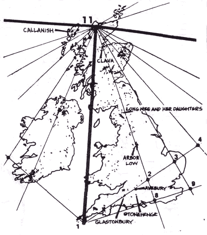
Illustration #21
Unobstructed minor grid energy lines focus into a
Basic Triangle corner in the British Isles, which have probably the
largest clustering of megaliths in northern Europe. Stone circles
are indicated by dots.
Both ley line hunters and dowsers have wondered at
the persistent site line-ups of ancient megaliths and more recent
sacred constructions (cathedrals, capital cities, shrines, etc.).
The diamond-pattern line superimposed on our map shows a
transcontinental system of energy ley lines published by Golin Bloy
an experienced dowser in Europe. Most of the line has been confirmed
by dowsing. The correspondence with the UVG 120 Sphere is apparent. In Triangle 11-20-2, we find Oxford (2); North Sea oil
deposits (4-5-6); Rotterdam (9); Hameln, village of the Pied Piper
(17); Berlin (13); Chartres (17); Alta Mira (24); Frankfort (19);
Barcelona (35); Cordoba (32); Hamburg (12); and Lourdes (line
24-36). In Triangle 20-2-1, we find Athens (10); Delphi (19); and
Assisi, home of St. Francis (43). We also hold that a major reason why Megalithic groups were so interested in astronomy and the precise calculation of solar and lunar phases was that within these calculations rested the predicted "pulses" of energy through the grid at different times of the year. Captain Bruce Cathie, an airline pilot and prolific grid researcher from New Zealand, has theorized for years regarding the grid's pulsing harmonic pattern and how it might relate to UFO and "sky light" phenomena. UVG is applicable to this research in a curious way.
R. Buckminster Fuller was constantly experimenting with
spherical packing — how many equal sized spheres can you fit into a
given polyhedron, and how can the arrangement be shifted (keeping
the same number of spheres) into a different one. As it happens, the UVG 120 Polyhedron shifts back and forth with the cubeoctahedron (or
vector equilibrium model, as Fuller calls it) that Cathie uses and
that seems to map UFO phenomena. We can hypothesize the heartbeat
of Gaia.
Spiritually and intellectually hungry travellers may well have visited major energy collection points on the grid, each having its own flavor and delight. The hand-held model, or map, attuned as it was to the solar system and to the monuments and towns one would pass along the way, was a complete tool for the voyager.(See illustration #24) It may even have charted the cycle of transcontinental festivals in much the same way that the Australian aborigines are able to coordinate huge religious gatherings with (seemingly) no deliberate planning. The "bureaucracy" is maintained only in the flow of time through lines of kinship, lines of sight, and sacred lines of the tchuringa.
Footnotes
Back to Contents Antigravity And The World Grid
|
 Bill Becker (Professor of Industrial Design at
the University of
Illinois, Chicago) and Bethe Hagens (Professor of Anthropology at
Governors State University) are a husband-wife team. In 1981,they
started a product and graphics design partnership. Conservative
Technology. Contact them at 105 Wolpers Road, Park Forest, Illinois
60466.
Bill Becker (Professor of Industrial Design at
the University of
Illinois, Chicago) and Bethe Hagens (Professor of Anthropology at
Governors State University) are a husband-wife team. In 1981,they
started a product and graphics design partnership. Conservative
Technology. Contact them at 105 Wolpers Road, Park Forest, Illinois
60466.