|

by Rob Waugh
3 July 2012
from
DailyMail Website
Spanish version
Italian version
Divers have found traces of
ancient land swallowed by waves 8500 years ago
Doggerland once stretched from Scotland to Denmark
Rivers seen underwater by seismic scans
Britain was not an island - and area under North Sea
was roamed by
mammoths and other giant animals
Described as the 'real heartland' of Europe
Had population of tens of thousands - but devastated by sea level
rises
'Britain's Atlantis' - a hidden underwater world swallowed by the
North Sea - has been discovered by divers working with science teams
from the University of St Andrews.
Doggerland, a huge area of dry land that stretched from Scotland to
Denmark was slowly submerged by water between 18,000 BC and 5,500
BC.
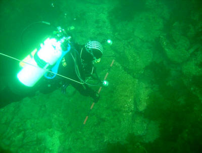
Divers from oil companies have found remains of a 'drowned world'
with a population of tens of thousands - which might once have been
the 'real heartland' of Europe.
A team of climatologists, archaeologists and geophysicists has now
mapped the area using new data from oil companies - and revealed the
full extent of a 'lost land' once roamed by mammoths.

Divers from St Andrews University, find remains of Doggerland,
the underwater
country dubbed 'Britain's Atlantis'

Dr Richard Bates of the earth sciences department at St Andrews
University,
searching for
Doggerland, the underwater country dubbed 'Britain's Atlantis'
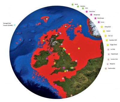
How the North Sea
grew and the land-mass shrunk
A Greater Britain: How the North Sea grew and the land-mass shrunk
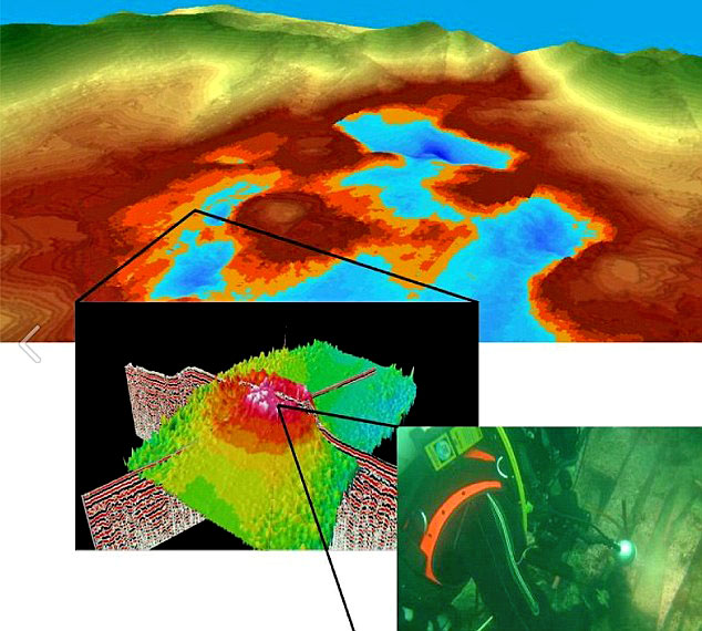
Scans show a mound discovered under the water near Orkney, which has
been explored by divers

Drowned world:
Scans show a mound
discovered under the water near Orkney,
which has been
explored by divers

St Andrews University's artists' impression of life in Doggerland
The research suggests that the
populations of these drowned lands could have been tens of
thousands, living in an area that stretched from Northern Scotland
across to Denmark and down the English Channel as far as the Channel
Islands.
The area was once the ‘real heartland’ of Europe and was hit by ‘a
devastating tsunami', the researchers claim.
The wave was part of a larger process that submerged the low-lying
area over the course of thousands of years.
'The name was coined for Dogger
Bank, but it applies to any of several periods when the North
Sea was land,' says Richard Bates of the University of St
Andrews.
'Around 20,000 years ago, there was a 'maximum' -
although part of this area would have been covered with ice.
When the ice melted, more land was revealed - but the sea level
also rose.
'Through a lot of new data from oil and gas companies, we’re
able to give form to the landscape - and make sense of the
mammoths found out there, and the reindeer. We’re able to
understand the types of people who were there.
'People seem to think rising sea levels are a new thing - but
it’s a cycle of Earth history that has happened many many
times.'
Organized by Dr Richard Bates of
the Department of Earth Sciences at St Andrews, the Drowned
Landscapes exhibit reveals the human story behind Doggerland, a now
submerged area of the North Sea that was once larger than many
modern European countries.
Dr Bates, a geophysicist, said:
‘Doggerland was the real heartland
of Europe until sea levels rose to give us the UK coastline of
today.

World beneath the
waves:
Scientists examine a sediment core recovered from a mound
near Orkney

Seismic scans reveal a submerged river at Dogger Bank

Doggerland
A visualization of how life in the now-submerged areas
of Dogger
Bank might have looked
The research suggests that the populations of these drowned
lands
could have been
tens of thousands, living in an area that stretched from
Northern Scotland
across to Denmark
and down the English Channel as far as the Channel Islands

Life in 'Doggerland' - the ancient kingdom once stretched
from Scotland to
Denmark and has been described as the 'real heart of Europe'
‘We have speculated for years on the
lost land's existence from bones dredged by fishermen all over
the North Sea, but it's only since working with oil companies in
the last few years that we have been able to re-create what this
lost land looked like.
‘When the data was first being processed, I thought it unlikely
to give us any useful information, however as more area was
covered it revealed a vast and complex landscape.
‘We have now been able to model its flora and fauna, build up a
picture of the ancient people that lived there and begin to
understand some of the dramatic events that subsequently changed
the land, including the sea rising and a devastating tsunami.’
The research project is a collaboration
between St Andrews and the Universities of Aberdeen, Birmingham,
Dundee and Wales Trinity St David.
Rediscovering the land through pioneering scientific research, the
research reveals a story of a dramatic past that featured massive
climate change. The public exhibit brings back to life the
Mesolithic populations of Doggerland through artifacts discovered
deep within the sea bed.
The research, a result of a painstaking 15 years of fieldwork around
the murky waters of the UK, is one of the highlights of the London
event.
The interactive display examines the lost landscape of Doggerland
and includes artifacts from various times represented by the exhibit
- from pieces of flint used by humans as tools to the animals that
also inhabited these lands.
Using a combination of geophysical modeling of data obtained from
oil and gas companies and direct evidence from material recovered
from the seafloor, the research team was able to build up a
reconstruction of the lost land.
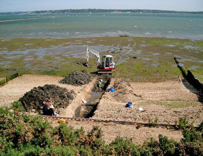
The excavation of
Trench 2,
unveiling more finds
about this lost land-mass

Fossilized bones from a mammoth also show
how this landscape
was once one of hills and valleys, rather than sea
The findings suggest a picture of a land
with hills and valleys, large swamps and lakes with major rivers
dissecting a convoluted coastline.
As the sea rose the hills would have become an isolated archipelago
of low islands. By examining the fossil record - such as pollen
grains, microfauna and macrofauna - the researchers can tell what
kind of vegetation grew in Doggerland and what animals roamed there.
Using this information, they were able to build up a model of the
'carrying capacity' of the land and work out roughly how many humans
could have lived there.
The research team is currently investigating more evidence of human
behavior, including possible human burial sites, intriguing standing
stones and a mass mammoth grave.
Dr Bates added:
‘We haven't found an 'x marks the
spot' or 'Joe created this', but we have found many artifacts
and submerged features that are very difficult to explain by
natural causes, such as mounds surrounded by ditches and
fossilized tree stumps on the seafloor.
‘There is actually very little evidence left because much of it
has eroded underwater; it's like trying to find just part of a
needle within a haystack. What we have found though is a
remarkable amount of evidence and we are now able to pinpoint
the best places to find preserved signs of life.’
For further information on the exhibit,
visit:
http://sse.royalsociety.org/2012/exhibits/drowned-landscapes/
|