|
by Joan T. Griffith from GoldenPlanerForum Website
There’s much mystery and confusion, garbled tales and misinformation about the Lost Continent of Lemuria, but even more concerning the man who spent a lifetime trying to put it in its rightful place on the map, Colonel James M. Churchward, author of the Mu books.
Before the shock waves had settled, the Colonel followed quickly with his companion editions, The Children of Mu (1931), The Sacred Symbols of Mu (1933), and Cosmic Forces of Mu in two parts, 1934-35.
He had prepared notes for this next volume, Books of the Golden Age, published in 1997, and had started work on Traces of Mu in America.
Although he amassed an instantaneous cult-following among his leadership, he also managed to tick off members of the conservative scientific community, religious leaders, and literary critics with his emphatic claims.
Seventy-five years later, it seems odd that such a furor arose: after all, in 1924. only two years prior to the Colonel’s first work, John MacMillan Brown, a retired professor at Canterbury University College, introduced his Riddle of the Pacific, claiming there was once a continent in the Pacific, now submerged save for island groups, on which megalithic ruins still existed.
His forty years of exploration in the area, as well as research into ancient records (lie once saw part of an old map showing a sunken continent, he stated) made his tale convincing.
So there was more to support Lemuria’s existence than just the material from Occultists Rudolf Steiner, Madame Helena Blavatsky, and Scott-Elliot.
The etymology is confusing at best: Lemuria allegedly received its name first though English naturalist Philip Lutley Schlater who dubbed it that in 1870 to designate the land-route lemurs used to spread from Madagascar to New Guinea, in his Geography of Mammals (London, 1889).
German biologist Ernst Heinrich Haeckel popularized the theory also in his 1876 History of Creation.
This leaves the obvious question, what then was its name for the hundred thousand years or more that it was said to have existed’? Or, the period up to 1876, even’? And where did the lemur get its name? A more likely scenario is that the name derived from ancient Romans’ use of the word "Lentures" to describe spirits of their dead ancestors.
One of the Mayan codices that survived the Spanish conquest, The Troano manuscript (now in the British Museum), describes the destruction of Mu "8060 years before the writing of this book" - which is approximated at 5,000 years old.
From these clues we might deduct that possibly La-Mu-Ra was the original name, after one of the destructions which divided the land into islands, the shorter names were given to those groups which may represent today’s:
The lemurs undoubtedly derived their name from these old roots, returning the favor to their old homeland, via Sell later and Haeckel!
The problem of Lemuria has long taken a back seat to the more popular Atlantis ’legend,’ being of even more ancient vintage, but there is considerably more identifiable evidence for its existence in the Pacific, with its hundreds of megalithic ruins on land and in shallow water, obviously pre-Polynesian, that defy explanation of their origin.
Atlantis jealously retains its secrets thousands of feet down, under water, slime, and perhaps the sea bottom itself. But with recent geological events, suddenly what might have happened to Lemuria (and Atlantis) have become relevant to earth’s future.
And Churchward’s research, his explorations and theories, are being given a new look in the light of new technological advances, and an ability to access many ancient, esoteric records through the Internet. Many of his findings, once ridiculed, have been proven and cross-proven; notch data is still being debated.
The chain contains,
Many of these belch steam and rocks from time to time: Shasta experienced a 3.0 quake on Nov. 6. 2001, a rare event.
Helens had just suffered over 100 tiny tremors; Sisters shows activity currently with an increasing bulge. Are these harbingers of future violence? This chain, he contends, is connected to three Mexican volcanoes by a gas-belt system far beneath the earth’s surface (12 to 18 miles), and when a block develops along the belt, earthquakes result if the block is not blown off by volcanic eruption along the he It-line.
Churchward, before the discovery of tectonic plates which divide up the earth, contended that these gas-belts circumtraverse the globe, with chambers that underwent coil apse at certain times in prehistory, causing subsidence and submersion of lands.
This is what, lie stated, caused the sinking of Mu, and why it occurred so swiftly; lie quoted the Troano manuscript, which described the "loss of 64,000.000 souls."
Edgar Cayce connects the two geological events in a predicted warning made 60 years ago:
Many modern-day geologists are warming to the gas-belt idea (excuse the pun).
Arthur Holmes from University of Durham. England proposes a theory of convection within the earth’s interior: an Irish scientist, John Joly enlisted convection from radioactive decay as fundamental to mountain-building, back in 1925, with his Surface History of the Earth. In the 1930s Dutch geophysicist Felix Vening Meinesz advocated thermal convection as a process operating within the earth’s interior, basing his concept on the gravity anomalies he found over the ocean trenches and island areas in the W. Pacific.
Three decades ago, W. Jason Morgan of Princeton presented his Plume theory, whereby 20 stationary hot-spots exist beneath the moving lithosphere, originating from convection at the mantle-core boundary and resulting in volcanoes, steam vents and springs.
In 1972 Peter Vogt of the U. of So. California enlarged upon this, speculating that plume discharge runs in cycles, corresponding with increased volcanic activity which in turn hurls volcanic dust particles into the upper atmosphere, changing the climate and affecting the amount of solar radiation we receive, causing magnetic field variations, movement in the lithospheric plates and subsequent earthquakes.
This fits in with the claim of Cornell’s Dr. Thomas Gold, that methane gas deposits lie deep in the earth, in huge chambers. His articles have appeared in Nature, Scientific American, Science Digest, and OMNI. Gold further contends that when some of this methane is pressurized, or trapped tinder rock, it converts into oil.
He is in direct opposition to oil professionals, who hold the belief that oil comes from decayed living matter like prehistoric flora and fauna, now in alleged "scarcity." (Gold allows for some biologicals seeping into the methane.) In 1991, a discovery was made of a massive coal deposit in Victoria’s Latrobe Valley, underlain by white kaolin clay - hardly an indication of swamp origin! (Victoria’s Secret indeed!) In this new millennium, it is of vital importance to ascertain the truth of oil’s origin, so that hostile countries are not depended upon for its supply.
What vested interests could be lurking in clinging to the old false story of limited resources’? Who benefits from this?
Strangely, James Churchward’s main claim to fame was not publication of the MIL books, but his inspired invention of NCV Steel, the patent wars surrounding it, and its manufacture for use by the USA and Allies in WWI.
As oil conglomerates rule the financial world in 2002, the "steel juggernaut" as Churchward called it, was all-powerful in 1907, when the Colonel first patented his "perfect alloy," termed impenetrable by metallurgists who had been trying to achieve the wonder formula for years, without success.
Percy Tate Griffith, his patent attorney and lifelong friend (and father of this writer) eventually won $275.000 for the Colonel in a patent infringement case against Carnegie Steel (1910) and a million dollars in a judgment against Bethlehem in 1915, though this latter was reversed by Supreme Court decision (U.S. Letters Patents #845.756 - March 1907; #868,327 - Oct. 1907; #884,009 - April 1908).
So in 1937, after Churchward’s death, P.T. wrote a 62,000 word biography, "My Friend Churchey and his Sunken Continent of Mu."
James M. Churchward, born in Devon, England in February 185 1, arrived on the Brooklyn scene by 1880, becoming a kind of foster father to P.T. (l 870-1950) and close friend of his widowed mother.
Early Churchward history remains foggy, with no records available about his schooling (ostensibly at Sandhurst & Oxford) or his military career, allegedly in the British Army as a Colonel of Engineers, and as Colonel of a regiment of Lancers stationed in India. P.T. treasured his photo of the Colonel in full uniform, but his commission may have been brief.
He married in India at age 20 and had a son, Alexander, in 1872. He was in charge of a tea plantation for some years, and while in India, befriended a Rishi at a temple school monastery (possibly Hemis), learning about Mu ("The Motherland") from countless Naacal tablets of clay, written in Naga, allegedly around the time of the last destruction of Mu 12,000 to 14.000 years ago.
There were, according to ancient texts, 10,000 tablets, 8" x 10", half of which were transported from Mu to the Uighur Library; as of 1927 the Khanassa temple monastery had 8,000 or 9,000 of them, the rest spread among six other temples, including Katsupari Monastery and the Temple of the Great Tau Cross in the Tibet/China region; some Naacal "scriptures" were rumored to be at Kurdestan in 1957. "Naacal" means "Holy Mother" which implies Motherland Mu.
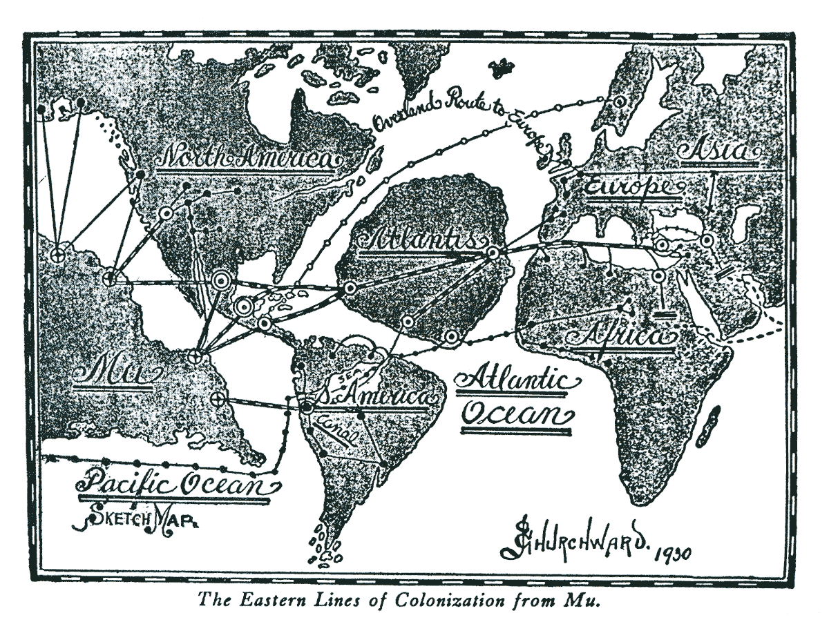
Now he was impressed with tales of Central America and Mexico having been peopled by émigrés from a sinking Atlantis, as Le Plongeon insisted. James argued that there was more evidence for an exodus from Mu west to the Americas.
Evidence shows they were both right: Cayce Readings (derived from accessing Akashic Records) cover both civilizations.
In one, Cayce says
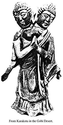
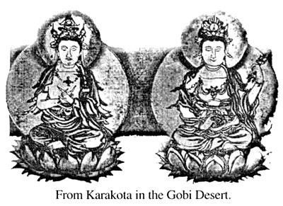
This Temple was in what is now the Gobi Desert (then fertile and temperate), the buried ruins of Kara Khota, legendary "City of Gold," (excavated partially by Russian archaeologist Peter Kozlov in 1896) due west of Ulan Bator, capital of Mongolia.
So Naacal tablets tell an identical tale to that imparted by countless far-flung records, codices and texts.
Churchward references some two or three hundred sources, an amazing achievement back in pre-Internet times!
"Churchey," as P.T. dubbed him, took work as a civil engineer, inventing some railway spikes, lock-nuts and tie-plates for the Bangor & Aroostock Railroad, as their sales rep.
The 1890s saw him in Central America and Mexico on a protracted trip to check out Le Plongeon’s findings, and further investigate William Niven’s archaeological digs 30 miles from Mexico City, where three layers of civilizations had been unearthed, buried under volcanic debris and dating from 40,000 BC. Finances were not good for Churchey during this period, and P.T. - now a successful patent attorney in downtown Manhattan with a clientele ranging from Edison to Troubetzkoy to Hammerstein to Gillette - loaned him grubstakes occasionally.
Nickel hardened steel, but it wouldn’t cut. Chrome steel was fair; vanadium was disappointing and expensive.
The Colonel found that only by using small proportions of each of the elements in such relations that if you increased or diminished the nickel-content you must correspondingly adjust all the others, could you produce the steel. The mathematical combinations were infinitesimal. Then, he processed the alloy at a higher temperature than ever before tried in the trade, with certain ingredients added last.
The Rishi had shown him ancient Hindu holy writings describing early metallurgy, where extreme heat temperatures were used in metal allay melts! The contained secret formulas now lost to the ages, like that of the sacred pillar in New Delhi, composed of an iron that never rusted! Could he explain his psychic intuition that led him to the ultimate recipe?
He could have told them,
...concludes Karl Hempel in Aspects of Scientific Explanation.
Modern traditional scientists have long abandoned this paradigm (if they ever followed it), insisting on step-by-step progress and duplicatible results. Psychic hunches are not welcome in the lab.
Yet Fritjof Capra, a theoretical physics researcher, states in The Tao of Physics,
Despite years of struggle by P.T. and the Colonel to market NCV following WWI, steel bigwigs had successfully blacklisted the alloy, and finally a dispirited James sold the Churchward International Steel rights to a small company.
The brouhaha had brought names like U.S. Steel’s Judge Eugene Gary, J. P. Morgan, and a Krupp Munitions rep to the courtroom, and P.T. was flummoxed when contacting close connections from Miami Beach to Washington. The word was out: NCV was taboo, as politics, finance and the "Steel Juggernaut" closed ranks.
The "cradle of civilization," Le Plongeon believed, was in Atlantis, and Mu-ans came after, or maybe were transplanted Atlanteans. Not so! countered the Colonel; Hindu records proved Mu to be the motherland. In the last analysis, Lemuria doubtless preceded its eastern counterpart as the primal spot where man first appeared which, according to Cayce, was 10-112 million years ago, in a material body considerably less dense than now.
Philostratus, in "Life of Tyana," says "the first Egyptians were a colony from India" and historian Valniiki, in the Ramayana, writes:
Supposedly, this preceded the colony started at Sais, the "mouth of the Nile" by Thoth, son of an Atlantean priest, in 14,000 BC, with a temple for teaching the Osirian religion.
According to Cayce. by 10,090 BC the Atlanteans had arrived from their sinking continent, adding to the conflict between the Egyptians and attackers from Carpathia (Ibex Rebellion).
During this time the Great Pyramid was built, with Hermes (Thoth) principal architect; the Sphinx was "already there." With this suggestion of black (Africa), red (Atlantis) and white (Carpathia) races within pre-dynastic Egypt, it is not surprising to find wall paintings still extant in Egyptian temples and pyramids depicting all three. Original Lemurians (brown race still existing in Pacific regions) and those from the Gobi (yellow) or their descendants found their way as well to Egypt, the melting pot 15 millennia ago.
The white and yellow races sojourned southward, according to Cayce, with the,
While Churchward toured India for the last tine - presumably between writing his first and second books - it isn’t known whether he visited the same temples and monasteries where he had spent years in his early manhood, in discourse with the Rishi and studying tablets and scrolls in Pali, Sanskrit, Tibetan.
Chaldean, and Uighur. In one of the western Tibetan monasteries he viewed a map which showed South America as it was 20.000 years ago, with an Amazonian Sea occupying the jungle area. Canals connected it with the Pacific coast, a water route between Mu and Atlantis, south of Tiahuanaco. (click above image to enlarge)
The "Lost City of Gold," Manna, is pictured due south of the Amazon, on his illustration in The Children of Mu. Churchward’s contention that Tiahuanaco was built at sea level 16,000 years ago, and attained its present 13,500 ft. height when the Andes were raised during the last cataclysm (10,090 BC), makes sense as marine shells are found in the vicinity.
South American geologist E.B. Enock concurs with this explanation in his book on Peru. Maya writing and symbols on one of its monoliths are said to date its construction.
The Mu books, having been the result of 65 years of the Colonel’s research and travels, contained over 200 sources to sustain his redux of world prehistory.
These included:
Most of all, at a time when few could travel great distances, he provided descriptions and illustrations of innumerable megalithic ruins throughout the Pacific region, proof that an advanced civilization occupied a large continent in times past.
A civilization capable of constructing immense stone structures, walls, roads and temples of 30- to 50-ton blocks, by unknown means, unduplicatible by today’s engineers.
Such ruins can be found on small islands at landlevel or leading into the sea; some stonework is not native to the island it’s on, originating as much as 300 miles away on another islet.
Easter Island is almost a cliché, as is Nan Madol, but sites just as unique exist at:
Hawaii is a hot spot, boasting petroglyphs on stone, walls and platforms at:
More descriptions and newer illustrations of these sites can be found in David Hatcher Childress’ Lost Cities Of Ancient Lemuria & the Pacific, Ancient Tonga, and Ancient Micronesia.
What an oasis of discovery for geologists, archeologists, anthropologists, or university groups! A bigger mystery than Lemuria is why more light isn’t being thrown on the origins and dating of such wonders. And time is winding down; already, due to the polar ice melting and rising ocean levels, a few Pacific islands have experienced flooding and erosion; larger lands have noted salt water seepage into their fresh water.
Dr. J. Johnstone of Liverpool University, in Introduction to Oceanography, says,
Says Dr. F.R.C. Reed in Geography of the British Empire:
According to Sir Archibald Geikie,
Flat-topped guyots (sea-mounts) are formed above water, and these are numerous throughout the Pacific, now submerged.
One such guyot, termed "the largest sea-mount in history" by its peak 11,000 feet undersea, was located 700 miles cast of Hawaii by the Scripps Institution of Oceanography scientists in 1951. Coral too, gives silent testimony, as it can grow only under the surface of water to a depth of 150 feet; rings of coral have been found in the South Seas 1,800 feet deep, meaning that those areas went down slowly over an extended period of time.
Though Churchward implies an "overnight destruction of Mu" (from Troano records), this might refer to any of three separate cataclysms from 50,000 BC to 10,900 BC, the dates given by Cayce and other sources to the first and third destructions, with a second event at about 28,000 BC. Magnetic pole reversals, or even axis shifts, may have accompanied or helped cause submergence.
The usually staid Smithsonian Institution, in its November 1955 annual report, announced that Dr. Albert C. Smith, one of its botanists, had collected evidence indicating the existence of a large continent in the Southwest Pacific some 20 million years ago.
Smith’s study of plant life similarities in Pacific Islands supports the continent’s existence, embracing New Guinea and Australia. He found that Fiji plants showed affinity with plants of Papua, Solomon Islands and New Hebrides. The diffusion of flora and fauna iii these far-flung islands is one of the undeniable arguments for the existence of a Mu.
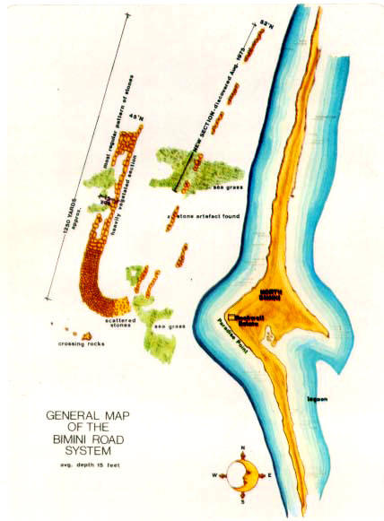
He was supported by J. Manson Valentine of the Miami Museum of Science (noted for his explorations of megalithic stone "J" formation off Bimini, -below image- in the 1960s and ’70s) who was convinced, as a biologist, that a continent did exist in the mid-Pacific, based on this evidence.
In his "Development of Median Elevations in Ocean Basins" (1958, Geological Society American Bulletin, Vol. 69, pp. 1179-1186) H. W. Menard finds that:
The exciting discovery of a vast layer of "clean white ash" on the Pacific Ocean floor a few hundred miles from C. and S. America, extending 750 miles to the west and 825 miles to the south of the equator, was reported in the New York Times of April 12, 1959.
Its origin was suggested as being from probable widespread volcanic action, or even falling debris from the breakup of asteroids. But E. Anders and D.N. Limber ("Origin of the Worzel Deepsea Ash" in Nature, Vol. 184. 1959) believe the ash to be terrestrial, and that the layer must have "recorded a notable event in the earth’s history."
Some corroboration is provided in the discovery of large amounts of volcanic dust completely mixed in the Alaskan, Asian and Siberian "muck," indicating volcanism occurred at or just before the phenomenon which instantly flash-froze entire herds of imperial mammoths 10,000 years ago. Obviously, no "gradual climactic change" at work here?
The extinction of Siberian mammoths was an insoluble problem to Charles Darwin, who from early on preferred the idea of gradual climactic change, but later wrote in his classic "Journal of Researches into the Natural History & Geology of the Countries Visited During the Voyage of H.M.S. Beagle Round the World":
An amusing anecdote was related by Charles Berlitz: frozen mammoth was served to scientists at a Moscow banquet; and members of the Explorer’s Club in NYC had 40,000-year-old frozen horse dished up to them, straight from Alaska, at a 1972 banquet, with good reviews.
Diners doubtless found the entree more palatable than its implications.
Many areas, which appeared on maps as deep blue spots, contained extensive elevations and individual mountains, as well as great accumulations of ancient animal remains, and prehistoric sharks’ teeth. A few years later Dr. Robert J. Menzies. director of Duke University’s Oceanographic Program, and his colleagues spotted and photographed carved rock columns resting on a muddy plain 6.000 ft. underwater, in the 600-mile-long Milne-Edward Deep, a trench off the coast of Peru.
And by 1977, Amos Nur, a Stanford geophysicist, averred that a "Pacifica" was a probability, as crust centers originate under continental masses, except in the Pacific, and that,
One could surmise that if the Pacific ocean basins had for eons been "bathtubs" into which detritus from the continents was sluiced, then the sea floors would be found covered with great thicknesses of sediment.
And conversely, if there had been continents in those areas recently, hardly any thickness of deep-sea sediment would be found, merely a thin layer draped over a very rough topography which had once been above water, subjected to weatherizing and stress action ("subaerial topography"). And which condition was found by a sub-bottom depth profiler?
According to Science magazine, Dec. 1963, Vol. 142:
Theorizing proves unnecessary, when one has physical proof at the ready.
In the town library at Nance, France there is a globe, six inches in diameter, with a recorded history dating back to 1531; its continents of N. and S. America are accurately drawn but the peninsula of California is shown as an island with a group of smaller islands at its southern tip: water covers the area of the Santa Clara, San Joaquin and Sacramento valleys. An illustration of this globe can be seen in Walter Cerve’s (Wishar S. Cerve - pseudonym of Harve Spencer Lewis) Lemuria-The Lost Continent of the Pacific.
Cerve sees this west strip of California as a remnant of the E. coast of Lemuria following avulsion.
Citing as evidence the richness of valley soils, and seashells imbedded in Santa Clara’s deep soil. Cayce, too. stated that,
In old Indian legends, Santa Catalina’s original name was "Pimu" ("land of sunken mountains") including two volcanoes; and San Miguel Island was called "Limu."
This site is filled with elephant bones, and those of condors, sloths and a 14-ft. winged bird. Professor William Orr from U. of Oregon, after having the hair lab-tested, found that its DNA did not match that of Asian, African or European; there is a plan to compare it with Japanese. Why not compare it with certain Pacific islanders’ hair DNA?
You might be in for a shock.
Or quick-flooded, buried in layers of silt and muck?
This is the date given by Cayce, Churchward and others for the last destruction of Atlantis and Mu: 10,090 BC. And traditional science recognizes the fact of huge flooding at the end of the Pleistocene Era, 11 or 12 thousand years ago. Bruce Heezen, oceanographer of Lamont Geological Observatory, showed that the sea level underwent a rise of 100 to 150 meters world-wide at about 11,600 BP (before present) due to melting glaciers.
A flood of icy water poured down the Valley of Mississippi to raise the Gulf waters 130 feet. With this in mind, in summer of 2000 Mike Arbuthnot, a "submersed prehistoric archaeologist" with Florida State University, unearthed flints, arrowheads, stone tools and three complete spear points four miles off NW Florida’s Apalachee Bay region, in the Gulf at a depth of 15 feet and dated at 11,500 years. Fragmented skeletal remains of mastodons, ancient horses and tapirs were found here too.
This shows not only that this "Panhandle" area was dry land at that time (its coast was 90 miles farther out also), but is the earliest proof to date of early man’s arrival in N. America by another entry port than the over-used Bering Strait, which was obviously not chosen by humans as a means to get from Asia (or Japan or Pacific Islands or Mu) into N. America and southeast to the Alabama Gulf - a distance of 8,000 to 15.000 miles or more by boat and on foot! Hello’?
PS. - No "Clovis" spear points have ever been found in Siberia or NE Asia where migration was supposed to have originated over the Bering Strait.
So where did these "first N. Americans" originate?
Conventional science guesses: from Europe by boat, via S. America (all of a sudden, scientists are willing to concede that these "primitives" just out of a cave, could construct and maneuver a large seacraft across the Atlantic). Close, but no cigar - Atlantis was vastly nearer, and probably just beginning its countdown to exodus.
The vernal point coincided with the center of Leo (occurring 11,600 years ago) from the famous Zodiac of Dendera, copied from far older versions.
From tales of a deluge to legends of cataclysm and sunken lands, is a mere step. References to an Atlantean land submergence come from Celtic, Frisian, Roman, Greek, Egyptian, Spanish - and as many concerning Mu. Hindu traditions affirm that the first Sangham (poetic academy) lasted for 4,400 years; the second one for 3,700 years; the third one (up to the Christian era) lasted 1,850 years. Total, 11,900 years BP for the start of Sanghams, which began "shortly after the flood."
Fanatics have eliminated the best resources, such as the Library at Alexandria, the Mayan Codices, many Buddhist temple records, so that proof of antiquities must be collated bit by bit from fragmented sources, esoteric writings, heavily guarded sacred texts, and from those who have a proven ability to access Akashic Records.
But countless ruins remain, the construction of which cannot be copied today with our advanced engineering techniques. And science will ultimately clear many a mystery, as tiny advances are made slowly in the field.
A more reasonable explanation of what occurred during the Glacial Period, which indeed included a cataclysm, is explained by James P. Dana in The Geological Tale.
Boulders and stones, gravel and sand were transported in huge drifts, over the N. latitudes of America and Asia. Over hills it is unstratified drift; in river valleys it is stratified drift. Although geology asserts that the "ice cap" extended around the N. hemisphere, it doesn’t mention E. Asia and Siberia!
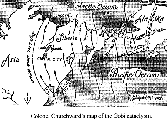
That, explains Churchward, is because there had not been ice accompanying the Asiatic wave of water which did flood over the NE parts of Asia, gathering up the animal life roaming the plains, including mammoths, carrying them up to the Arctic Ocean, and depositing them in hulk at the mouth of the Lena River, with the bones forming Llakoff’s Island.
Had there been ice accompanying the water wave, the bodies and bones of the animals would have been ground to a pulp, as they were in Europe and N. America, and there would have been no Llakoff’s.
Moreover, the climate was mild and temperate in the NE parts of Asia, shown by the animal life sustained by abundant vegetation. It is virtually impossible for one half of the northern hemisphere to have an ice cap thousands of feet thick while the adjoining half on the same latitude was enjoying a temperate climate! Remember the buttercups in the mammoth’s stomach?
It wasn’t ice that killed these beasts, but a reversal of the poles, so that temperate zones became frigid, cold became torrid. Floods occurred, and land subsidence. It was the time of the last destructions of Mu and Atlantis, both mostly in a series of islands by that time, instead of their former continental size.
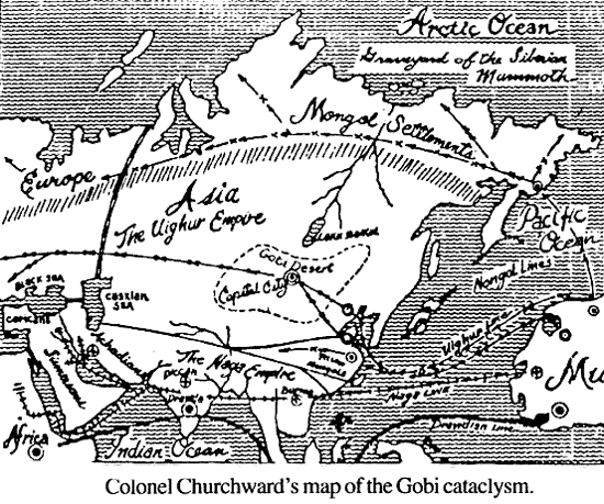
Instead of enduring an Ice Age, the present Gobi Desert was then a fertile land holding great cities, including the Uighur capital Kara Khota, now buried beneath 40 to 50 feet of sand and gravel.
At the time of this great flood, says Churchward, the gas-belts had not been formed nor the mountains raised.
Why there are scratches left by boulders on the tops of Appalachian mountains is explained by the fact that they were carried along by water, with a little ice, across the plains before the mountains were raised.
It is absurd, says Churchward, to imagine a glacier with a 20.000-foot thickness (the amount it would take to form an ice cap around the northern part of the N. Hemisphere down to the 40th Parallel!), for it would require more water than now exists in all the oceans! It couldn’t cross the (nonexistent) Labrador Mountains (which would have had to be 60,000 ft. high), the 7.000 ft. high Adirondack, sink into the valleys, and surmount the Catskills after losing 17,000 ft. in the Mohawk valleys... and so on!
A glacier can’t slide, unless it’s putty, so what propelled it?
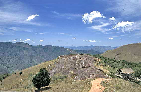
The Ice Age is a handy ploy used by dogmatists in order to avoid explaining a cataclysm and submerged continents. That the mountains were raised in recent times is further proven by sites like Tiahuanaco in Peru, built in 14,000 BC at sea level, now at an elevation of 13,500 ft. in the Andes, from the raising of the mountain range.
Oriental records describe the "raising of the mountains," and there are Biblical references (Psalms) to the time "before there were mountains."
Zulu legend tells of the tribes fleeing N. Africa, ruined by mountain raising, settling in the south. Churchward’s explanation is that the upward thrust is caused by inner workings of the earth, as the gas-belt system was formed and subsequently underwent the first blowing out of its Archaean chambers during the Tertiary Era.
A classic example of land upheaval is the Valley of Mexico, now at 7,000 above sea level, but estimated by Churchward to have existed at sea level until about 12,000 years ago, with its pushed up by exploding subterranean gases. Cayce warned an oilman (in a 1940s Reading) not to drill in the Mexico City area, as its foundations were honeycombed and would collapse if oil were extracted - a scenario reminiscent of the Colonel’s description of how the continent of Mu collapsed, as supporting chambers blown out, with subsidence and submergence.
Certainly there is evidence of tidal waves sweeping across the Valley, carrying sand, gravel, and rocks on more than one occasion in the last 40,000 years.
In the 1910s explorer and mineralologist William Niven stumbled upon a series of pits which reached 30 feet in depth, in an area of 10 x 20 miles in the NW Valley between Texcoco and Haluepantla. Between strata of sand/pebbles, there were layers of ancient ruins, prehistoric cities at 9 to 14-ft. intervals, with the lowest buried city (and third pavement down) beneath a layer of volcanic ash.
Artifacts with Phoenician, Semite, and Chinese features were dug from the bottom layer. By dating these layers, one would presumably arrive at time-frames corresponding with each of the dates of Lemuria/Atlantis destruction (10,900 BC, 28,000 BC, 50,200 BC), and an influx of different cultures in between the layers of flood debris.
The second of Niven’s unusual finds (1921-23) was a vast number of carved stone tablets with pictographs at a 12-foot depth in pits near Amantla, five miles NW of Mexico City. In all, he amassed over 2,600 tablets, which he placed in a private museum in Mexico City before his death in 1937. When these were seen by Churchward, he joyously exclaimed they were similar, though smaller, with like inscriptions, to the Naacal tablets in Tibet, copied from records of Mu.
The priestly brotherhood, he said, had been sent out from Mu to teach the sacred writings of religion and science to colonists in southeast Asia, then India. Though Churchward was unaware, a man named Edgar Cayce was soon to access information which would support these claims (independently of the Colonel’s research as the two men had no contact).
Said Cayce:
And,
To support both Churchward and Cayce, there are traces of far-flung civilizations in the Negroid and Semite-featured statues of Olmecs in Oaxaca and Monte Alban (below images); the likeness of a bearded Tlaloc at Tula, Chinese jade found in Niven’s lowest city; evidence of Phoenician voyages in Azores and near Cape Cod.
Edward H. Thompson reported a race of light-skinned, blue-eyed " Ulnwcas" landed near Tampico, often called Chanes or Canob.
According to Cayce, the white race originated in the Carpathians, now Turkey; apparently few stayed the put, with colonies established in Egypt, in Gobi, in Mu, all over the present Europe, Atlantis, and ultimately Mexico and C. America (doesn’t the name "car-path" suggest it?!).
According to the Mayan books of Chilam Balam and the Popol Vuh the first inhabitants of Yucatan came "from the East landing on Cozumel."
Other records mention "from lands to the West" referring to Mu mountain ranges rather than Atlantis. There is no "right" answer; they came from everywhere! Logically, fleeing Atlanteans could not bring their sophisticated technology with them, only the memory of it.
Those who survived the last sinking of Mu were left to island-hop in search of food; remnants of this "back to the primitive" communities is what archaeologists are finding: flints, hand-made tools, pottery - and snickering,
It’s simple: it all submerged along with the land. Only the formula for constructing mega-ton temples, pyramids and complexes could be duplicated. And those anomalous artifacts that are discovered?
Usually tossed aside or ignored by conservative scientists as "improbable."
Up until 1940 or so, critics of some of the Codex translations including The Troano manuscript, and their translators, were listened to with authority, for it seemed, implausible that advanced civilizations had preceded ours! Weren’t we the first, the crux?
With access to more esoteric literature, and eyewitness accounts from more travelers to these places of ruins, the average person has a better picture of the probable past. And cuneiform tablets of the Babylonians, containing religious concepts identical to those reported in the Naacal tablets by Churchward, were discovered in the mid 1970s.
Carbon-dating, a system for determining the age of organic material, although painfully inexact, was found by experts to be highly inaccurate (by as much as thousands of years) due to the ratio of stable and radioactive carbon in the atmosphere changing over the last 50,000 years, due to activity in the Earth’s magnetic field, or a jump in cosmic rav flux. So, does traditional science leap at the chance to correct arbitrary age-fixing of antiquities now proved wrong? Nah.
But suddenly, there’s a "new kid on the block": uranium dating!
There are now labs in Nottingham and Germany where uranium lead and samarium neodynium techniques can date rocks more than 1,000 million years old - with a margin of error of just I %. And just think, it only took 1,000 million years for us to discover the technique!
Language similarities, as wet l as symbols and glyphs duplicated at far-flung points of the ancient world, abound. According to Cayce and Churchward both, as well as Max Muller, there was a time that a single language was used throughout the world (though whether this was spoken or written, or pictographic. is not clear). Many factors led to the diversification of tongues, one of which may have been earth changes, in which continents were broken up into island chains.
Many etymologists have noticed common threads between languages, like Le Plongeon, who saw similarity between Mayan and Greek. He did not refer to today’s Greek, but to the ancient language of three changes ago. This, explains Churchward, was permeated with Cara-Maya (before alterations were made during the archonship of Euclydes), at the time of ancient Athens (prior to today’s city) and its war with the Atlanteans before the last deluge.
From Homer’s Iliad 10:
Quotes from Herodotus, Max Muller, Thucydides and Strabo each put the Carians in Ionia and the Aegean "until driven out." So even today, there is a tendency left over from the 1930s to doubt the Colonel’s conclusions, even when they are more than adequately backed up with references.
Several more of Churchward’s observations on linguistics:
These seem reasonable, given the routes of early travel touched on, when the Naacals took their teachings (origin: Mu) to Burma, Babylonia and Egypt, founding Chaldean colleges where ancient language/hieroglyphs were taught (ref. Valmiki).
Chaldean is a great percentage Naga, noted Clement of Alexander. And it is generally accepted that Polynesian language contains Sanskrit words.
While his comparison of Egyptian and Maya alphabets was (according to E.E. Cayce, Richards & Schwartzer in Mysteries of Atlantis Revisited) "proven wrong by scientists in 1925," one need only compare the two almost identical sets pictured side by side in Peter Tompkins’ Mysteries of the Mexican Pyramids to see his point vindicated!
Since the Troano gave the date of 10,600 BC as last destruction, it is reasonable to assume it was correctly translated, and that those who termed it an astrological chart were misled and misleading. Le Plongeon devoted 12 years in Yucatan deciphering the glyphs, and was helped by inscriptions on a temple of Uxmal, which described the sinking of Mu.
Back in New York in 1885. lie compared notes with his new friend Churchward (whom he met at P.T.’s mother’s Sunday salon), who had much to contribute from his years with the Rishi and studying Naga-Maya, Sanskrit, and Pali. He taught P.T. 50 Mayan words, and in later years he authenticated these translations.
Churchward, in Children of Mu, describes the Cortesianus (now in the National Museum of Madrid) as "an old Mayan book, written 5,000 years ago from temple records, which are now in an underground cave in Yucatan."
This cryptic statement comes mighty close to one of the biggest mysteries mentioned in the Cayce readings. Cayce’s "Hall of Records" is said to be buried in three places: the Giza Plateau, sunken Atlantean land, and Yucatan (these generally thought to be in the partially submerged Loltun Caves near Oxkutzcab where walls of 28 chambers bear petroglyphs from the Pleistocene. identical to those in the Canary Islands).
It was said by Cayce that there was "a temple overlooking same: the area will rise with earth changes" (presumably an axis shift). The cenote of Dzithup, in the underworld of Balankanche Caves, was considered a holy place of the ancients. Labna, with its unusual Mayan arch, could hold secrets.
But is there a clue in Plato’s "Timeus" which states that the Xochicalo Pyramid (60 miles SW of Mexico City) is an exact model of the Sacred Hill of Atlantis on which was built the Temple of Poseidon? Could X mark the spot? And in Chichen Itza, the Akad-Dzib (sound like Sumerian "Akkad" to you’?) building, a door lintel at the south end bears an inscription of "the awful, tenebrous record," of either Atlantis or Mu, maybe both. Are there further records within?
This nearly echoes Churchward’s,
He also gives this same route for the Naacal tablets, from which both Zoroastrian and Osirian religions sprang, so both statements about Moses mesh.
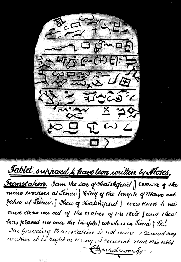
In Churchward’s Books of the Golden Age, published posthumously from his notes, there is an illustration of a tablet supposed to have been written by Moses - later duplicated. (click below image to enlarge)
The adopted son of an Egyptian princess who afterwards became Queen Hatshepsut, Moses became the high priest of an Osirian temple.
According to the Bible (Acts 7:22) Moses was instructed in the wisdom of the Egyptians. The Book of the Dead was a possible source for Moses’ spiritual teachings, as Cayce says this is its purpose (not a guide for mummified dignitaries), and dates from 5,000 BC or older (#706-1).
It is, says Churchward, Ezra’s translations into Hebrew which are (a small percent) inaccurate, made 800 years after Moses’ death, for Ezra upon returning from captivity in Babylonia was on hostile terms with the Egyptian priesthood, and had no grounding in Osirian religion or in the compound symbols used.
From Cayce.
Further corroboration of these travels was offered by Russian explorer Nicolas Notovich, who in the 1980s found accounts of "St. Issa" (the Buddhist name for Jesus) visiting India during the same time frame; he translated this from a Pali manuscript at the great monastery on Mt. Marbour, near Lhasa (written 200 years after Christ, brought from India to Tibet).
His Legend of St. Issa chronicles the tale, and a confirmation was provided by Swami Abhedananda in 1922, after viewing the mss. at Hernis, and writing Kashmiri O. Tibbetti. By the 1920s explorer Nicholas Roerich also reported viewing such records while touring Tibet.
The key to decoding all the world’s enigmatic scripts doubtless lies in proper translation of Maya, and its injection into other languages.
Establishing a computer base for all glyphs and symbols collected from ancient sites world-wide could be a first step in eventually finding a "Rosetta Stone" through technology. According to Churchward, the Japanese descended from Quiche Mayas of the sunken Mu, and are not related to Mongols; the Japanese language embodies 40% of Quiche Maya words.
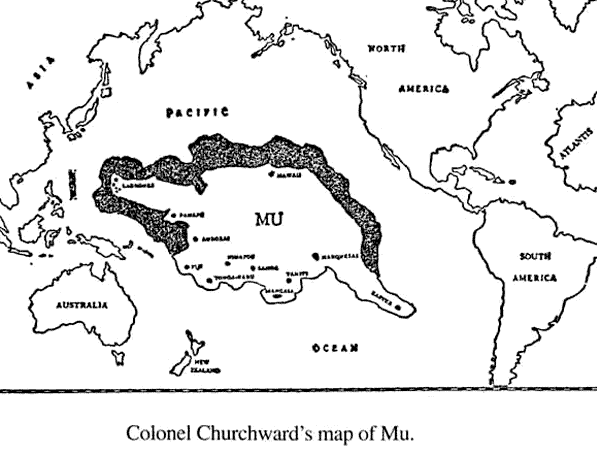
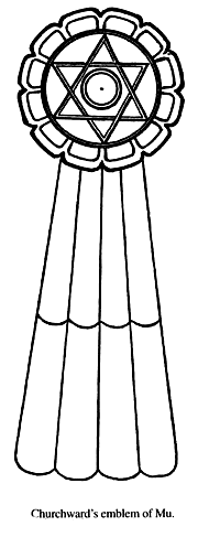
According to Japanese legends, "Kamiyo moji" or "shindai moji" (letters of the divine age) were the 2,400 different kinds of letters used by people of Mu, only inverted. Their flag is the emblem of Mu, Empire of the Sun, and many traditions have been passed down. According to Mahikari teachings in Japan (also called "Mioshie") which are based on Shintoism, Japan was once part of the continent of Mu, which stretched across the Pacific five or six thousand miles from east to west, and 3,000 miles north to south. Cayce puts its eastern boundary up near California, and adjoining the coast of Peru.
The ancient name for Japan, "Yamato," means "nation at the top of the pyramid."
Nothing could be more apt, for in the last five years important discoveries have been made at the bottom of the seafloor off Okinawa, near Yonaguni Island: a series of megalithic sites including stone terraces, pyramids, a town complex, castle, and temple structures, some 25 x 100 meters, and as much as 200 x 140 meters, in 100 ft. of water-including a fossil dated at 6,000 years by Nagoya University.
Eight sites were spotted, with coral encrusted stone walls and buildings, one topped by carved turtles.
The area hasn’t been above sea level in 8,000 years. They are definitely artificial, says Professor Masaaki Kimura of U. Of Ryukyus, who has studied Mu for 20 years with two books on the subject, noting that the architecture is similar to Machu Picchu and the Temple of the Sun near Trujillo, Peru. However, geologist Dr. Robert Schoch (who dived there in 1997) termed it a probable "terra formation," that is, naturally formed rock which had been worked by human hands. He visited only one of the eight sites, and not too thoroughly due to murky sea conditions. Other important ruins in the group that look more promising, Chatan and Kerama need investigation.
This has happened many times in the past. Cayce warned of,
backed up by the scientific evidence of anomalies in the earth’s "Chandler’s Wobble" that year, up to the present. Geologist William Hutton believes even a 9 degree sway from the axis norm would be enough to cause crustal displacement and geological events.
Cayce added,
Hutton has recently (Nov. 2001) stated that there is a good chance the auguries have started: higher incidence of quakes in the South Seas, activity in the Arctic and Antarctic (polar ice melting), increased volcanism in the torrid areas-all signs given by Cayce (#311-8, April, 1932 & #3976-15, January 1934).
And evidence exists, in the fused-glass (vitrified) streets in the ancient ruined cities of Harappa and Mohenjo-Daro, where radioactivity takes geiger counters to max readings.
This area is the present Pakistan, and excavations 100 years ago uncovered scattered skeletons stuck down unawares; clay vessels melted into black stones. Identical tales are told in the Drona Parva and the Bhagavad Gita, in Dravidian and Sanskrit, from which Dr. J. Robert Oppenheimer quoted, on watching his first atomic test in the 1940s.
Churchward describes the Maha Bharata version of the war as being between the Kavachas and the Pandavas. And Cayce refers to a war between Urlats (Ural-Altaics?) from the hills, and those of the plains, in which "explosives were used," in 1,097 BC (#2717-1 and #487-4). Pakistan is again an area of conflict, from without her borders, and the Khyber Pass to Afghanistan has always been a major escape route in battles. Perhaps it will he again.
In addition to the pursuit of the lost continent, Colonel Churchward opened the door to many topics that are only now being addressed.
More than a few of these are vital. Some should be re-investigated, like the Niven records - if possible, a repeat excavation in the area of his "thrice-buried cities," if urban development hasn’t covered it. The matter of South Pacific ruins, above and below ocean level, built with megalithic blocks from six islands away should be given the same deference as evidence in a court of law.
Explanations that include a sunken continent should be acceptable if they are the only ones that work! The Colonel was a remarkable man, and gained much entrée into high places through his connections as a Freemason. His time with the Rishi, even if but a few years, taught him many secrets of hypnotism, some of which he taught P.T., who demonstrated them often for my friends - not the usual parlor tricks.
And, one fact he did not mention to our family, was that he was in British Intelligence in India, which would explain the absence of certain records of James’ early background, especially military. This was revealed by Peter Tompkins (who had the information from unimpeachable sources) in his Mysteries of the Mexican Pyramids.
His birth certificate is dated 1851.
Images of the photocopied pages of original paper article HERE.
|

 In
1920, the British-horn Churchward came out with his first in a
series of five hooks, The Lost Continent of Mu, prefaced by an
admonition to "all scientists" to please copy for future reference.
important points of pre-history and anthropology he had compiled
through more than 50 years of research and exploration throughout
Asia and the South Sea:
In
1920, the British-horn Churchward came out with his first in a
series of five hooks, The Lost Continent of Mu, prefaced by an
admonition to "all scientists" to please copy for future reference.
important points of pre-history and anthropology he had compiled
through more than 50 years of research and exploration throughout
Asia and the South Sea: Whether Churchward intended to prime the pump for mega-controversy,
or whether he simply conveyed his findings, oblivious to any
repercussion-factor, didn’t matter.
Whether Churchward intended to prime the pump for mega-controversy,
or whether he simply conveyed his findings, oblivious to any
repercussion-factor, didn’t matter.
 Perhaps
Griffith (herein referred to as "P.T."), having known Churchward
since childhood, was the only person who really knew this genius
author, inventor, artist, engineer, geologist, expert angler,
psychic, and 33rd degree Mason.
Perhaps
Griffith (herein referred to as "P.T."), having known Churchward
since childhood, was the only person who really knew this genius
author, inventor, artist, engineer, geologist, expert angler,
psychic, and 33rd degree Mason.