|
Part 4 of 4
9. Sunken lands
... Easter Island – the living and solitary witness of a submerged prehistoric continent in
the midst of the Pacific Ocean.
– H.P. Blavatsky1
Read my lips: the islands of Polynesia are not, nor have they ever been, a part of a sunken
continent.
– A modern ‘expert’ 2
Easter Island lies some 500 km east of the crest of a submarine mountain range called the East
Pacific Rise; it is also situated on the Easter fracture zone.
The island is believed to be the summit of
an immense mountain formed by the outpouring of molten volcanic rock from the seafloor. It rests on
a submarine platform some 50 or 60 m below the ocean’s surface, but 15 to 30 km off the
coast, the platform ends and the ocean floor drops to between 1800 and 3600 m.
Easter Island owes its roughly triangular shape to the three volcanoes located at its corners:
Poike, Rano Kau, and Terevaka. In addition to these main volcanic centers there are at least 70
subsidiary eruptive centers. The oldest lava flows have been dated at up to 3 million years old, but
more recently lower dates of half to three-quarters of a million years have been published.3 Some scientists think the earliest lavas of Easter Island (now well below sea
level) erupted around 4.5 to 5 million years ago.4
Legend describes Easter Island as having once been part of a ‘much larger
country’. Successive ice ages during the Pleistocene have lowered sea level by at least 100
m and possibly far more at times, and Easter Island would then have been larger than it is today.
According to the ruling geological paradigm of plate tectonics, Easter Island has never been part of a
sunken continent.
However, the plate-tectonic model is challenged by a mountain of evidence. Some
of the main problems are outlined below.
|
 |
|
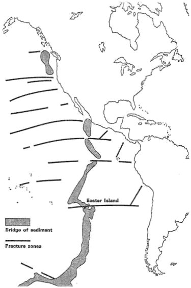
Fig. 9.1
Francis Mazière thought that the legendary lost continent of Hiva might have been a long continental ridge (the East Pacific Rise). As explained below, growing evidence is emerging that far larger areas of the Pacific Ocean were once land. |
Plate tectonics – a dogma in distress
Although most earth scientists jumped on the plate-tectonic bandwagon in the 1960s and 70s,
the theory has always had its critics. Their number is increasing as evidence contradicting the
reigning paradigm continues to accumulate.1
According to plate tectonics, the earth’s outermost layer, or lithosphere, is divided into
separate ‘plates’ that move with respect to one another on an underlying plastic layer known as the
asthenosphere. The lithosphere is said to average 70 km in thickness beneath oceans, and to be
100 to 250 km thick beneath continents. However, seismic tomography (which produces 3D images
of the earth’s interior) has shown that the oldest parts of the continents have very deep roots
extending to depths of 400 km or more, and that the asthenosphere is absent or very thin beneath
them.
Even under the oceans there is no continuous
asthenosphere, only disconnected
asthenospheric lenses. In addition, the boundaries of the main plates are sometimes ill defined or
nonexistent. These crucial facts – which go largely unmentioned in modern geological
textbooks – render the large-scale lateral movement of individual ‘plates’
impossible.
Plate tectonics claims that new ocean crust is constantly being created by upwelling magma at
‘midocean’ ridges (including the East Pacific Rise) and subducted back into the mantle
along ocean trenches, mostly located around the Pacific Rim. This would mean that the entire ocean
crust should be no more than about 200 million years old. Yet, although ignored by the textbooks,
literally thousands of rocks of Palaeozoic and Precambrian ages have been found in the
world’s oceans.
For instance, the rocks forming the St. Peter and Paul islands near
the crest of the Mid-Atlantic Ridge gave ages of 350, 450, 835 and 2000 million years, whereas
according to plate tectonics they should be only 35 million years old. Rocks from central Tahiti in the
South Pacific have proven to be over 800 million years old. Contrived and unconvincing attempts are
occasionally made to explain such anomalies away – e.g. as crustal blocks that somehow got
left behind during ‘seafloor spreading’.
Everyone accepts that enormous areas of the present continents have repeatedly been submerged beneath the sea; about 90% of
all the sedimentary rocks composing the continents
were laid down under water.
But due to their ingrained beliefs, plate tectonicists tend to ignore the growing evidence that there used to be large, now submerged,
continental landmasses in the present oceans – landmasses that are completely ignored in
imaginative reassemblies of today’s supposedly drifting continents. Several geoscientists
have called for a major effort to drill the ocean floor to much greater depths to verify whether, as the
data available already suggest, the basalt layer that is currently labeled ‘basement’
conceals more ancient sediments below it.2
The earthquakes taking place at different depths on the landward side of ocean trenches define
a
Benioff zone, which is interpreted in plate tectonics as a ‘descending plate’. How
ocean crust is supposed to descend into the denser mantle has never been satisfactorily explained.
Moreover,
Benioff zones have a highly variable and complex structure, with transverse as well as
vertical discontinuities and segmentation, and bear little resemblance to the highly stylized pictures
of continuous down-going slabs depicted in geological textbooks.
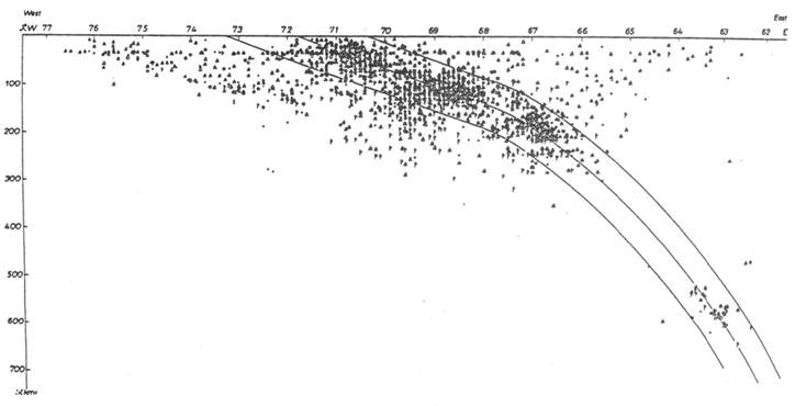
Fig. 9.2 Earthquake distribution perpendicular to the Andes (15-30°S).
The outlined ‘subducting slab’ appears to be a product of wishful thinking.3
The volume of crust generated at ocean ridges is supposed to be
equaled by the volume
subducted. But whereas 80,000 km of midocean ridges are supposedly producing new crust, there
are only 30,500 km of trenches and 9000 km of ‘collision zones’ – i.e. only half
the length of the ‘spreading centers’. If subduction was really happening, vast amounts
of oceanic sediments should have been scraped off the ocean floor and piled up against the
landward margin of the trenches.
However, sediments in the trenches are generally not present in
the volumes required, and they do not display the expected degree of deformation. Plate tectonicists
have had to resort to the far-fetched notion that soft ocean sediment can slide smoothly into a
subduction zone without leaving any significant trace.
An alternative view of
Benioff zones is that they are very ancient fractures produced by the
cooling and contraction of the earth, and currently represent the deformation interface between the
uplifting island arc/continental region and the subsiding ocean crust and mantle.
Most plate tectonicists believe that chains of oceanic islands and seamounts in the Pacific are
the result of the Pacific plate moving over ‘hotspots’ of upwelling magma. This should
give rise to a systematic age progression along hotspot trails, but a large majority show little or no
age progression. For instance, the ages of islands and seamounts along the Sala y Gomez ridge (on
which Easter Island and Sala y Gomez Island are located) fail to increase systematically to the
east.4
Hotspots are commonly attributed to ‘mantle
plumes’ rising from the core-mantle boundary. But critics have shown that plume
explanations are ad hoc, artificial, and inadequate, and that plumes are not required by any
geological evidence.5 An alternative proposal is that ocean island chains
are formed by magma that rises from much shallower depths, perhaps from a network of magma
‘surge channels’ in the lithosphere.
The continents and oceans are covered with a network of major structures or lineaments, many
dating from the Precambrian. In the Pacific basin there are intersecting megatrends, composed of
ridges, fracture zones, and seamount chains, running NNW-SSE and WSW-ENE (fig. 9.3).6
In plate tectonics, seamount chains supposedly indicate the direction of plate
movement, but to produce these orthogonal megatrends the plates would have to move in two
directions at once!
Although plate tectonicists invoke ad-hoc ‘microplates’ and
‘hotspots’ whenever the need arises, they are unable to offer a satisfactory
explanation of any of these megatrends, and prefer to ignore them.
Fig. 9.3 The Pacific ‘plate’.
Furthermore, some megatrends continue into the Australian, Asian, and North and
South American continents where they link up with major Precambrian lineaments, implying that the
‘oceanic’ crust is at least partly composed of Precambrian rocks – as has been
confirmed by deep-sea dredging, drilling, and seismic data. The Easter fracture zone lies on the
Central Pacific Megatrend, which spans the entire Pacific and continues across South America into
the Atlantic Ocean.7
These interconnecting lineaments demolish the
plate-tectonic myth that ‘plates’ and continents have moved thousands of
kilometers over the earth’s surface.
Sunken continents
It is commonly argued that Easter Island can never have formed part of a continent because no
granite or sedimentary rocks such as limestone and sandstone have ever been found there –
only igneous rocks.
But as
H.F. Blandford pointed out back in 1890:
[T]he occurrence of volcanic islands does not prove that the area in which they occur is not a
sunken continent. If Africa south of the Atlas subsided two thousand fathoms [3660 m], what would
remain above water? So far as our present knowledge goes, the remaining islands would consist of
four volcanic peaks – the Cameroons, Mount Kenia, Kilimanjaro, and ... Ruwenzori, together
with an island, or more than one, which, like the others, would be entirely composed of volcanic
rocks.
He added that there is ‘clear proof that some land-areas lying within continental limits
have within a comparatively recent date been submerged over a thousand fathoms, whilst
sea-bottoms now over a thousand fathoms deep must have been land in part of the
Tertiary’.1
Easter Island’s volcanic rocks consist mainly of basalts and andesites and a small
amount of rhyolite. Basalts are considered to be a major component of the ocean crust, but flood
basalts are also found in abundance on the continents. Furthermore, as more and more basalts are
analyzed, the difference in the composition of oceanic and continental flood basalts is becoming
increasingly blurred.2 In the plate-tectonic scheme, andesitic volcanoes
are supposed to form along the edge of a continent, above a mythical subduction zone.3
Easter Island of course now lies 3600 km from the nearest continent.
The coarse-grained equivalent of rhyolite is granite, which is found in abundance on the continents
– and increasingly under the oceans. Some geologists in the past have described Easter
Island’s rocks bluntly as ‘continental’.4
Plate-tectonicist
P.E. Baker puts it more cautiously:
‘the lavas in general are rather more
siliceous than is usual for an oceanic setting’; rocks from other islands on or near the East
Pacific Rise, such as Pitcairn and the Galapagos, are similar in this respect.5
Soviet scientist
N. Zhirov pointed out that ‘continental’ (sial) rocks such as
granite, schist, rhyolite, and/or andesite have been found on many Pacific islands, including the
Marquesas Islands, the Galapagos Islands, the Fiji Islands, the Tonga Islands, the Kermadec
Islands, Chatham, Bounty and Oakland Islands, and Chuuk, Yap, and Man Islands in the Carolines.
Most geologists nowadays prefer to assume that andesite and rhyolite rocks found in oceanic
settings formed by high levels of fractional crystallization of oceanic basalts – but this is
entirely hypothetical.6
Continental crust is usually said to average 35 km in thickness compared to only 7 km for
oceanic crust. The crust is 40 km thick beneath North Australia, 20 km thick in the eastern part of the
adjacent Coral Sea, 22-28 km thick in the Fiji-Tonga-Samoa area, and as much as 36 km thick at the
Tonga Islands.
There are over 100 submarine plateaus and ridges scattered throughout the oceans,
dotted with islands, and many may be submerged continental fragments that have not been
completely ‘oceanized’, as suggested by ‘anomalously’ thick crust and
finds of ‘impossibly’ ancient continental rocks.
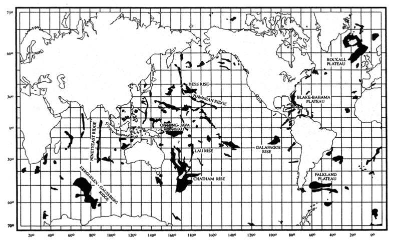
Fig. 9.4 Worldwide distribution of oceanic plateaus (black).
In the early 20th century, geologist
J.W. Gregory concluded from a detailed survey of geological
and palaeontological evidence that landmasses of varying sizes had been uplifted and submerged at
various times in the Atlantic and Pacific oceans, most of them disappearing by the Miocene.
He
wrote:
‘The direct geological evidence is overwhelming, that large blocks of the Earth’s
crust rise and fall for vertical amounts greater than the greatest depths in the oceans.’7
Russian geoscientist
E.M. Ruditch concluded from a detailed study of ocean drilling results that
there is no systematic correlation between the age of shallow-water sediments and their distance
from the axes of the midoceanic ridges. This disproves the seafloor-spreading model, according to
which the age of sediments should become progressively older with increasing distance from the
midoceanic ridge.
Some areas of the oceans appear to have undergone continuous subsidence,
whereas others have experienced alternating episodes of subsidence and elevation. He believed
that major areas of the oceans were formerly land. The Pacific Ocean appears to have formed
mainly from the late Jurassic to the Miocene, the Atlantic Ocean from the Late Cretaceous to the end
of the Eocene, and the Indian Ocean during the Paleocene and Eocene.8
This corresponds closely to the theosophical teachings on the submergence
of Lemuria in the Late Mesozoic and early Cenozoic, and the submergence of
Atlantis in the first half
of the Cenozoic.9
Fig. 9.5
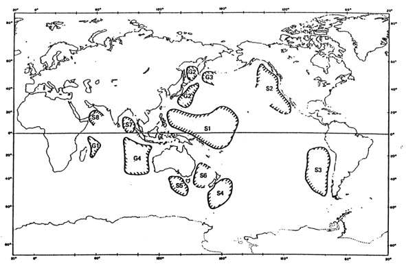
The map of former land areas in the present Pacific and Indian Oceans presented in fig. 9.5 was
compiled by geoscientists J.M. Dickins and D.R. Choi on the basis of ocean-floor sampling and drilling, seismic data, and the location of ancient sediment sources.10 Only landmasses for which substantial evidence already exists are shown, but their exact outlines and full extent
are as yet unknown.
Some geologists have argued that the area in the Southeast Pacific
labeled S3
probably extended much further west and encompassed what is now Easter Island.11
Lost Pacific islands
Easter Island legends tell of the first settlers arriving after their native land had been
submerged, and of a giant named Uoke, in a fit of anger, causing the subsidence of a large
continent, of which Easter Island is a remnant. Similar traditions of vanished continents are found
throughout Polynesia and Melanesia, and in other areas bordering the Pacific.
For instance, the
Hawaiians believed there was once a great continent stretching from Hawaii to New Zealand, but it
sank, leaving only its mountaintops as islands. Such legends do not specify when the various
landmasses are supposed to have existed. Although it is certain that no large continents in the
Pacific have been submerged during the past few millennia, several writers believe that islands of
reasonable size have done so.
When the Dutchman
Roggeveen discovered Easter Island in 1722, he was actually searching
for Davis Land. An English buccaneer named John Davis reported sighting this island in 1687 in
latitude 27°20'S. He said it was 800 km from the coast of Chile, low, flat, and sandy, but
with ‘a long tract of pretty high land’ to the northwest. This description in no way
applies to Easter Island. The general belief today is that Davis had misjudged his position, as was by
no means unusual in the case of the early mariners, and that Davis Land was
Mangareva, the chief
island in the Gambier archipelago, far to the west of Easter Island.
However, in the early 20th century
Lewis Spence and John Macmillan Brown took the report of
Davis Land at face value, and concluded that an archipelago of considerable extent must have
foundered in this area between 1687 and 1722. Brown thought that Sala y Gomez, a rocky islet just
above water some 415 km northeast of Easter Island, was probably the remains of Davis Land; there
are numerous reefs around it and the water in its vicinity is shallow.1
The
Easter Islanders called it Motu Matiro Hiva, meaning ‘islet in front of Hiva’, Hiva being
the name given to their legendary homeland.
In addition to the Easter Island archipelago, Spence and Brown argued that land had also been
submerged in several other parts of the Pacific within the last few thousand years.2
They held, for instance, that the Caroline archipelago could be the remains
of a vast island-empire in the eastern Central Pacific. The ruins of Nan Madol on
Pohnpei, with its
massive walls, earthworks, and great temples, intersected by miles of artificial
waterways, would have required a workforce of tens of thousands (see section 10
below). Brown pointed
out that within a radius of 2400 km there are no more than 50,000 people today, and added:
‘It is one of the miracles of the Pacific unless we assume a subsidence of twenty times as
much land as now exists.’3
On the little coral island of Woleai,
some 1600 km west of Pohnpei, he found a written script still in use, quite unlike any other in the
world (see
section 7).
Quite a few islands that mariners have reported on their travels have later gone
missing.4
-
For instance, in 1879 an Italian captain announced his discovery of
Podesta
Island, just over a kilometer in circumference, 1390 km due west of Valparaiso, Chile. The island has
not been found since, and was removed from charts in 1935.
-
An island near Easter Island was
sighted in 1912 but was likewise never seen again.
-
Sarah Ann Island northwest of Easter Island was
removed from naval charts when a search in 1932 failed to find it. The need for caution in
interpreting such accounts is underlined by the following incident.
-
In 1928 the captain and two
officers on a British luxury liner announced that Easter Island itself had vanished! A Chilean gunboat
was sent to the island and found it in its usual place.
-
In 1955 US military pilots sighted an island 615 km west of Honolulu, but it disappeared within a
few weeks, leaving only sulphurous streaks on the surface.
-
In February 1946, a British warship
witnessed the birth of two volcanic cones 320 km south of Tokyo; they rose to a height of 15 m and
spread out over an area of about 2.5 sq km.
-
Two months later they had dissolved into a shoal
considerably larger than their initial size. In addition to temporary volcanic islands that suddenly
appear in deep ocean basins, there are also islands that rise and fall in more shallow regions.
-
Fonuafo’ou (Falcon Island) in the Tonga group, was born in 1885 when an eruption raised a
shoal 88 m above the ocean surface. Over the next 13 years, its 3-km-diameter mass disappeared.
It was reborn in 1927, and today is about 30 m high.
-
Metis Island, 120 km from Fonuafo’ou,
popped up in 1875 and vanished in 1899.
-
Hunter Island was discovered in 1823 at 15°31'S and 176°11'W. It was
a fertile land, inhabited by cultivated Polynesians who had the curious custom of amputating the little
finger of the left hand at the second joint. But the island was never seen again.
-
The three Tuanaki
Islands, part of the Cook group in the South Pacific, disappeared around the middle of the 19th
century. These islands, too, were inhabited by Polynesians, but in 1844 a missionary ship failed to
locate them. Several former inhabitants of the islands, who had left in their youth, died in Rarotonga
during the 20th century.
Although a few small islands seem to have sunk in the Pacific in the past few millennia, the
evidence that archipelagoes on the scale that Spence and Brown had in mind existed during this
period is extremely slim.
But, as explained above, landmasses of continental size undoubtedly
existed in the Pacific in the much more distant past.
References
-
H.P. Blavatsky Collected Writings (vols. 1-14), Wheaton, IL: Theosophical
Publishing House, 1950-85, 7:292-3.
-
www.islandheritage.org/mysteries.html.
-
K.M. Hasse, P. Stoffers and C.D. Garbe-Schönberg, ‘The petrogenetic evolution of
lavas from Easter Island and neighbouring seamounts, near-ridge hotspot volcanoes in the SE
Pacific’, Journal of Petrology, vol. 38, no. 6, 1997, pp. 785-813.
-
R.I. Rusby, ‘GLORIA and other geophysical studies of the tectonic pattern and history of
the Easter Microplate, southeast Pacific’, in: L.M. Parson, B.J. Murton and P. Browning (eds.),
Ophiolites and their Modern Oceanic Analogues, London: Geological Society Special
Publication no. 60, 1992, pp. 81-106 (p. 101).
Plate tectonics – a dogma in distress
-
See ‘Plate tectonics: a paradigm under
threat’, and ‘Sunken continents versus
continental drift’, http://ourworld.compuserve.com/homepages/dp5 (Earth
science).
-
J.M. Dickins, D.R. Choi and A.N. Yeates, ‘Past distribution of oceans and
continents’, in: S. Chatterjee and N. Hotton III (eds.), New Concepts in Global
Tectonics, Lubbock, TX: Texas Tech University Press, 1992, pp. 193-9.
-
See ‘Problems with plate tectonics’,
http://ourworld.compuserve.com/homepages/dp5/lowman.htm.
-
J.G. Clark and J. Dymond, ‘Geochronology and petrochemistry of Easter and Sala y
Gomez Islands: implications for the origin of the Sala y Gomez Ridge’, Journal of
Volcanology and Geothermal Research, vol. 2, 1977, pp. 29-48.
-
H.C. Sheth, ‘Flood basalts and large igneous provinces from deep mantle plumes: fact,
fiction, and fallacy’, Tectonophysics, vol. 311, 1999, pp. 1-29.
-
N.C. Smoot, ‘Magma floods, microplates, and orthogonal intersections’,
New Concepts in Global Tectonics Newsletter, no. 5, 1997, pp. 8-13.
-
N.C. Smoot, ‘Earth geodynamic hypotheses updated’, Journal of Scientific
Exploration, vol. 15, no. 4, 2001, pp. 465-94.
Sunken continents
-
Quoted in Lewis Spence, The Problem of Atlantis, London: William Rider &
Son, 1924, pp. 34-5.
-
A.A. Meyerhoff, I. Taner, A.E.L. Morris, W.B. Agocs, M. Kaymen-Kaye, M.I. Bhat, N.C. Smoot
and D.R. Choi, Surge Tectonics: A new hypothesis of global geodynamics (D. Meyerhoff
Hull, ed.). Dordrecht: Kluwer, 1996, pp. 192-3.
-
D. McGeary and C.C. Plummer, Physical Geology: Earth revealed, Boston, MA:
WCB, McGraw-Hill, 3rd ed., 1998, pp. 170, 266.
-
P.L. Lyons, ‘Continental and oceanic geophysics’, in: H. Johnson and B.L.
Smith (eds.), The Megatectonics of Continents and Oceans, New Brunswick, NJ: Rutgers
Univ. Press, 1970, pp. 147-66 (p. 162).
-
P.E. Baker, ‘Preliminary account of recent geological investigations on Easter
Island’, Geology Magazine, vol. 104, no. 2, 1967, pp. 116-22.
-
N. Zhirov, Atlantis. Atlantology: basic problems, Honolulu, HA: University Press of
the Pacific, 2001 (1970), pp. 150-1.
-
J.W. Gregory, ‘The geological history of the Pacific Ocean’, Quarterly
Journal of Geological Society, vol. 86, 1930, pp. 72-136 (p. 132).
-
E.M. Ruditch, ‘The world ocean without spreading’, in: A. Barto-Kyriakidis (ed.),
Critical Aspects of the Plate Tectonics Theory, Athens: Theophrastus Publications, 1990,
vol. 2, pp. 343-95.
-
See ‘Theosophy and the seven
continents’, http://ourworld.compuserve.com/homepages/dp5/continents.htm.
-
J.M. Dickins, ‘What is Pangaea?’, in: A.F. Embry, B. Beauchamp and D.G.
Glass, Pangea: Global environments and resources, Canadian Society of Petroleum
Geologists, Memoir 17, 1994, pp. 67-80; D.R. Choi, ‘Geology of the southeast Pacific’,
parts 1-3, New Concepts in Global Tectonics Newsletter, no. 7, pp. 11-15; no. 8, pp.
8-13; no. 9, pp. 12-14, 1998.
-
L.S. Dillon, ‘Neovolcanism: a proposed replacement for the concepts of plate tectonics
and continental drift’, in: C.F. Kahle (ed.), Plate Tectonics – Assessments and
Reassessments, Memoir 23, Tulsa, OK: American Association of Petroleum Geologists, 1974,
pp. 167-239 (p. 222); Zhirov, Atlantis, pp. 154-5.
Lost Pacific islands
-
John Macmillan Brown, The Riddle of the Pacific, Kempton, IL: Adventures
Unlimited, 1996 (1924), p. 45.
-
Lewis Spence, The Problem of Lemuria, Kila, MT: Kessinger, n.d. (1933), p. 143.
-
The Riddle of the Pacific, p. 52.
-
Vincent Gaddis, Invisible Horizons, New York: Ace Books, 1965, pp. 25-47.
Back to Contents
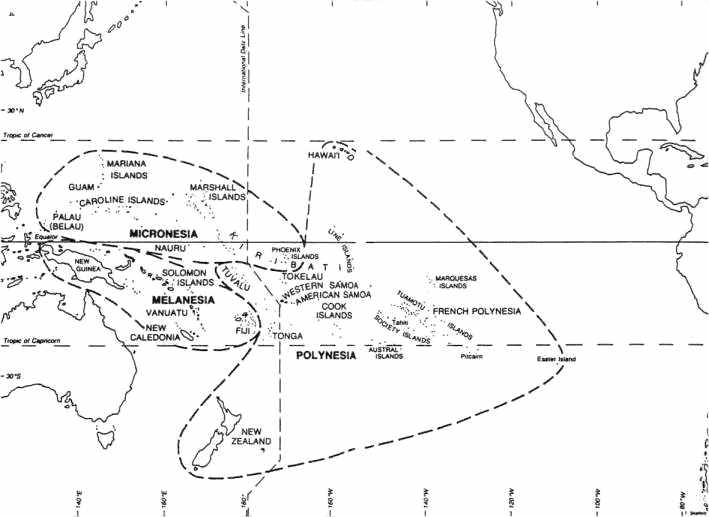
Fig. 10.1 The Pacific Ocean and its islands.
The settlement of the Pacific is currently thought to have begun some 50,000 years ago, when
hunter-gatherers first colonized Australia and New Guinea in the western Pacific, at a time
when they were joined by land due to the lower sea level resulting from the ice age. Migration
proceeded eastwards, and reached the northern Solomon Islands about 28,000 years ago.
The Polynesian islands are believed to have been settled for the first time only within the last 2000
years or so, because the Polynesians took a long time to develop the navigational
expertise enabling them to sail far offshore. However, dates for the settlement of the various Pacific
islands are very tentative since they are based mainly on the oldest radiocarbon dates so far
obtained; future discoveries may indicate that human habitation goes back countless millennia
earlier.
The history of even the past few thousand years is as yet poorly known. For instance, despite
persistent denials by many orthodox archaeologists, there is growing evidence for transatlantic and
transpacific contacts between a variety of ancient cultures, including the Egyptians, Libyans,
Phoenicians, Greeks, Arabs, Hindus, Dravidians, Chinese, Mayans and Incas.1
Some ancient maps provide tantalizing but controversial evidence that the
earth had been mapped over 10,000 years ago, during the last ice age.2
There may have been several waves of migration into the Pacific from different directions, and over
a time-span far vaster than mainstream archaeologists are willing to contemplate.
The origin of the Polynesians has also been the subject of controversy. The prevailing theory in
the late 1800s and early 1900s was that the Polynesians were an Indo-European group who came to
the Pacific via India. Nowadays they are generally believed to have come partly from Northeast Asia
and also from the Malay archipelago.
But as
Graeme Kearsley says:
they are in many respects closely allied to Caucasians and were in many studies considered
as such, and this racial heritage is still obvious in many islands in Eastern Polynesia as it was to the
first European explorers. These migrations followed the same pattern as land migrations in that the
male migrants, or mariners, traded, bought or captured marriage partners from coastal or island
peoples thereby producing mixed race descendants. Therefore variable racial inheritance is clearly
in evidence throughout the islands of the Pacific ...
In almost all of
the reports by the first Europeans there are references to the variable skin
coloring of Polynesians
on different islands, but also within the people of one island.
Some Polynesians appeared to be Indians of the Americas, while others were of
‘Jewish’ type or wore turbans.
Kearsley argues that there were trade links and cultural
transfers from Asia, India, and the Middle East across the Pacific to South America, and at least a
few contacts from South America across the Pacific back to Asia, with the result that the Andean and
Peruvian cultures greatly influenced the Polynesians.3
*
* H.P. Blavatsky has the following to say about the Polynesians: ‘there is
in the Malay race (a sub-race of the Fourth Root Race) a singular diversity of stature; the members
of the Polynesian family (Tahitians, Samoans, and Tonga islanders) are of a higher stature
than the rest of mankind; but the Indian tribes and the inhabitants of the Indo-Chinese
countries are decidedly below the general average. This is easily explained. The Polynesians belong
to the very earliest of the surviving sub-races, the others to the very last and transitory
stock.’4
The following brief tour of the Pacific focuses on remains of monumental and megalithic
architecture. As on Easter Island, some of the structures may be the work of very ancient and
as-yet-unknown cultures.
Micronesia
In the mid-1980s a rectangular stone structure, measuring about 250 m long, 100 m wide, and
25 m high, was discovered off the small Japanese island of
Yonaguni. It now lies
in depths of up to 30 m of water but would have been exposed about 10,000 years, when the sea level
was much lower, at which time it would have stood on the tropic of Cancer. The structure includes
wide terraces, large steps, ramps and trenches, and two megalithic blocks 6 m high, about 2.5 m
wide, and 4.9 m thick.
Some of the stones show tool marks, and it seems likely that the structure is a
natural geological formation that has been worked and modified by human hands.1
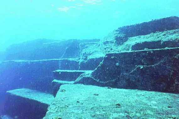
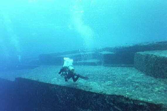
Fig. 10.2
Submerged structure near Yonaguni.2
Other sunken structures have been found over a distance of 500 km between Yonaguni and
Okinawa. They include paved streets and crossroads, huge altar-like formations, grand staircases
leading to broad plazas, and processional ways surmounted by pairs of towering features resembling
pylons.3
Throughout the
Mariana Islands latte stones are found – tall stone
columns with a hemispherical capstone, looking like mushrooms. The upright stones usually occur in
double rows of 6 to 14 stones. Latte stones range from small crude structures constructed of natural
boulders to massive stone columns, square in shape, 4.5 m or more in height, capped with
enormous blocks of stone.
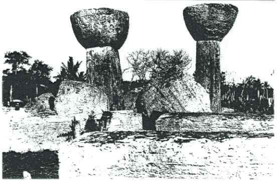
The island of Tinian has two of the largest standing megaliths. The pillars
are 5.5 m in circumference at the base and 4.5 m at the top. They are 3.7 m high and support
capitals 1.5 m high and 1.8 m in diameter. Each coral monolith weighs about 30 tons.
There were
originally 10 pillars arranged in two parallel rows, known as the House of Taga.4
Fig. 10.3 House of Taga, Tinian.
When the Spaniards first arrived in the early 16th century, the lattes were already partly in ruins.
The natives (descendants of the ancient Chamorros) disclaimed all knowledge of the builders, and
ascribed the stones to the ‘spirits of the before-time people’. Since the natives called
them the ‘houses of the old people’ and still build their houses on supports, it is
commonly assumed that the lattes once supported wooden houses, though no one has ever seen
them used for that purpose.
Another view is that the taller lattes once supported the roof of ancient
temples, as in the
Temple of Luxor at Karnak, Egypt.
The marked differences in the shape, size, and quality of the lattes suggest that they could
have been made by different cultures at widely different times. The earliest radiocarbon date from
organic material found in the vicinity of the lattes is 900 AD – but this tells us nothing about
when they were made. In 1949 two pieces of iron were discovered under the base of one latte pillar.
These pieces of iron were not intrusive, and some archaeologists have concluded that at least one
latte stone must have been erected after the arrival of the Spaniards
– the possibility that earlier cultures on the island may have used iron is ruled
out on ideological grounds.5
Pohnpei (or Ponape, also called Ascension) is a volcanic island in the eastern
Caroline
Islands, and may have been the centre of a vanished empire. In the lagoon on the
southeastern coast of Pohnpei lies Nan Madol, the ‘Venice of the Pacific’. It covers
more than 18 square kilometers, but the core of the site is about 1.5 km by 0.5 km and contains 92
artificial islands built in the lagoon and surrounded by man-made canals. The islands were made by
stacking large undressed hexagonal basalt prisms, most weighing under 10 tons, on the coral reef
and filling in the centre of the islet with coral.
The buildings are rather crude, but the scale of the work
is very impressive. The largest structure, Nan Douwas, oriented to the cardinal directions, consists of
two concentric perimeter walls separated by a seawater moat and enclosing a central pyramidal
mound. The walls are made from basalt megaliths over 6 m long and reach 7.6 m in height, but
could have been far higher originally.
The largest stone, a massive basalt cornerstone on the
southeast side of Nan Douwas, weighs around 50 tons.
Fig. 10.4 Nan Douwas.6
Between 500 and 750 thousand tonnes of building material were transported from varying
distances to the site. Although legend speaks of the prisms being magically floated through the air,
the official view is that they were carried on coconut palm rafts. Lost prisms can in fact be seen on
the bottom of the lagoons along the route from the quarries, indicating that at least some were transported by this means.
Ashes at the bottom of a fire pit on one of the artificial islands were
dated to 1000 AD, but this only shows that the city was inhabited at that time – not that the
entire city was built then. In any event, traces of an earlier layer of construction have also been
detected.
According to legend, two wise and holy men, Olosopa and Olosipa, selected the site of
Nan Madol after they climbed a high peak and saw an underwater city below; Nan Madol was built as a
‘mirror image’ of its sunken counterpart. Legend speaks of two sunken cities and of
underwater tunnels. The existence of extensive undersea ruins has been confirmed. They include a
series of tall pillars standing on flat pedestals, reaching heights of up to 8 m.7
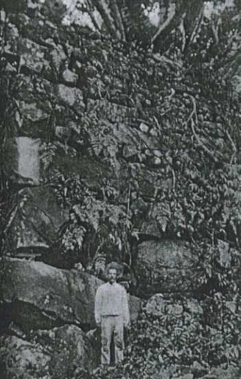
The ancient giant stone city of Insaru on Lelu Island, which lies adjacent to Kosrae (the
easternmost of the Carolines), was also made of huge basalt walls and pyramids, with the islands
and buildings being intersected by a canal network connected with the ocean. The ruins are very
similar to those of Nan Madol but not as extensive. Some of the walls are over 6 m high, and the
megalithic basalt blocks weigh up to 50 tons. Whereas Nan Madol has sunk somewhat, Lelu
appears to have risen slightly since the canals are almost dry.
Where the stones came from is a
mystery; legend says the city was built in one night by two magicians.
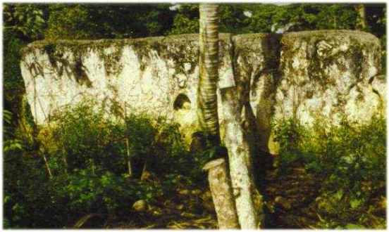
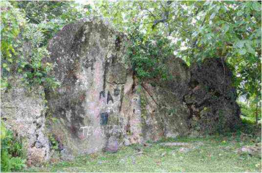
Fig. 10.5 Rare 1899 photo of one of the massive walls on Lelu Island.8
On the Palau islands, the westernmost of the Carolines, over 5% of the land surface is terraced,
and whole hills have been sculpted to resemble step pyramids. Some of the terraces are 4.5 m or
more high and often 9 to 18 m wide. The terraces do not feature at all in local oral traditions, and no
one knows who built them. The Bairulchan megalithic site on Babeldaob has two rows of large basalt
monoliths, some with facial features carved on them.
There are 37 stones in all, some weighing up to
5 tons, and the largest being 3 m tall. Similar monoliths can be found on Vao and Malekula in the
Vanuata Islands (New Hebrides).
Fig. 10.6 Part of a broken monolith on Malekula.9
Melanesia
On the Isle of Pines in
New Caledonia there are about 400 large tumuli or
mounds, ranging from 9 to 50 m in diameter, and 0.6 to 4.6 m in height. The material composing
them seems to come from the immediate surroundings: coral debris, earth, and grains of iron oxide.
The larger tumuli enclose cement columns of lime and shell matter, suggesting that the tumuli are
the product of human activity. Many archaeologists doubt this as the early settlers did not use
cement, and they theorize that the mounds were built by huge, now-extinct, flightless birds for
incubating their eggs!
However the cylinders inside the tumuli are of a very hard, homogeneous
lime-mortar, containing bits of shells which have yielded radiocarbon dates of 5120 to 10,950 BC;
even the later date is some 3000 years earlier than humans are believed to have reached the southwest
Pacific from the Indonesian area.1
Polynesia
The Polynesian triangle stretches from New Zealand in the southwest to Hawaii in the north to
Easter Island in the southeast. Nowhere in the Pacific are there as many impressive megalithic
remains concentrated in so small an area as on Easter Island. Nevertheless, there are several
notable structures on other islands.
The island of Tongatapu in the
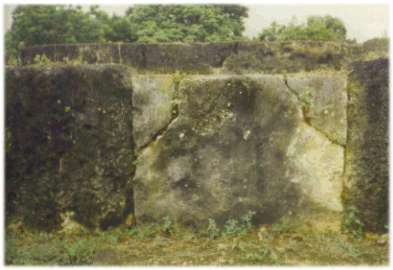
Tonga Islands has the only megalithic arch in
the South Pacific – the trilithon of Ha’amonga. Each of the upright coral pillars is 4.9 m
high and weighs about 50 tons. The lintel, which is set into grooves in the upright stones, is 5.8 m
long and weighs about 9 tons.
One theory is that the trilithon was erected in the 14th century for
a king to sit on as he drank an alcoholic beverage known as kava!
Fig. 10.7 The trilithon of Ha’amonga.1
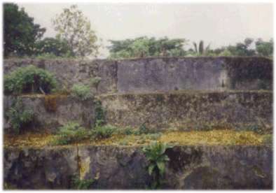
The ceremonial centre of Mu’a (formerly Lapaha), a canal city on Tongatapu, has many
megalithic platforms (known as langi). The central area of Mu’a was surrounded
by a huge canal or moat. Massive rocks at an ancient port on the lagoon side of Mu’a indicate that huge vessels once docked there.
The island has risen about a
meter over the last few
thousand years and such structures as the wharf and canal/moat are now useless.
Langi Tauhala, a
pyramidal platform at the old fortress of Tongatapu, is made of massive cut stone blocks.
It contains
probably the largest structural stone ever used by the Polynesians: measuring 7.4 m long, 2.2 m
high, 0.4 m thick, and weighing 30 to 40 tonnes, it is notched and fitted into an adjacent block,
and forms part of a wall 222 m long.
Fig. 10.8 The largest stone block in Langi Tauhala, Mu’a.
The
unusual notching can be seen on the far right.2
Fig. 10.9 Other stonework at Lapaha.
On the basis of carbon-dating, Samoa is believed to have been settled by
the Lapita people around 1200 BC, at about the same time as Tonga. On Savai’i island is an
enormous flat-topped mound of stone blocks, known as the Pulemelei – the largest surviving
mound in Polynesia. It covers 61 by 50 m at the base, and rises in two tiers to a height of over 12 m.
At either end is a slightly sunken ramp to the top, together with a pavement, and it is surrounded by
numerous other platforms, roads, and stone walls, as would befit a major ceremonial centre. On
Upolu is another ceremonial centre consisting of immense earthen mounds, seven of which are
truncated, rectangular pyramids. The largest of them surpasses the Pulemelei in size: it is 105.5 by
95.8 m at its base, about 12.2 m high, and appears to be made entirely of earth.
The mounds are
generally thought to have been used for the former royal amusement of pigeon-snaring, but it seems
unlikely that this was their original purpose.
Fig. 10.10 The Pulemelei mound (left) and a star-shaped mound (right) on
Savai’i, Samoa.3
Malden Island (one of the Line Islands, Republic of Kiribati
[pronounced: Kiribas]), now uninhabited, has some 40 stepped pyramidal platform-temples, 3 to 9 m
high, 6 to 18 m wide, and 27 to 60 m long, with traces of paved roads leading down to the sea.4
On
Rarotonga, the largest of the Cook Islands, piercing the ears and
extending the earlobes were old customs, as was the case on Easter Island, in ancient India, and in
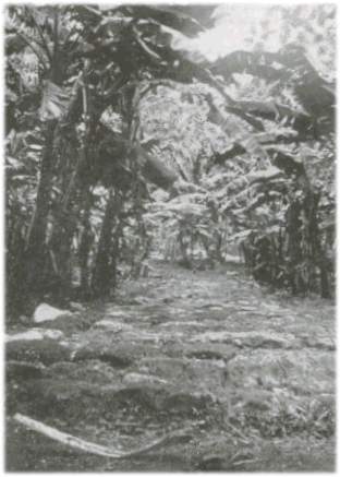
Peru. The Rarotonga dialect is close to the Rapanui language. The island has a megalithic road that
once encircled the entire island, as well as several pyramidal platforms.
Some sections of the road
were paved with perfectly fitting slabs, but most of it has now been paved over with asphalt. The
kerbing is composed of neatly fitted blocks of prismatic basalt laid closely together. It is better
constructed than the roads on Malden Island, and similar to those found in Peru.
Rectangular
enclosures associated with ceremonial platforms are set off from road.
Fig. 10.11 Paved road encircling Rarotonga.5
Truncated, pyramidal platforms, or marae, are found throughout the
Society Islands, some consisting of megalithic stones, carefully shaped and fitted.
The largest of all the Polynesian stone structures was Marae Mahaiatea on Tahiti. In overall
appearance it was a stepped pyramid with a broad flat top. It measured 21.6 by 81.4 m at the base,
and rose in 11 steps to a height of over 13 m.
The courses were made of coral blocks, faced with
squared volcanic stones. It is said to have been completed shortly before Captain Cook’s visit
in 1769, but was demolished after 1897.
Fig. 10.12 Marae Mahaiatea.6
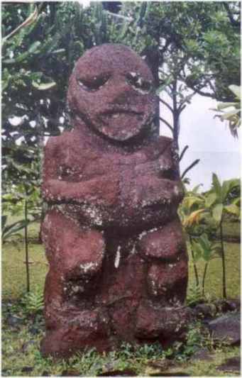
Fig. 10.13 The largest tiki found in Polynesia. It stands 2.75 m (9 ft) tall, and
consists of 2 tons of basalt. It was carved on Raivavae (one of the Austral Islands), the religious centre of Polynesia, but now stands at Tahiti’s Gauguin Museum.
Claims that the moai statues of Easter Island are a development of the Polynesian tiki are
unconvincing.
Fig. 10.14 On the remote island of Rapa – also known as Rapa Iti
(Little Rapa) to distinguish it from Rapa Nui (Big Rapa, i.e. Easter Island) – the hills are
carved with overgrown terraces and mysterious pyramids; it is not known who made them.7
Marae Taputapuatea on Raiatea (the largest of the Leeward Islands) is 43 m long, 7.3 m wide, and up to 3.7 m high. It is thought to have been erected in the
early part of the 2nd millennium AD, but was built over an older platform. It is one of the largest and
best preserved platforms in Polynesia, and one of its most sacred sites.
Like those of Raiatea, the
marae on Huahine and Bora Bora are constructed of large coral slabs, whereas comparable
structures on Tahiti and Moorea are made of round basalt stones.
Fig. 10.15 Coral slabs in Marae Taputapuatea.
Fig. 10.16 Coral slabs in Marae Tainuu, Raiatea.
Throughout the
Marquesas Islands the remains of great stone platforms,
walled house sites, and terraces, most of them overgrown with jungle vegetation, provide silent
testimony of a vanished culture. The largest archaeological site in Polynesia is found on
Hiva Oa,
and occupies the whole of the Taaoa Valley. This partially restored site has over 1000
paepae (platforms on which houses were built), a large tohua (public
ceremonial centre), and several me’ae (sacred platforms taboo to the public).
Some of the platforms are 120 m long and 30 m wide, and contain cyclopean basalt blocks weighing
over 10 tons. However, no carefully cut stonework comparable to Ahu Vinapu on Easter Island has
been found.
Fig. 10.17 Platform in the Taaoa Valley.
Fig. 10.18 On the massive Te I’ipona me’ae at
Puama’u on Hiva Oa stand
five
huge stone tiki, the largest being 2.43 m tall.
One of the most impressive archaeological sites is the unrestored ancient ceremonial centre in
the Taipivai Valley on Nuku Hiva. It includes a massive platform, Vahangeku’a Tohua, built
on an artificial terrace on a hillside.
Measuring 170 by 25 m, it contains an estimated 6800 cubic
meters of earth fill, and was faced by a wall almost 3 m high consisting of enormous basalt blocks,
some of them 1.5 m high and just as broad.
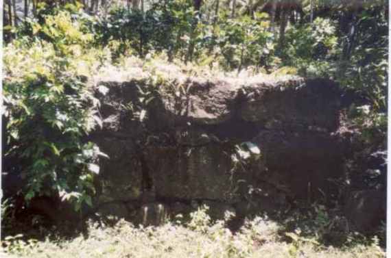
Fig. 10.19 Megalithic 3-m-high wall of Vahangeku’a Tohua, Nuku
Hiva.
In 1956 archaeologist
Robert Suggs carried out excavations at Hikouku’a in the Hatiheu
Valley on Nuku Hiva, a sacred site that had long been concealed from western visitors. His crew dug
several trenches in the huge platform in the hope of finding datable artifacts. Their finds included a
musket used in the American Civil War, a French brandy bottle, and a glass bowl manufactured in
Philadelphia in the late 1700s.
Suggs concluded that the platforms had been constructed
since the arrival of the Europeans in the Marquesas.
However, novelist
Herman Melville had visited Nuku Hiva in 1842, and described the massive
platforms as being of such antiquity that his Marquesan guide said they were ‘coeval with the
creation of the world’. Melville’s book on the subject appeared in 1846, 15 years
before the American Civil War. Yet Suggs believed the platforms were still being constructed in the
mid-1800s! He had fallen into the common error of assuming that the dates of artifacts or burials
found in association with megalithic structures are reliable indicators of when the original structure
was built.8
The structures could of course be thousands of years older,
and could have been renovated, rebuilt, or enlarged several times.
Nowadays the Marquesas Islands have about 8000 inhabitants. The population is thought to
have peaked at about 100,000 a few centuries ago, but was decimated following the arrival of the
Europeans at the end of the 16th century.
The Marquesas are frequently assumed to have been
settled by people of western Polynesian origin, probably from Tonga or Samoa, around 300 AD, but
Suggs argues that they were settled much earlier, around 300-500 BC. The islands are widely
believed to have been one of the main points from which Polynesians spread throughout the Pacific;
the Marquesan language is closely related to the languages of Hawaii, Mangareva, and Easter
Island.
A minority view is that the Marquesas were populated from Mexico or Peru, but
opponents point out that no South American pottery or tools have ever been found in Polynesia.
Nevertheless, there is evidence that the Marquesas, as one of the most easterly parts of Polynesia,
played a key role in two-way contacts between Asia and the Americas. There are many cultural
parallels between the Marquesas and the cultures of Mexico, Colombia, Ecuador, Peru, and Bolivia.
For instance, ear elongation was
practiced in the Marquesas, as it was in Peru. The
Marquesans also practiced skull elongation, a custom found in Peru and also among the Flathead
Indians of Montana. Bug-eyed statues similar to those found on the Marquesas are found in Bolivia
and Peru, especially at Tiahuanaco and Chavin, and they have also been compared to Chinese
Bronze Age statues. The ancient sacred centre of Nuku Hiva was probably the Taipivai Valley, which
lies next to the sacred mountain of Taipi. Interestingly, the sacred centre at Tiahuanaco bears a
similar name: Taypi.
Near the temple platforms on
Nuku Hiva, and on certain other Polynesian islands,
sacred banyans were grown; banyans can also be seen growing from stone platforms in
India.9
World grid
Many ancient cultures were familiar with the important astronomical cycle known as the
precession of the equinoxes.1 Due to a very slow gyration of the
earth’s axis, the spring equinox occurs about 20 minutes earlier every year, and the rising sun
moves slowly against the backdrop of the zodiacal constellations from one equinox to the next, at an
average rate of 1/72 degree per year. It therefore moves 1° in 72 years, 30° (one
constellation of the zodiac) in 2160 years, and takes 25,920 years to make a complete circuit of the
zodiac.2
Numbers such as 54, 72, 108, 144, and 180 (all multiples of 18)
are known as precessional numbers, and were assigned special significance in ancient societies.
As
Graham Hancock has pointed out, if we take the meridian of Giza-Heliopolis in Egypt as the
zero-meridian for measuring longitude, we find that the great temple complex of Angkor Wat in
Cambodia lies 72° east of the Giza meridian, the ruins of Nan Madol on Pohnpei lie 54°
east of Angkor, and astronomically aligned megalithic structures on the islands of Kiribati and Tahiti,
lie respectively 72° and 108° east of Angkor.
The next significant precessional number is 144.
When we look 144° of longitude east of
Angkor (which is also 144° west of Giza), we find only one island in the vicinity:
Easter Island,
which lies just over 3° (barely 320 km) to the east of the exact location.
Hancock suggests that
Easter Island might originally have been settled,
‘to serve as a sort of geodetic beacon, or
marker – fulfilling some as yet unguessed at function in an ancient global system of
sky-ground coordinates that linked many so-called “world navels” ’.
The next significant precessional number is 180.
Hancock writes:
Exactly 180 degrees east of Angkor (and 108 degrees west of Giza), and almost exactly as far
south of the equator (13 degrees 48 minutes) as Angkor is north of it (13 degrees 26 minutes), a
colossal and unmistakable beacon does exist. It is the outline of a trident, or candelabra, 250
meters
high, carved into the red cliffs of the Bay of Paracas on the coast of Peru and it is visible from far out
to sea.
It seems to point inland, towards
the plains of Nazca to the south and the Andes mountains to
the east.3
Fig. 10.20 Candelabra, Bay of Paracas.4
References
-
See Robert M. Schoch, Voyages of the Pyramid Builders: The true origins of the
pyramids from lost Egypt to ancient America, New York: Tarcher/Putnam, 2003; Graeme R.
Kearsley, Inca Origins: Asian influences in early South America in myth, migration and
history, London: Yelsraek Publishing, 2003; David Hatcher Childress, Ancient Tonga
& the Lost City of Mu’a, Stelle, IL: Adventures Unlimited Press, 1996, pp. 76-9.
-
Charles Hapgood, Maps of the Ancient Sea Kings, IL: Adventures Unlimited Press,
1996 (1966); Graham Hancock, Underworld: The mysterious origins of civilization, New
York: Three Rivers Press, 2002, pp. 453-548, 626-74. For a critical assessment, see: Sean
Mewhinney, ‘Minds in ablation part 5: charting imaginary worlds’,
http://www.pibburns.com/smmia5.htm.
-
Inca Origins, p. 8.
-
H.P. Blavatsky, The Secret Doctrine, Pasadena, CA: Theosophical University
Press, 1977 (1888), 2:332.
Micronesia
-
Hancock, Underworld, pp. 596-625, www.grahamhancock.com;
www.morien/institute.org/yonaguni.html.
-
www.robertschoch.net; http://www.morien-institute.org/yonaguni_schoch1.html.
-
Frank Joseph, ‘Japan’s underwater ruins’,
www.atlantisrising.com/issue13/ar13japanunder.html.
-
David Hatcher Childress, Ancient Micronesia & the Lost City of Nan Madol,
Stelle, IL: Adventures Unlimited Press, 1998, p. 139.
-
William R. Corliss (comp.), Ancient Infrastructure: Remarkable roads, mines, walls,
mounds, stone circles, Glen Arm, MD: Sourcebook Project, 1999, pp. 293-6.
-
Ancient Micronesia, pp. 64/5.
-
Graham Hancock and Santha Faiia, Heaven’s Mirror: Quest for the lost
civilization, London: Michael Joseph, 1998, pp. 202-3, 206-7; Ancient Micronesia,
pp. 43-51.
-
Ancient Micronesia, p. 85.
-
Ibid., p. 110.
Melanesia
-
William R. Corliss (comp.), Science Frontiers: Some anomalies and curiosities of
nature, Glen Arm, MD: Sourcebook Project, 1994, pp. 19-20.
Polynesia
-
http://www.sydhav.no/Tonga/haamonga.htm.
-
Childress, Ancient Tonga, pp. 160/1.
-
Corliss, Ancient Infrastructure, p. 267.
-
David Hatcher Childress, Lost Cities of Ancient Lemuria & the Pacific, Stelle,
IL: Adventures Unlimited Press, 1988, pp. 205-7.
-
John Macmillan Brown, The Riddle of the Pacific, Kempton, IL: Adventures
Unlimited, 1996 (1924), p. 45.
-
William R. Corliss (comp.), Ancient Structures: Remarkable pyramids, forts, towers,
stone chambers, cities, complexes, Glen Arm, MD: Sourcebook Project, 2001, p. 79.
-
Thor Heyerdahl, Aku-Aku: The secret of Easter Island, London: George Allen
& Unwin, 1958, pp. 288/9.
-
Ancient Tonga, pp. 79-81.
-
Kearsley, Inca Origins, pp. 480-1, 645, 647-8, 713, 734.
World grid
-
Giorgio de Santillana and Hertha von Dechend,
Hamlet’s Mill: An essay on myth
and the frame of time, Boston, MA: Godine, 1977.
-
See ‘Poleshifts: theosophy and science
contrasted’, part 1, http://ourworld.compuserve.com/homepages/dp5/pole1.htm.
-
Hancock and Faiia, Heaven’s Mirror, p. 254.
-
http://www.yannarthusbertrand.com/us/dayphoto/full/p089.htm.
Back to Contents
|