|
from WorldPoliticsReview Website
Spanish
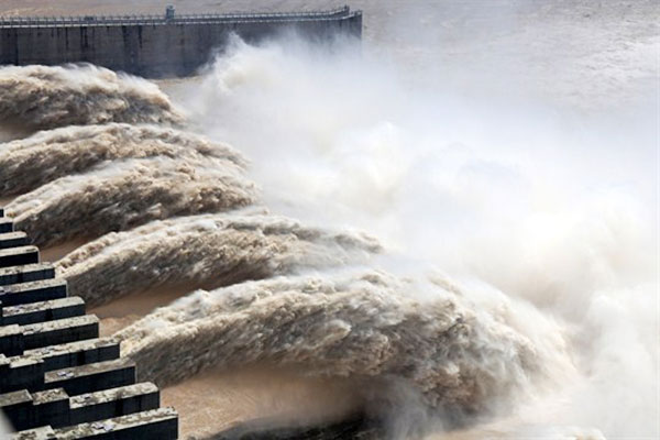
version opened to discharge the flood in Yichang, Hubei, China on 17 July 2018. Photo by TPG/CNS via AP Images
In fact, even among
bitter enemies, the historical record shows that water conflicts
around the world do get resolved, even to the point that
international cooperation often increases during droughts.
Similarly, as access to
irrigation water is threatened, one result can be mass migrations of
out-of-work, disgruntled people from the countryside to the cities -
invariably a recipe for political instability.
So it is little wonder
that water is being portrayed not only as a cause of armed conflict
in the past, but as the resource which will bring combatants to the
battlefield in this century.
Moreover, it fluctuates wildly in space and time, its management is usually fragmented, and it is often subject to vague or contradictory legal principles.
The 21st century has seen access to new technology which adds substantially to the ability both to negotiate and to manage transboundary waters more effectively.
More effective management of the root causes of water conflicts means that if there is to be water-related violence in the future, it is much more likely to be of the "water riots" variety than the "water wars" scenarios across national boundaries.
In any event, changing
circumstances, both in terms of the environment and available
technology, mean that water-management approaches must adapt as
well.
Illegal, unreported and unregulated (IUU) fishing threatens the economies of many developing nations, as dramatic reductions in fish stocks would mean economic calamity and the prospect of millions of jobs lost in vulnerable economies.
IUU fishing is also linked to criminal smuggling rackets, terrorist organizations, and human trafficking - including children trafficked into the fishing industry as laborers.
The good news is that governments, multilateral organizations, the private sector and NGOs have started to see IUU fishing for what it is:
While China's fisheries are overexploited and collapsing, its fish consumption is growing.
In order to meet the demand, China has built a large, state-subsidized, distant-water fishing fleet, which is getting more hostile, with illegal fishing by Chinese trawlers steadily increasing, especially in China's East Asia neighborhood.
China's behavior should
be considered an early warning sign of the security implications of
unmanaged fisheries and illegal fishing as two growing causes of
water conflicts around the world.
- Conflict and Cooperation Over
Shared Rivers - from WorldPoliticsReview Website
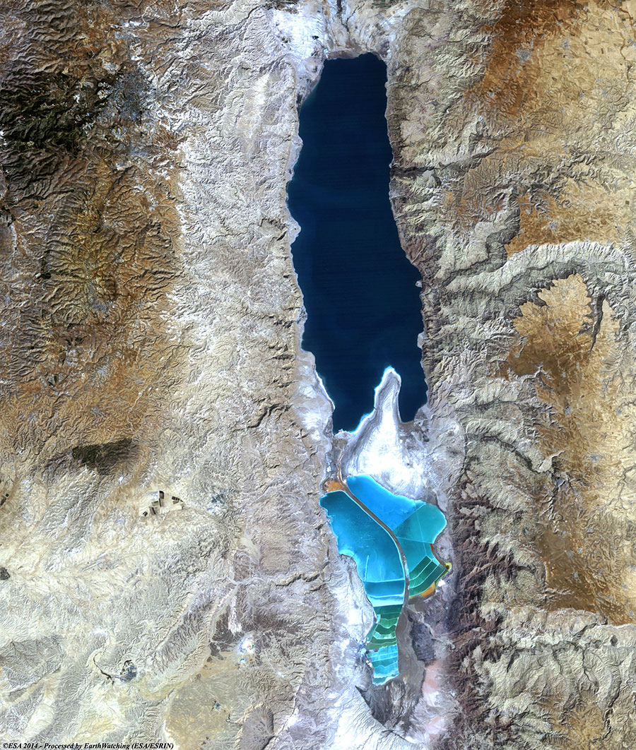
Photo: NASA satellite image of the Dead Sea.
Till taught by pain,
men know not
water's worth.
an eloquent
advocate for reason.
The collected salts left behind have resulted in an inhospitably briny lake eight times saltier than the sea, topped by a thin layer of the Jordan's relatively less-dense fresh water.
The differing salinity
levels between the river and the lake kept the Dead Sea in a
perpetually layered state, even while the lake's overall water level
remained fairly constant, since evaporation from the lake's surface
occurs at roughly the rate of the natural flow of the Jordan and
other tributaries and springs.
In this century, as more and more of the Jordan was diverted for the needs of these newly formed nations (Jordan, Syria and Lebanon, as well as Israel), the level of the lake began to drop, most recently by about one-half meter per year.
Greater amounts of the shoreline were exposed, and the lake was cut in half by the Lisan Straits.
The shallow southern half
all but dried up, and the potash works and health spas built to take
advantage of the lake's unique waters found themselves ever farther
from the shore.
In a hydrologic protest
against the loss of the Jordan River's flow, the Dead Sea
effectively rolled over in its grave.
But the event was a
symptom of a wider crisis of history-influencing proportions.
Jordan in particular ranks high on any list of countries facing water scarcity, as do the Palestinian areas of the West Bank and Gaza, whose access to adequate water is still closely controlled by Israel and has not yet been guaranteed by any peace treaty.
Over the last 50 years, most of the international conflicts over water have taken place between Israel and at least one of its neighbors, although the last was in 1970. In the Jordan River basin, for example, violence broke out in the mid-1960s over an "all-Arab" plan to divert the river's headwaters (itself a preemptive move to thwart Israel's intention to siphon water from the Sea of Galilee).
Israel and Syria
sporadically exchanged fire between March 1965 and July 1966, and
the water-related tensions in the basin have only recently begun to
dissipate.
The process of carving modern borders out of what was the Ottoman Empire dates to the end of World War I, and the struggles in the area around the Jordan headwaters remind us just how crucial to the debate the issue of water resources has been.
From the Sykes-Picot agreement to the Paris Peace Talks, through five Arab-Israeli wars and consequent armistice arrangements and later peace negotiations, the question of what will replace what was once a single entity and how its water will be divided remains less than fully resolved. Indeed, water was the last and most contentious issue resolved in negotiations over a 1994 peace treaty between Israel and Jordan.
Tellingly, it was
relegated to "final status" negotiations - along with the other most
difficult issues such as the status of Jerusalem and the right of
return of Palestinian refugees - between Israel and the
Palestinians.
The most prominent among them, as articulated in 1995 by Ismail Serageldin, a vice-president of the World Bank, holds that,
Invariably, such warnings
about "water wars," echoed regularly, point to the arid and hostile
Middle East as an example of a worst-case scenario, in part because
armies have in fact been mobilized and shots fired over this scarce
and precious resource.
So it is little wonder
that water is being portrayed not only as a cause of armed conflict
in the past, but as the resource which will bring combatants to the
battlefield in the 21st century.
While shots were fired over water between Israel and Syria between 1951-53 and 1964-66, the final military exchange - involving both tanks and aircraft on July 14, 1966 - stopped Syrian construction of the diversion project in dispute, effectively ending water-related tensions between the two states.
Water had nothing to do
with the strategic thinking of the 1967 Israeli-Arab war that broke
out almost a year later, or those that followed in 1967, 1973, and
1982. [1]
Of these, 21 lie in their entirety within international basins, and at least 33 countries have greater than 95 percent of their territory within these basins, meaning that they are essentially dependent for their water resources on sharing with their neighbors.
These include such
sizable countries as Hungary, Bangladesh, Belarus, and Zambia.
[2]
This reflects a sharp
increase from the 214 international basins listed in 1978, the last
time any official body attempted to delineate them. [4]
The increase reflects both political change (such as break up of the
Soviet Union and the Balkan states) and technological changes that
have made it possible to map water resources more accurately.
In order to examine the history of water conflicts more rigorously, researchers at Oregon State University undertook a three-year research project that attempted to compile a dataset of every reported water-related interaction between two or more nations, whether incidents of conflict or cooperation, over the past 50 years. [5]
The study documented more
than 1,800 such interactions that involved water as a scarce and/or
consumable resource or as a quantity to be managed - i.e., where
water was the driver of the events. [6]
The historical record shows that international water disputes do get resolved, even among bitter enemies, and even as conflicts erupt over other issues.
Some of the most vociferous enemies around the world have negotiated water agreements or are in the process of doing so. The institutions they have created frequently prove to be resilient over time and during periods of otherwise strained relations.
The Mekong Committee, for example, has functioned since 1957, exchanging data throughout the Vietnam War.
Secret "picnic table" talks have been held between Israel and Jordan since the unsuccessful Johnston negotiations of 1953-55, even though these neighbors were until only recently in a legal state of war. The Indus River Commission survived two wars between India and Pakistan.
And all 10 of the
countries that share the banks of the Nile are currently involved in
negotiations over cooperative development of the basin.
In those cases where
water has caused or exacerbated tensions, it is worth understanding
how it did so, in order to determine both how complications arise,
and how they are eventually resolved.
A general pattern has emerged for international basins over time. Countries that share access to a basin tend to first implement water-development projects unilaterally, on water within their territory, in order to avoid the political intricacies of jointly managing the shared resource.
At some point, one of the countries, generally the most powerful, will implement a project that impacts at least one of its neighbors.
This project can, in the absence of relations or institutions conducive to conflict resolution, become a flashpoint, heightening tensions and creating regional instability that require years or, more commonly, decades to resolve.
Treaties over the Indus
took 10 years of negotiations, the Ganges 30, and the Jordan 40.
This problem gets worse as the dispute gains in intensity, as illustrated by the ecosystems of the lower Nile, the lower Jordan, and the tributaries of the Aral Sea, all of which have fallen casualty to overuse upriver and to the intractability of international disputes.
During these periods,
threats and disputes rage across boundaries, like those between
Indians and Pakistanis and between Americans and Canadians.
Numerous violent incidents have occurred at the subnational level, generally between tribes, water-use sectors, or states/provinces. In fact, our recent research at Oregon State suggests that as the level at which the dispute occurs descends towards the locality, the likelihood and intensity of violence goes up. [8]
The many examples of
internal water conflicts range from interstate violence and death
along the Cauvery River in India, to California farmers blowing up a
pipeline meant for Los Angeles, to clashes between Chinese farmers
and police in Shandong in 2000, in response to government plans to
divert irrigation water to cities and industries.
For example, for the 30 years that the Gaza Strip was under Israeli occupation, water quality deteriorated steadily. Saltwater intrusion degraded local wells, and water-related diseases took a rising toll on the people living there. In 1987, the Palestinian uprising known as the Intifada broke out in the Gaza Strip, and quickly spread throughout the West Bank.
While it would be
simplistic to claim that water quality was a direct cause of the
conflict, it was undoubtedly an irritant exacerbating an already
tenuous situation.
In a pioneering work (The Water Footprint of Humanity), Sandra Postel identified those countries that rely heavily on irrigation, and whose agricultural water supplies are threatened either by a decline in quality or quantity.
The list includes many of the world's current security concerns, including,
A common assumption holds that scarcity of a critical resource drives people to conflict.
It feels intuitive:
Once again, though, our study at Oregon State found conclusions that were counterintuitive.
Arid climates harbored no more conflicts than humid climates, for instance, and international cooperation actually increased during droughts.
In fact, when we ran the numbers, none of the "obvious" variables proved decisive:
A more central variable, it turned out, was the strength of institutions for dealing with shared water resources.
If naturally arid countries tended to be more cooperative, it was due to the institutional strategies necessary for adapting to water-scarce environments.
Once we began to focus on
institutions - whether defined by formal treaties, informal working
groups, or generally warm relations - we began to get a clearer
picture of the settings most conducive to solving political tensions
over international waters, and those that are less favorable.
Even the existence of
technical working groups can provide some capability to manage
contentious issues, as they have in the Middle East.
In other words, the red
flag for water-related tension between countries is not water stress
per se, but rather the unilateral exercise of domination of an
international river, usually by a regional power.
So, too, are those over the Nile, a basin shared by 10 countries, with Egypt the last in line. In the late 1950s, hostilities broke out between Egypt and Sudan over Egypt's planned construction of the High Dam at Aswan.
The signing of a treaty between the two countries in 1959 defused tensions before the dam was built.
But even today, no water-sharing agreement exists between Egypt and Ethiopia (where some 85 percent of the Nile's flow originates), and a war of words has raged between the two nations for decades.
As is the case among those who share the Jordan, the Nile nations have begun in recent years to work cooperatively toward a solution, thanks in part to unofficial dialogues among scientists and technical specialists that have been held since the early 1990s.
More recently, a
ministerial-level "Nile Basin Initiative" has been facilitated by
the United Nations and the World Bank.
One way to answer that question is to identify those basins where dams or diversions that may negatively affect other countries are planned or under construction, and where no corresponding mechanism exists for resolving the disputes that are likely to result.
Our study identified 17 such basins, along with the four in which serious unresolved water disputes already exist or are being negotiated (Aral, Nile, Jordan, and Tigris-Euphrates).
These at-risk basins implicate 51 nations on five continents in just about every climatic zone. Eight of the basins are in Africa, primarily in the south, while six are in Asia, mostly in the southeast.
Few of them are on the
radar screens of water and security analysts.
China, moreover, has not been warm to notions of water sharing lately. It was one of just three countries that voted against a 1997 United Nations convention that established basic guidelines and principles for the use of international rivers.
Add in other destabilizing factors in the Salween basin - including the status of Tibet, indigenous resistance movements, opium production, and a burgeoning urban population in the region - and the trajectory for potential conflict begins to take shape.
Without a treaty in
place, or even regular dialogue between the nations about their
respective plans, there is little to buffer the inevitable shock as
construction begins.
Its watershed spans portions of Angola, Botswana, Namibia, and Zimbabwe, and its vast delta in northern Botswana is home to a world-renowned wildlife habitat - the "jewel of the Kalahari." In 1996, drought-prone Namibia revived colonial plans to divert Okavango waters to its capital city of Windhoek.
Angola and especially Botswana object to the scheme because of its potential harm to the populations and ecosystems that depend on the Okavango's flow for their existence.
The main institution that can help manage the dispute is the fledgling Okavango Commission, formed in 1994 to coordinate plans in the basin.
The commission has
recently received renewed support from the Southern Africa
Development Community, the U.S. Bureau of Reclamation, and other
agencies, but the water dispute continues to simmer.
The breakup of the Soviet Union resulted in several new international river basins almost overnight. Not surprisingly, institutional capacity for managing water disputes in them is weak.
The Kura-Araks river system, for example, runs through the politically volatile Caucasus, including the relatively young independent countries of,
The river system is the source of drinking water for large portions of these nations, but millions of tons of untreated sewage and industrial waste regularly push water pollution levels to between 10 and 100 times international standards.
On top of these problems,
some forecasts project severe water shortages within 10 years.
Back then it served as a
gateway on the Via Maris, the trade route between the ancient
world's two fertile crescents along the Nile and the Euphrates. The
river's constant source of water proved an irresistible draw to
travelers making the long journey, and Dan, built in a crescent
around the river's source springs, became one of the few major urban
centers in the area.
Over time, the Egyptians gave way to the Canaanites, who called the site Lais.
They, in turn, ceded the land to the Israelite tribe of Dan around 1100 B.C.E. The walls of Dan soon yielded to the Assyrians, whose might could not hold back the Persians, nor theirs the Greeks, nor theirs the Ptolemaics, nor theirs the Romans.
Given its history, then,
it is not surprising that, after 70 years of tension, today's
disputes over the Jordan's water have yet to be resolved.
Today, it travels through a patchwork of sovereignties:
These days, no amount of passports or diplomatic connections would allow for traveling the entire length of the road.
But in the wrangling that
followed the end of World War I, it was this very road - in
particular, French insistence on access to it - that resulted in the
Jordan River watershed being drawn and quartered in a similar
piecemeal fashion.
|