|

by Mark Dunphy
October 10, 2011
from
IrishWeatherOnLine Website

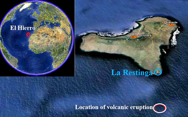
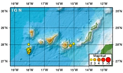
El Hierro, The Canary
Islands, from space
in this MODIS
satellite image on Oct. 7 2011
A submarine volcanic eruption is taking
place approximately 5 kilometers off the southern coast of El Hierro,
the smallest of The Canary Islands.
The Mayor of La Frontera (El Hierro), David Cabrera, confirmed in an
interview on Radio iron Garoé that ‘underwater eruption’ is taking
place about 900 meters beneath the sea surface five kilometers south
of La Restinga. The eruption has been ongoing for four hours, the
Mayor said.
Spanish newspaper laopionion.es quoted the Minister of emergencies
of the Cabildo of El Hierro, Maria del Carmen Morales, as saying the
eruption is taking place because,
‘the seismic movement of 4.3
occurred on Saturday afternoon caused a fissure, from where the
energy is been released’.
Scientists remain unclear if the emissions
are gas or lava.
A meeting of PEVOLCA - Actualidad Volcánica de Canarias,
comprising representatives of Instituto Geografico Nacional (IGN)
and The Canary Islands Government, took place on the Spanish Island.
In a statement issued shortly before 4
p.m. local time, the IGN stated (translated from spanish language
press release):
“…although there is no certainty
that at the moment is producing an underwater volcanic eruption,
since the last morning there has been a release of fluids and
volcanic gas on the southern coast of the island.”
“Scientists from IGN have reported to the direction of the Plan
all the indicators that have been analyzed to point towards the
possibility of the beginning of an eruptive process that has
changed the type of waves that have registered seismographs in
the last hours, implying the beginning of emission of gases or
lava…”
“The helicopter of the emergency and rescue of the Government of
the Canary Islands (GES) group has done reconnaissance flights
during the morning without exit of volcanic material to the
surface.”
“Although this activity is not exposed to, the direction of the
PEVOLCA encourages people to perform their usual tasks normally
and to remain attentive to any unusual activity”, the statement
added.
Meanwhile, La Agencia Estatal (CSIC)
scientists equipped with special detection cameras have been making
numerous sorties over coastal areas of El Hierro in an attempt to
verify the existence and scale of the underwater eruption.
This is Spain’s first volcanic eruption
since the eruption in 1971 of the Teneguía volcano on the island of
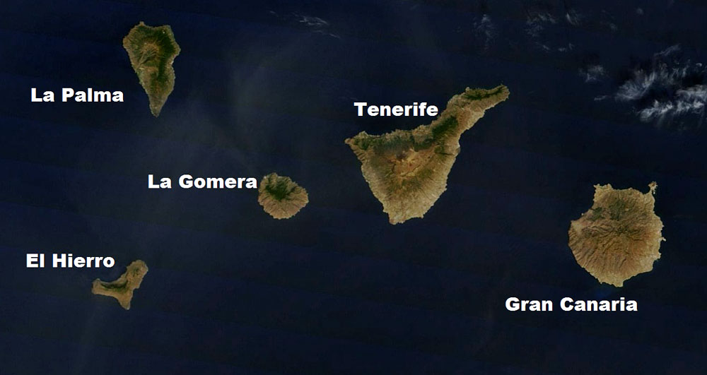
La Palma (Canary Islands), located to the north of El Hierro.
Initial reports of the eruption were received from crews on board
four separate ships.
-
On Monday afternoon, Terra Noticias/Agencia EFE
reported that an eruption occurred 2000 meters below sea level in
the Las Calmas sea at 10.43 local time (05:43 EDT).
-
Spanish newspaper El Mundo placed the
depth of the eruption at 1300 meters.
-
Local media agency Canarias7 reported on Monday that Government
authorities have suspended ferry activities to and from the 285
square-kilometer island.
-
English language newspaper islandconnections.eu reported:
Background To
The Eruption


El Hierro
(highlighted) on Google Earth
The eruption takes place amidst an
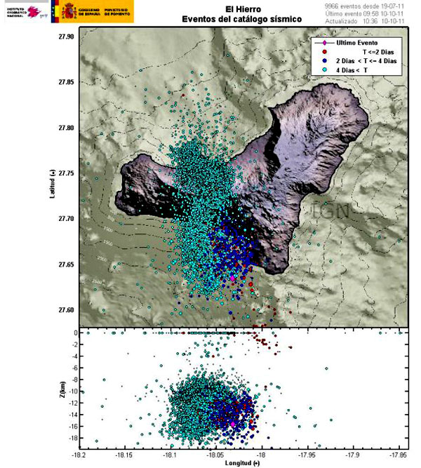
unprecedented earthquake swarm in El Hierro.
The number of
earthquakes recorded since July 17, 2011 on El Hierro has now
exceeded 10,000.
Hierro, a shield volcano, has had a single historic eruption from
the Volcan de Lomo Negro vent in 1793. The eruption lasted
approximately one month and produced lava flows.
The recent surge in the number and intensity of earthquakes prompted
officials from the IGN and The Canary Islands Government to raise
the alert level for the Hierro volcano to ‘Yellow’ late last month.
The alert remained in place on Monday, but the estimated 11,000
residents of El Hierro were being reassured not to be alarmed.
The majority of the earthquake activity shifted from El Golfo in the
island’s northwest to beneath the Las Calmas Sea in the south
earlier this month. Surface deformations exceeding 35mm have also
been recorded on the island in recent weeks.
Evacuations
A dramatic rise in recorded earthquakes on El Hierro prompted
officials to evacuate some local residents, shut El Hierro’s main
tunnel, and close local schools on 27 September.
The Spanish Civil Guard (Guardia Civil) advised almost 50 residents
of the municipality of La Frontera to leave their homes because of
landslide fears. Two units of the Spanish military’s emergency
intervention unit (EMU) were also placed on standby to depart the
nearby island of Tenerife to assist in the possible evacuation of
hundreds of other El Hierro residents.
Meanwhile, the island’s main tunnel (Tunel del Golfo), which links
Frontera to Valverde, was shut forcing motorists to travel across
the 280-sq-km island via a mountain road.
The Cabildo de El Hierro also ordered
the closure of schools.
Latest seismic activity on El Hierro
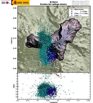
IGN graphic of recent earthquakes
(marked in red) on El Hierro
Possible Harmonic Tremor On El Hierro
Rushed
plot. El Hierro may be experiencing harmonic
tremor at this moment. Layers are on a 128 x 128
interpolated grid of 2° Moho data and 1' terrain
and bathemetry data.
Earthquake Swarms
Earthquake swarms are events
where a local area experiences sequences of many earthquakes
striking in a relatively short period of time.
The length of time used to define the
swarm itself varies, but the United States Geological Survey (USGS)
points out that an event may last for days, weeks, or months.
Harmonic Tremors
Harmonic tremor describes a long-duration release of seismic energy,
with distinct spectral (harmonic) lines, that often precedes or
accompanies a volcanic eruption.
More generally, a volcanic tremor is a
sustained signal that may or may not possess these harmonic spectral
features.
El Hierro’s
Volcanic/Seismic Past
El Hierro is situated in the most southwestern extreme of the
Canaries.
The island was formed after three successive eruptions,
and consequent accumulations, the island emerged from the ocean as
an imposing triangular pyramid crowned by a volcano more than 2,000
meters high.
The volcanic activity, principally at the convergence of the three
ridges, resulted in the continual expansion of the island. A mere
50,000 years ago, as a result of seismic tremors which produced
massive landslides, a giant piece of the island cracked off, crashed
down into the ocean and scattered along the seabed.
This landslide
of more than 300 km3 gave rise to the impressive amphitheatre of the
El Golfo valley and at the same time caused a tsunami that most
likely rose over 100 meters high and probably reached as far as the
American coast.

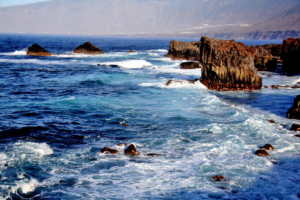
El Golfo, El Hierro, The Canary Islands (Spain)
where the majority
of earthquakes have been recorded up to recently
According to the
Global Volcanism Program, the massive Hierro shield
volcano is truncated by a large NW-facing escarpment, seen here from
the east, which formed as a result of gravitational collapse of the
volcano.
The steep-sided 1500-m-high scarp towers above a low lava
platform bordering 12-km-wide El Golfo Bay, which is barely visible
at the extreme left.
Holocene cones and flows are found both on the
outer flanks and in the El Golfo depression. The last eruption,
during the 18th century, produced a lava flow from a cinder cone on
the NW side of El Golfo.
According to
ElHierro.com:
“Although over 200 years have elapsed
since the last eruption, El Hierro has the largest number of
volcanoes in the Canaries with over 500 open sky cones, another 300
covered by the most recent outflows, and some 70 caves and volcanic
galleries, notably the Don Justo cave whose collection of channels
surpasses 6 km in length.”
El Hierro is located south of Isla de la Palma (population 86,000),
currently the most volcanically active of the Canary Islands. About
a half a million years ago, the volcano, Taburiente, collapsed with
a giant landslide, forming the
Caldera de Taburiente.
Since the
Spanish occupation, there have been seven eruptions.
|